
The Rhine is one of the major European rivers. The river begins in the Swiss canton of Graubünden in the southeastern Swiss Alps. It forms part of the Swiss-Liechtenstein, Swiss-Austrian, and Swiss-German borders. After that the Rhine defines much of the Franco-German border, after which it flows in a mostly northerly direction through the German Rhineland. Finally in Germany, the Rhine turns into a predominantly westerly direction and flows into the Netherlands where it eventually empties into the North Sea. It drains an area of 9,973 sq km and its name derives from the Celtic Rēnos. There are also two German states named after the river, North Rhine-Westphalia and Rhineland-Palatinate.

Batavia is a historical and geographical region in the Netherlands, forming large fertile islands in the river delta formed by the waters of the Rhine and Meuse rivers. During the Roman empire, it was an important frontier region and source of imperial soldiers. Its name is possibly pre-Roman.

The IJssel is a Dutch distributary of the river Rhine that flows northward and ultimately discharges into the IJsselmeer, a North Sea natural harbour. It more immediately flows into the east-south channel around the Flevopolder, Flevoland which is kept at 3 metres below sea level. This body of water is then pumped up into the IJsselmeer.

Rijnwaarden was a municipality in the province of Gelderland, in the eastern Netherlands. The Rhine enters the Netherlands at its location. Rijnwaarden was merged into the municipality of Zevenaar on 1 January 2018.

Alphen aan den Rijn is a city and municipality in the western Netherlands, in the province of South Holland. The city is situated on the banks of the river Oude Rijn, where the river Gouwe branches off. The municipality had a population of 112,587 in 2021, and covers an area of 132.50 km2 (51.16 sq mi) of which 6.27 km2 (2.42 sq mi) is water.

Nederrijn is the Dutch part of the Rhine from the confluence at the town of Angeren of the cut-off Rhine bend of Oude Rijn (Gelderland) and the Pannerdens Kanaal. The city of Arnhem lies on the right (north) bank of the Nederrijn, just past the point where the IJssel branches off. The Nederrijn flows on to the city of Wijk bij Duurstede, from where it continues as the Lek. The once-important but now small Kromme Rijn branch carries the name "Rhine" towards the city of Utrecht.
The Pannerdens Kanaal is a canal in the Netherlands that was dredged between 1701 and 1709 to cut off a large, shallow bend of the river Rhine and so improve river traffic and water regulation.

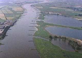
The Bijlands Kanaal is a canal in the Dutch province of Gelderland, near the Dutch-German border. It is currently by far the most important river-stretch of the Rhine when that major river enters the Netherlands.

The Oude Rijn is a branch of the Rhine delta in the Dutch provinces of Utrecht and South Holland, starting west of Utrecht, at Harmelen, and running by a mechanical pumping station into the North Sea at Katwijk. Its present-day length is 52 kilometres.

Lobith is a village in the Dutch province of Gelderland. It is located in the municipality of Zevenaar. Traditionally, it is said that the Rhine enters the Netherlands at Lobith, although in reality, this happens about 4 km further upstream, near Spijk.

Pannerden is a village in the Dutch province of Gelderland. It is located in the municipality of Zevenaar.

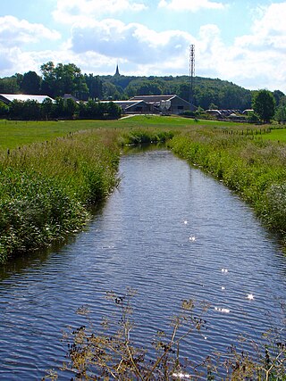
The Oude IJssel or Issel is a river in Germany and the Netherlands approximately 82 km (51 mi) long. It is a right tributary of the river IJssel. Oude IJssel is Dutch for "Old IJssel"; the Oude IJssel was the upper course of the IJssel until the connection with the Rhine was dug, possibly in the Roman era.
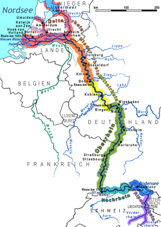
The Lower Rhine flows from Bonn, Germany, to the North Sea at Hook of Holland, Netherlands ; alternatively, Lower Rhine may refer to the part upstream of Pannerdens Kop, excluding the Nederrijn.

The Rhine–Meuse–Scheldt delta is a river delta in the Netherlands formed by the confluence of the Rhine, the Meuse and the Scheldt rivers. In some cases, the Scheldt delta is considered a separate delta to the Rhine–Meuse delta. The result is a multitude of islands, branches and branch names, in which a waterway that appears to be one continuous stream may have numerous separate names for different sections, e.g. Rhine → Bijlands Kanaal → Pannerdens Kanaal → Nederrijn → Lek → Nieuwe Maas → Het Scheur → Nieuwe Waterweg. Since the Rhine contributes most of the water, the term "Rhine Delta" is commonly used, although this name is also used for the delta where the Alpine Rhine flows into Lake Constance. By some calculations, the Rhine–Meuse–Scheldt delta covers 25,347 km2 (9,787 sq mi), making it the largest in Europe.

The Oude Maas is a distributary of the river Rhine, and a former distributary of the river Maas, in the Dutch province of South Holland. It begins at the city of Dordrecht where the Beneden Merwede river splits into the Noord and the Oude Maas. It ends when it joins the Nieuwe Maas to form Het Scheur.
Die Wild is a small stream on the border between Germany and The Netherlands. It flows south of the Dutch town of 's-Heerenberg and the German village of Elten towards the north of the Dutch village of Spijk. North of Lobith it flows into the Oude Rijn, an old branch of the Rhine.

Schenkenschanz is a small community in North Rhine-Westphalia, Germany that was incorporated into the town of Kleve (Cleves) in 1969. Schenkenschanz is site of the former Schenkenschans fortress that was of significance in the Dutch Revolt.

Oud-Zevenaar is a village in the municipality of Zevenaar in the province of Gelderland, the Netherlands. It is located to the south of Zevenaar
