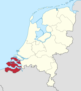
Zeeland is the westernmost and least populous province of the Netherlands. The province, located in the south-west of the country, borders North Brabant to the east, South Holland to the north, and the country of Belgium to the south and west. It consists of a number of islands and peninsulas and a strip bordering the Flemish provinces of East and West Flanders. Its capital is Middelburg with a population of 48,544 as of November 2019, the largest municipality in Zeeland is Terneuzen. Zeeland has two seaports: Vlissingen and Terneuzen. Its area is 2,934 square kilometres (1,130 sq mi), of which 1,151 square kilometres (440 sq mi) is water, and it has a population of 383,689 as of November 2019.
The Delta Works is a series of construction projects in the southwest of the Netherlands to protect a large area of land around the Rhine–Meuse–Scheldt delta from the sea. Constructed between 1954 and 1997, the works consist of dams, sluices, locks, dykes, levees, and storm surge barriers located in the provinces of South Holland and Zeeland.

The Eastern Scheldt is a former estuary in the province of Zeeland, Netherlands, between Schouwen-Duiveland and Tholen on the north and Noord-Beveland and Zuid-Beveland on the south. It also features the largest national park in the Netherlands, founded in 2002.

Noord-Beveland is a municipality and region in the southwestern Netherlands and a former island, now part of the Walcheren-Zuid-Beveland-Noord-Beveland peninsula. Noord-Beveland is enclosed by the Oosterschelde estuary to the north, and the former straits, now combined lake, of Veerse Meer and Zandkreek to the south. As part of the Delta Works, dams have connected Noord-Beveland to Walcheren and Zuid-Beveland.

Veere is a municipality with a population of 22,000 and a town with a population of 1,500 in the southwestern Netherlands, in the region of Walcheren in the province of Zeeland.

Zuid-Beveland is part of the province of Zeeland in the Netherlands north of the Western Scheldt and south of the Eastern Scheldt.

The Canal through Walcheren in the Netherlands crosses the east of Walcheren. It connects the Westerschelde and the Veerse Meer.

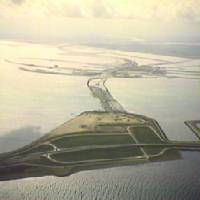
The Oosterscheldekering, between the islands Schouwen-Duiveland and Noord-Beveland, is the largest of the Delta Works, a series of dams and storm surge barriers, designed to protect the Netherlands from flooding from the North Sea. The construction of the Delta Works was a response to the widespread damage and loss of life in the North Sea flood of 1953.
The Veerse Gat or Veeregat was the sea channel between Walcheren and Noord-Beveland islands in Zeeland in the Netherlands. In 1961 as part of the Delta Plan it was blocked off by the Veerse Gatdam and made into an inland lake called Veerse Meer.

Colijnsplaat is a village in the Province of Zeeland, the Netherlands It is a part of the Municipality of Noord-Beveland, and lies about 20 km (12 mi) northeast of Middelburg.

Kamperland is a village in the Dutch province of Zeeland. It is a part of the municipality of Noord-Beveland, and lies about 11 km northeast of Middelburg.

Geersdijk is a village in the Dutch province of Zeeland. It is a part of the municipality of Noord-Beveland, and lies about 13 km northeast of Middelburg.

The Veerse Meer is a lagoon in the southwest Netherlands in the province of Zeeland.
The Battle of Zeeland occurred on the Western Front during the early stages of the German assault on France and the Low Countries during World War II. Several Dutch and French units attempted to hold off the German onslaught by making a determined defense of the Dutch province of Zeeland. The battle lasted eight days and was a defeat for the French and Dutch forces defending the province.
The Sloedam was a dam, connecting the Dutch islands Zuid-Beveland and Walcheren near the town of Arnemuiden. Before the dam was constructed, these islands were separated by a stretch of water called the Sloe. The Sloedam was constructed in 1871 for the railway connection between the towns of Flushing and Roosendaal, the so-called Zeeuwse Lijn. After World War II, the areas to the south of the dam were poldered. Since the Veerse Gat estuary was closed off by the Veerse Gatdam in 1961, the Sloedam no longer functions as a primary defense against the sea.
The Philipsdam is a dam constructed as part of the Delta Works in the Netherlands. It separates water of the lakes Krammer and Volkerak from the Oosterschelde. The dam connects the Grevelingendam to Sint Philipsland.

The Inundation of Walcheren was the intentional, but uncontrolled military inundation, effected by bombing the sea dikes of the former island of Walcheren in Zeeland by the Allies on and after 3 October 1944 in the context of Operation Infatuate during the Battle of the Scheldt after the Allied Invasion of Normandy during World War II. Though the inundation was justified by military necessity, it is controversial whether it was proportional in view of the predictable devastating effects for the civilian population, and the ecology of the island. The fact that the breaches in the sea dikes of the island remained open for a very long time, subjecting the island to the full impact of the twice-daily tides, caused severe damage to agricultural land and infrastructure, and severe hardship for the civilian population. Leaving the breaches open for such a long time, which was unavoidable due to the war-time lack of resources making closing impossible, subjected them to scouring by the tides, that widened and deepened them to such an extent that closing them eventually became extremely difficult, necessitating the development of new dike-building techniques, such as the use of caissons. The last breach was closed on 23 October 1945 and the draining of the island took until early 1946. Only after that could rebuilding the infrastructure and reconstructing the housing stock and the island's economy start. Walcheren was spared during the North Sea Flood of 1953 that devastated many other parts of Zeeland.
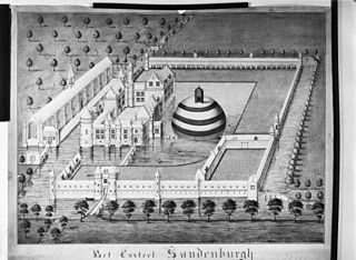
Zandenburg was a famous castle just south of Veere. Nothing remains of it, except some foundations below ground level.

The Volkerakdam or Volkerakwerken is the name given to a group of hydraulic engineering structures located between Goeree-Overflakkee and North Brabant in The Netherlands. The works are not a single dam, but are composed of three distinct structures: a dam between Goeree-Overflakkee and Hellegatsplein, a series of locks from Hellegatsplein to North Brabant, and a bridge from Hellegatsplein to Hoekse Waard. The works cross three separate bodies of water: the Haringvliet, Hollands Diep and Volkerak. The works together comprise the fifth project of the Delta Works.
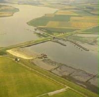
The Zandkreekdam is a dam in The Netherlands which connects Zuid-Beveland with Noord-Beveland, and separates the Oosterschelde from the Veerse Meer. A navigation lock in the dam permits shipping connections to Middelburg and Vlissingen, via the Veerse Meer and the Walcheren navigation channel. The Zandkreekdam is 830 metres in length, and was the second project to be constructed as part of the Delta Works, having been proposed by Johan van Veen as part of the Drie-Eilanden Plan which originated in 1930s.


