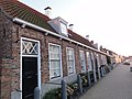
Veere is a municipality with a population of 22,000 and a town with a population of 1,500 in the southwestern Netherlands, in the region of Walcheren in the province of Zeeland.

Westdorpe is a village in the Dutch province of Zeeland. It is a part of the municipality of Terneuzen, and lies about 31 km southeast of Vlissingen.

Zoutelande is a village in the southwestern Netherlands. It is located in the municipality of Veere, Zeeland, between Dishoek and Westkapelle on the former island Walcheren. On 1 January 2005 it had 1,556 inhabitants. Originally, Zoutelande was mainly an agricultural village. The village's character changed slowly into a tourist resort as the demand for beach recreation rose from about the middle of the 19th century.

Noordgouwe is a village in the Dutch province of Zeeland. It is a part of the municipality of Schouwen-Duiveland, and lies about 5 km north of Zierikzee.
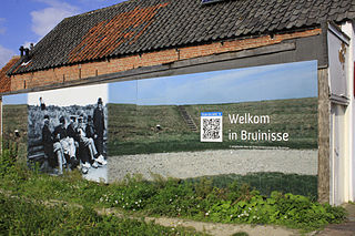
Bruinisse is a village in the south-west of the Netherlands. It is located in the municipality of Schouwen-Duiveland, Zeeland.

Gapinge is a village in the Dutch province of Zeeland. It is a part of the municipality of Veere, and lies about 6 km north of Middelburg.
Breezand is a seaside resort and bungalow park of Vrouwenpolder in the Dutch province of Zeeland. It is a part of the municipality of Veere, and lies about 10 km north of Middelburg.

Serooskerke is a village in the Dutch province of Zeeland. It is a part of the municipality of Veere, and lies about 6 km north of Middelburg.

Oostkapelle is a village in the Dutch province of Zeeland. It is a part of the municipality of Veere, and lies about 9 km north of Middelburg. Oostkapelle was a separate municipality until 1966, when it was merged with Domburg.

Meliskerke is a village in the Dutch province of Zeeland. It is a part of the municipality of Veere, and lies about 8 km west of Middelburg.
Koudekerke is a village in the region of Walcheren in the Dutch province of Zeeland. It is a part of the municipality of Veere. As of 2018, the census reported the village has a population of 3,419, making it the largest settlement in Veere. The built-up area of the village was 0.55 km², and contained 1,133 residences.
Biggekerke is a village in the Dutch province of Zeeland. It is a part of the municipality of Veere, and lies about 6 km northwest of Vlissingen.

Kortgene is a small city in the southwest Netherlands. It is located in the municipality of Noord-Beveland, Zeeland, about 15 km northeast of Middelburg. It received city rights in 1431, but was flooded in 1530 and 1532. The new settlement received city rights in 1684.

Colijnsplaat is a village in the Province of Zeeland, the Netherlands It is a part of the Municipality of Noord-Beveland, and lies about 20 km (12 mi) northeast of Middelburg.

Wissenkerke is a village in the Dutch province of Zeeland. It is a part of the municipality of Noord-Beveland, and lies about 20 km northeast of Middelburg.

Stavenisse is a village in the Dutch province of Zeeland. It is a part of the municipality of Tholen, and lies about 22 kilometres (14 mi) west of Bergen op Zoom.

Hoofdplaat is a village in the Dutch province of Zeeland. It is located on the Westerschelde, about 7 km east of Breskens, in the municipality of Sluis.
Nieuw- en Sint Joosland of Nieuwland is a village and a former municipality in the southeast of Walcheren, at the edge of the island, in the municipality Middelburg, in the Dutch province of Zeeland. It has about 1300 inhabitants. Because of its relatively late foundation, Nieuw- en Sint Joosland is not a churchvillage, but more of a wegdorp, despite its clear village centre.

Ritthem is a village in the Dutch province of Zeeland. It is located in the municipality of Vlissingen, about 4 kilometres east of the city.

Zanddijk is a neighbourhood of Veere and former village in the municipality of Veere, Zeeland, Netherlands.