Zanddijk

Last updated
Zanddijk
Neighbourhood and former village
Veere-Zanddijk ruin church tower 1812.jpg
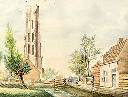
Ruined church tower of Zanddijk (1812)
2010-NL-P09-Zeeland-positiekaart-gemnamen.jpg
Red pog.svg
Zanddijk
Location in the province of Zeeland in the Netherlands
Netherlands location map.svg
Red pog.svg
Zanddijk
Zanddijk (Netherlands)
Coordinates: Coordinates: 51°32′22″N3°39′30″E / 51.53944°N 3.65833°E / 51.53944; 3.65833
Country Netherlands
Province Zeeland
Municipality Veere
Area
[1]
  Total0.40 km2 (0.15 sq mi)
Elevation
[2]
3.1 m (10.2 ft)
Population
 (2021) [1]
  Total855
  Density2,100/km2 (5,500/sq mi)
Time zone UTC+1 (CET)
  Summer (DST) UTC+2 (CEST)
Postal code
4351 [1]
Dialing code 0118

Zanddijk is a neighbourhood of Veere and former village in the municipality of Veere, Zeeland, Netherlands. [3]

History

The hamlet was probably founded in the first half of the twelfth century when some local farmers went to live on a dike made of sand, for which the hamlet was named. [4] (Zanddijk literally means "sand dike".) By 1153 Zanddijk had become a lordship. [4] In 1247 Hendrik Wisse van Borsele inherited the lordship and had a fort constructed there. [4] Under the Van Borsele  [ nl ]s, Zanddijk grew into a wealthy village. [4] Veere was founded on the lordship's territory and quickly grew into a city, overshadowing Zanddijk itself. [4] In 1347 it split off from the lordship. [4] In 1439 parts of Zanddijk were acquired by Veere and in 1574 the rest were put under its control. [4] During the Beeldenstorm its church was damaged but not destroyed; but soon after, it was destroyed anyway. [4] In 1572 Veere went over to the Dutch and provided troops for the Siege of Vlissingen. [4] During the Eighty Years' War, in 1748 it counted only 416 inhabitants. [4] During the Coalition Wars the French built fortifications around the village. [4] In the 1930s its strategic position again saw Zanddijk the location of a line of fortification. [5] [6]

Related Research Articles

Veere Municipality and town in Zeeland, Netherlands

Veere is a municipality with a population of 22,000 and a town with a population of 1,500 in the southwestern Netherlands, in the region of Walcheren in the province of Zeeland.

Yerseke Village in Zeeland, Netherlands

Yerseke is a village situated on the southern shore of the Oosterschelde estuary in the Dutch province of Zeeland. A separate municipality until 1970, it today forms part of the municipality of Reimerswaal. As of 2010 Yerseke had a recorded population of 6,695 inhabitants, living in 2,680 households.

Bruinisse Village in Zeeland, Netherlands

Bruinisse is a village in the south-west of the Netherlands. It is located in the municipality of Schouwen-Duiveland, Zeeland.

Ellemeet Village in Zeeland, Netherlands

Ellemeet is a village in the Dutch province of Zeeland. It is a part of the municipality of Schouwen-Duiveland, and lies about 26 km west of Hellevoetsluis.

Vrouwenpolder Village in Zeeland, Netherlands

Vrouwenpolder is a village in the Dutch province of Zeeland. It is a part of the municipality of Veere, and lies about 9 km north of Middelburg. The name is derived from "the polder of Our Lady", referring to the Virgin Mary.

Koudekerke Village in Zeeland, Netherlands

Koudekerke is a village in the region of Walcheren in the Dutch province of Zeeland. It is a part of the municipality of Veere. As of 2018, the census reported the village has a population of 3,419, making it the largest settlement in Veere. The built-up area of the village was 0.55 km², and contained 1,133 residences.

Biggekerke Village in Zeeland, Netherlands

Biggekerke is a village in the Dutch province of Zeeland. It is a part of the municipality of Veere, and lies about 6 km northwest of Vlissingen.

Colijnsplaat Town in Zeeland, Netherlands

Colijnsplaat is a village in the Province of Zeeland, the Netherlands It is a part of the Municipality of Noord-Beveland, and lies about 20 km (12 mi) northeast of Middelburg.

Nieuwdorp Village in Zeeland, Netherlands

Nieuwdorp is a village in the Dutch province of Zeeland. It is a part of the municipality of Borsele, and lies about 9 km east of Middelburg.

Lewedorp Village in Zeeland, Netherlands

Lewedorp is a village in the Dutch province of Zeeland. It is a part of the municipality of Borsele, and lies about 9 km east of Middelburg.

Heinkenszand Town in Zeeland, Netherlands

Heinkenszand is a town in the Dutch province of Zeeland. It is a part of the municipality of Borsele, and lies about 14 km east of Middelburg.

s-Gravenpolder Village in Zeeland, Netherlands

's-Gravenpolder is a village in the Dutch province of Zeeland. It is a part of the municipality of Borsele, and lies about 21 kilometres east of Middelburg.

s-Heer Abtskerke Village in Zeeland, Netherlands

's-Heer Abtskerke is a village in the Dutch province of Zeeland. It is a part of the municipality of Borsele, and lies about 19 km east of Middelburg.

Ovezande Village in Zeeland, Netherlands

Ovezande is a village in the Dutch province of Zeeland. It is a part of the municipality of Borsele, and lies about 16 km east of Middelburg.

Kwadendamme Village in Zeeland, Netherlands

Kwadendamme is a village in the Dutch province of Zeeland. It is a part of the municipality of Borsele, and lies about 20 km east of Middelburg.

Baarland Village in Zeeland, Netherlands

Baarland is a village in the Dutch province of Zeeland. It is a part of the municipality of Borsele, and lies about 21 km east of Middelburg.

Ellewoutsdijk Village in Zeeland, Netherlands

Ellewoutsdijk is a village in the Dutch province of Zeeland. It is a part of the municipality of Borsele, and lies about 18 km east of Vlissingen.

Wemeldinge Village in Zeeland, Netherlands

Wemeldinge is the oldest village in the Zuid-Beveland area of the Dutch province of Zeeland. It is located in the municipality of Kapelle, about 4 km northwest of Yerseke. It is located within the Eastern Scheldt national park.

Zandenburg

Zandenburg was a famous castle just south of Veere. Nothing remains of it, except some foundations below ground level.

Wolfert III van Borselen

Wolfert III van Borselen was Lord of Veere and Zandenburg.

References

  1. 1 2 3 "Kerncijfers wijken en buurten 2021". Central Bureau of Statistics. Retrieved 22 April 2022.
  2. "Postcodetool for 4351AA". Actueel Hoogtebestand Nederland (in Dutch). Het Waterschapshuis. Retrieved 22 April 2022.
  3. "Veere". Plaatsengids (in Dutch). Retrieved 22 April 2022.
  4. 1 2 3 4 5 6 7 8 9 10 11 "Thema: Het oude Zanddijk". www.stichtingveere.nl. Retrieved 2020-04-13.
  5. Nationaal Comité 4 em 5 mei & Noordhoff Atlasproducties. De Bosatlas van de Tweede Wereldoorlog. 75 Jaar Vrijheid, Vfonds, Rijksoverheid, Nationale Postcode Loterij. p. 36.
  6. "Zanddijk, Zuid-Beveland, Zeeland | Bunkersite.com". bunkersite.com. Retrieved 2020-04-13.