Philipsdam

Last updated

Philipsdam
Philipsdam-03.jpg

The Philipsdam
Coordinates 51°39′41″N4°9′42″E / 51.66139°N 4.16167°E / 51.66139; 4.16167
CarriesN257
Owner Rijkswaterstaat
Characteristics
Total length6.1 kilometres (3.8 mi)
History
ArchitectF.W. de Vlaming (locks and buildings)
F.L. Halenbeek (Landscape)
Engineering design byDeltadienst
Constructed bySeveral contractors, including:
Combinatie Zinkcon bv
Aannemers Combinatie Zinkwerken bv
J. Heijmans bv
Baggermaatschappij 'Holland' bv.
Construction start1976
Construction end1987
Location
Philipsdam
The lock under construction on Philipsdam Philipsdam-01.jpg
The lock under construction on Philipsdam
the lake Krammer and Philipsdam Philipsdam-02.jpg
the lake Krammer and Philipsdam

The Philipsdam is a compartmentalisation dam constructed as part of the Delta Works in the Netherlands. It separates water of the lakes Krammer and Volkerak from the Oosterschelde, and connects the Grevelingendam to Sint Philipsland. [1]

Contents

History, design, and construction

Design and optioneering

The need for the dam

In 1974, it was decided by Rijkswaterstaat and the Den Uyl cabinet to construct the Oosterscheldekering as a storm surge barrier at the mouth of the Oosterschelde, instead of completely closing off the tidal inlet at that location. The construction of the Oosterscheldekering required the compartmentalisation of the basin. [2]

The compartmentalisation model chosen involved the construction of the Philipsdam, the Oesterdam, and a discharge channel for managing the level and quality of the lake that would then form behind the dams. The overall project was also required to create a freshwater lake for water management purposes, ensure a tide-free navigation on the Scheldt-Rhine connection, and achieve a tidal difference of 2.7m at Yerseke. [2]

Optioneering and preliminary design

To prevent unacceptable flow velocities from being realised in the Scheldt-Rhine Canal during the works, the closing phases of both the Philipsdam and the Oesterdam had to be coordinated with each other. [3] A number of alternatives to the final location of the Philipsdam and the lock complex were investigated, with an important consideration being the preservation of valuable intertidal areas along with considerations of the closure method to be employed. [4] [5] [6]

The decision-making process for the nature and location of the Philipsdam involved a comprehensive consideration of multiple factors, leading to the selection of the variant at a sandbank known as Plaat van de Vliet as the preferred option. Key considerations included: [7] The connection of the damn to the Grevelingendam instead of the southern shore of Goeree-Overflakkee was chosen to allow for the option of turning the Grevelingenmeer into a freshwater basin by feeding it via a discharge sluice from the Krammer, which was ultimately decided against. [8] The benefit of this route is that it also removed the requirement for an additional road bridge across the Krammer instead connecting it to the existing road over the Grevelingendam. [8]

  • Hydrology and soil mechanics: The Plaat van de Vliet option was favoured for its hydrological aspects, which were thought to cause minimal disruption to flow speeds in the Krammer during construction. The flow speeds in the Krammer were expected to increase by 20% as long as the Slaak was still open, due to the construction of the work island with salt control basins on the Plaat van de Vliet. The increase in flow speeds along the sandbank known as the Plaat van Oude Tonge was anticipated to be less than 10%. No significant impact was expected on the Zijpe. [9] Soil mechanics considerations favoured an eastern connection to St.-Philipsland to ensure the stability of the dam and minimise ground settlement risks.
Table: Maximum speeds and volumes
WaterwayMax. Ebb Speed (m/s)Max. Ebb Volume (m³/s)Max. Flood Speed (m/s)Max. Flood Volume (m³/s)
Slaak0.920000.752000
Krammer1.05110001.0512500
  • Environmental impact: The decisions on where and how to construct the dam emphasised preserving valuable mudflats and minimising environmental disruption. The Plaat van de Vliet variant, with an eastern connection to St.-Philipsland, was preferred for its ability to preserve a significant portion of valuable mudflats along St.-Philipsland’s shore, balancing the need for tidal influence and freshwater impact. [9]
  • Water management: The compartmentalisation aimed at separating fresh and saltwater areas, with specific attention to the salt load from the Philipsdam on the future fresh Zoommeer lake. Options for connecting locks to a supply canal to limit salt penetration were also explored. [9]
  • Navigation and transportation: The chosen variant ensured a clear navigational route and considered the impact on traffic flows. It provided favourable access to the Scheldt-Rhine connection and allowed for an optimal separation between professional and recreational navigation. [9]
  • Recreational and agricultural considerations: Preferences were given to variants that supported recreational opportunities on the Zoommeer and adjacent areas, and that minimised impact on agricultural land use and the landscape. [10]
  • Technical and cost considerations: The chosen option allowed for the construction of a lock complex on an island, requiring careful logistical planning for accessibility and construction. Cost differences between variants were not deemed significant, with a preference for solutions that provided a balance of benefits across these various factors. [11]

The road connection on the south side of the dam required significant research during the design stage, as it runs through vulnerable nature reserves. [12]

Construction

Construction on the Philipsdam commenced in 1976, starting with the creation of a 96-hectare temporary work island on a sandbank known as Plaat van de Vliet. [9] [4] [13] [14]

Eighteen months after initiation, the island's construction concluded, paving the way for the commencement of the locks aimed at facilitating inland navigation and accommodating yachts. By 1983, the Krammer locks complex was completed, and the dam was officially inaugurated on February 2, 1987. A second lock for yachts was added in 1994. [10]

The Philipsdam functions as a dam, a fresh-salt water separator, and a lock system. It mitigates tidal influences within the Scheldt-Rhine connection, ensuring the Port of Antwerp remains accessible. To the dam's west lies saltwater, while to its east, freshwater flows from the Waal and Bergse Maas. [10]

On the dam's saltwater side, the Oosterschelde's water level is maintained, ensuring the conservation of salt marshes and mudflats vital for oyster farming. The freshwater side supports extensive vegetation due to its drier conditions. The inclusion of a lock complex facilitates the passage of ships, featuring an innovative system for fresh-salt water separation. [11] [9] [10]

In addition to the main road over the crest of the dam, there is a parallel road on its eastern side which was constructed to offer access to recreational zones. The dam's southern route was deliberately positioned as far west as possible from the Plaat van Vliet and Krammerse Slikken, maximising the recreational potential of these mudflats. Efforts were made to preserve the ecological and tidal areas of the Slaak (the region between the dam and the northern side of Sint Philipsland), whilst minimising the impact on agricultural land in Sint Philipsland. [10]

Location of the Philipsdam works, highlighting the adjacent Flakkeese Spuisluis
and the Grevelingendam. Grevelingendam-PhilipsdamEN.jpg
Location of the Philipsdam works, highlighting the adjacent Flakkeese Spuisluis and the Grevelingendam.

Locks

The locks are technically sophisticated because they must avoid the exchange between the freshwater Volkerak and the brackish water of the Oosterschelde. The locks are designed so that there is no influx of saltwater that enters the Volkerak and only a little fresh water in the Oosterschelde. The locks rely on the physical principle that saltwater is denser and sinks, while freshwater rises. By a complex system of pipes and pumps, the saltwater is pumped from the bottom, or conversely, freshwater is pumped from the top, depending on the direction of the ship. Locks on inland waterways are 280 metres long and 24 metres wide. [5]

Environmental impacts

The dam considerably changed the surrounding landscape. Shortly after closure, the water became fresh and the level in the Krammer-Volkerak was fixed at zero centimeters NAP (Amsterdam Ordnance Datum). As a result, nearly two thousand hectares of salt marshes, mudflats, and sandflats permanently dried out. Shoreline erosion was mitigated by constructing foreshores. In the 1990s, around forty islands were created that are of great importance for coastal breeding birds, meaning that the alluvial tidal marsh now supports rich animal life. An observation hut was installed to facilitate the observation of the many species of birds, such as the pied avocet. [10]

Panoramic view of the Philipsdam Philipsdam panorama.jpg
Panoramic view of the Philipsdam

See also

Related Research Articles

The Delta Works is a series of construction projects in the southwest of the Netherlands to protect a large area of land around the Rhine–Meuse–Scheldt delta from the sea. Constructed between 1954 and 1997, the works consist of dams, sluices, locks, dykes, levees, and storm surge barriers located in the provinces of South Holland and Zeeland.

<span class="mw-page-title-main">Eastern Scheldt</span> Estuary in Zeeland, Netherlands

The Eastern Scheldt is a former estuary in the province of Zeeland, Netherlands, between Schouwen-Duiveland and Tholen on the north and Noord-Beveland and Zuid-Beveland on the south. It also features the largest national park in the Netherlands, founded in 2002.

<span class="mw-page-title-main">Afsluitdijk</span> Dam

The Afsluitdijk is a major dam and causeway in the Netherlands. It was constructed between 1927 and 1932 and runs from Den Oever in North Holland province to the village of Zurich in Friesland province, over a length of 32 kilometres (20 mi) and a width of 90 metres (300 ft), at an initial height above Amsterdam Ordnance Datum of between 6.7 metres (22 ft) along the section at Friesland, and 7.4 metres (24 ft) where it crosses the deep channel of the Vlieter. The height at the greater sea depths west of Friesland was required to be a minimum of 7 metres everywhere when originally constructed.

<span class="mw-page-title-main">Haringvliet</span> Inlet of the North Sea

The Haringvliet is a large inlet of the North Sea, in the province of South Holland in the Netherlands. It is an important estuary of the Rhine-Meuse delta.

<span class="mw-page-title-main">Scheldt–Rhine Canal</span> Canal connecting Belgium and Netherlands

The Scheldt–Rhine Canal (Schelde-Rijnkanaal) in Belgium and the Netherlands connects Antwerp with the Volkerak, and thereby the Scheldt with the Rhine.

<span class="mw-page-title-main">Oosterscheldekering</span> Dutch storm surge barrier in the North Sea

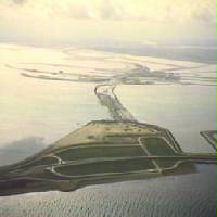
The Oosterscheldekering, between the islands Schouwen-Duiveland and Noord-Beveland, is the largest of the Delta Works, a series of dams and storm surge barriers, designed to protect the Netherlands from flooding from the North Sea. The construction of the Delta Works was a response to the widespread damage and loss of life in the North Sea flood of 1953.

<span class="mw-page-title-main">Deltar</span> Analogue computer used in the Dutch Delta Works project

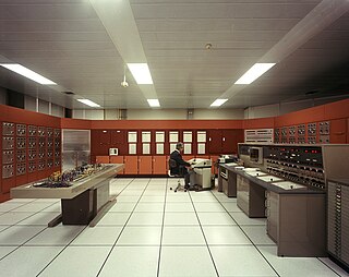
The Deltar was an analogue computer used in the design and execution of the Delta Works from 1960 to 1984. Originated by Johan van Veen, who also built the initial prototypes between 1944 and 1946, its development was continued by J.C. Schönfeld and C.M. Verhagen after van Veen's death in 1959.

The Krammer is a body of fresh water located in the western part of Volkerak in the Netherlands.

<span class="mw-page-title-main">Volkerak</span>

The Volkerak is a body of water in the Netherlands. It is part of the Rhine–Meuse–Scheldt delta, and is situated between the island Goeree-Overflakkee to the north-west and the Dutch mainland to the south and east. The western part of the Volkerak is also called Krammer. Tributaries of the Volkerak are the Dintel and Steenbergse Vliet.

<span class="mw-page-title-main">Oesterdam</span> Compartmentalisation dam in the Netherlands, part of the Delta Works

The Oesterdam is a compartmentalisation dam in The Netherlands, situated between Tholen and South Beveland in the eastern part of the Eastern Scheldt. The dam, with a length of 10.5 kilometres, is the longest structure built for the Delta Works. The Oesterdam was necessitated, like the Philipsdam, after the decision was taken to close off the Eastern Scheldt with a storm surge barrier, rather than a solid dam.

<span class="mw-page-title-main">Markiezaatskade</span> Dam in the Netherlands

The Markiezaatskade is a compartmentalisation dam in The Netherlands, situated between South Beveland and Molenplaat, near Bergen op Zoom. The dam was constructed as part of the Delta Works, and has a length of 4 kilometres.

<span class="mw-page-title-main">Volkerakdam</span> Hydraulic engineering structures in the Netherlands

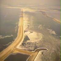
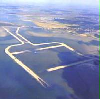
The Volkerakdam or Volkerakwerken is the name given to a group of hydraulic engineering structures located between Goeree-Overflakkee and North Brabant in The Netherlands. The works are not a single dam, but are composed of three distinct structures: a dam between Goeree-Overflakkee and Hellegatsplein, a series of locks from Hellegatsplein to North Brabant, and a bridge from Hellegatsplein to Hoekse Waard. The works cross three separate bodies of water: the Haringvliet, Hollands Diep and Volkerak. The works together comprise the fifth project of the Delta Works.

<span class="mw-page-title-main">Grevelingendam</span> Hydraulic engineering structures in the Netherlands

The Grevelingendam is a dam located in the Grevelingen sea inlet between Schouwen-Duiveland and Goeree-Overflakkee in The Netherlands. The Grevelingendam was the fourth structure constructed as part of the Delta Works.

<span class="mw-page-title-main">Stormvloedkering Hollandse IJssel</span> Hydraulic engineering structure in the Netherlands

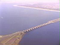
The Stormvloedkering Hollandse IJssel, Hollandse IJsselkering or Algerakering is a storm surge barrier located on the Hollandse IJssel, at the municipal boundary of Capelle aan den IJssel and Krimpen aan den IJssel, east of Rotterdam in The Netherlands. The construction of the works comprised the first project of the Delta Works, undertaken in response to the disastrous effects of the North Sea flood of 1953. Prior to 1954, the spelling Hollandsche was used in the official name.

<span class="mw-page-title-main">Zandkreekdam</span> Hydraulic engineering structures in the Netherlands

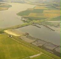
The Zandkreekdam is a compartmentalisation dam located approximately 3 kilometres north of the city of Goes in The Netherlands, which connects Zuid-Beveland with Noord-Beveland, and separates the Oosterschelde from the Veerse Meer.

<span class="mw-page-title-main">Frank Spaargaren</span> Dutch civil engineer

Frank Spaargaren was a Dutch hydraulic engineer who was one of the main designers of the Oosterscheldekering and served as a director of the Waterloopkundig Laboratorium in Delft.

<span class="mw-page-title-main">Jan Agema</span> Dutch Hydraulic Engineer and professor of Civil Engineering

Jan Fokke Agema was a Dutch hydraulic engineer and professor at Delft University of Technology. He is notable for his design of the harbour entrance at Hoek van Holland and involvement in the construction of the Oosterscheldekering. The prof. dr.ir. J.F. Agemaprijs is named for him, and has been awarded every five years since 2000.

A compartmentalisation dam is a dam that divides a body of water into two parts. A typical use of such a dam is the regulation of water levels separately in different sections of a basin. One application of a compartmentalisation dam is to facilitate closures of areas with multiple tidal inlets, such as in the case of the Delta Works.

<span class="mw-page-title-main">Closure of tidal inlets</span>

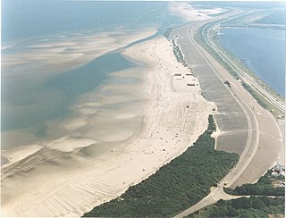
In coastal and environmental engineering, the closure of tidal inlets entails the deliberate prevention of the entry of seawater into inland areas through the use of fill material and the construction of barriers. The aim of such closures is usually to safeguard inland regions from flooding, thereby protecting ecological integrity and reducing potential harm to human settlements and agricultural areas.

References

  1. "Krammersluizen en Philipsdam" [The Krammer Sluices and the Philipsdam]. www.rijkswaterstaat.nl (in Dutch). 29 December 2022. Retrieved 29 December 2022.
  2. 1 2 Compartimenteringswerken [Compartmentalisation Works] (in Dutch). The Hague: Rijkswaterstaat. 1980. Retrieved 4 April 2024.
  3. van Wijngaarden, N.J.; Hartsuiker, G.; Agema, J.F. (1977). Compartimentering Oosterschelde - getijmodel Oosterschelde : onderzoek naar de fasering bij de aanleg van de Philipsdam en de Oesterdam bij gereduceerd getij interim-verslag modelonderzoek [Compartmentalisation of the Eastern Scheldt - Eastern Scheldt tidal model: Research into the phasing during the construction of the Philipsdam and the Oesterdam with reduced tide. Interim report on model research.] (Report) (in Dutch). Rijkswaterstaat . Retrieved 4 April 2024.
  4. 1 2 "Het rapport van de Commissie Compartimentering Oosterschelde" [The Report of the Eastern Scheldt Compartmentalization Commission]. Driemaandelijks bericht Deltawerken (in Dutch). 8e tiental (73): blz 111-114. August 1975. Retrieved 29 March 2024.
  5. 1 2 Watson, I.; Finkl, C. W. (1990). "State of the Art in Storm-Surge Protection: The Netherlands Delta Project". Journal of Coastal Research. 6 (3): 739–764. ISSN   0749-0208. JSTOR   4297737 . Retrieved 29 March 2024.
  6. van Roode, F.C.; Tutuarima, W.H.; Brakel, J.; Groothuizen, A.G.M. (1979). Beschouwing naar aanleiding van "de interimnota nr. 2" : fasering en sluitmethode Compartimenteringsdammen [Reflections on "Interim Note No. 2": Phasing and Closure Method of Compartmentalisation Dams] (Report) (in Dutch). Rijkswaterstaat . Retrieved 4 April 2024.
  7. Huis in 't Veld, J. C.; Stuip, J.; Walther, A.W.; van Westen, J.M. (1987). The Closure of tidal basins: closing of estuaries, tidal inlets, and dike breaches (2nd ed.). Delft, the Netherlands: Delft University Press. ISBN   90-6275-287-X. OCLC   18039440 . Retrieved 29 March 2024.
  8. 1 2 "Philipsdam". WatersnoodMuseum. Stichting Beheer Watersnoodmuseum. Retrieved 9 April 2024.
  9. 1 2 3 4 5 6 "De Regeringsbeslissing over de afsluiting van de Oosterschelde" [The Government Decision on the Closure of the Eastern Scheldt]. Driemaandelijks bericht Deltawerken (in Dutch). 8e tiental (71): blz 3-5. February 1975. Retrieved 29 March 2024.
  10. 1 2 3 4 5 6 Steenhuis, M.; Voerman, L. (2016). De Deltawerken[The Delta Works] (in Dutch). Rotterdam: nai010 uitgevers. ISBN   978-94-6208-272-4.
  11. 1 2 Anonymus, A. (1975). "Driemaandelijks bericht Deltawerken 071-080 (1975-1979)" [Quarterly Bulletin of the Deltaworks 071-080 (1975-1979)]. Driemaandelijks Overzicht van de Deltawerken (Deltaplan) en Gerelateerde Werken (Dijkversterkingen in Holland, Friesland en Groningen, Lauwerszeewerken). Aanleg Stormvloedkeringen Hollandse IJssel en Oosterschelde. Afsluitdammen Met Caissons en Kabelbaan in Veerse Gat, Brouwershavense Gat, Oosterscheldewerken, Spuisluis Haringvliet, Waterhuishouding van het Deltagebied, Milieueffecten. De Secundaire Werken (Vokerak, Grevelingen, Zandkreek, Zoommeer, Philipssluizen, Krammersluizen, Hellegatsplein). Waterloopkundig Onderzoek en Uitvoeringsmethoden. (in Dutch) (71–080). Retrieved 29 December 2022 via TU Delft.
  12. Anonymus, A. (1977). "Driemaandelijks bericht Deltawerken 081-090 (aug 1977-nov 1979)" [Quarterly bulletin of the Delta Works: 081-090 (August 1977-November 1979)]. Quarterly Bulletin of the Delta Works (in Dutch) (81–090). Retrieved 29 December 2022 via TU Delft Repository.
  13. Aanleg werkeiland Philipsdam [Construction of Philipsdam Work Island] (Report) (in Dutch). Hardinxveld, Netherlands: Baggermaatschappij Holland BV.
  14. Baggermaatschappij Holland (1980). Creating an artificial island - Philipsdam. Hardinxveld: Baggermaatschappij Holland. Retrieved 4 April 2024.

Information (in Dutch) about the Philipsdam From the Watersnoodmuseum Knowledge Centre website