A7 motorway (Netherlands)

Last updated

NL-A7.svg
A7 motorway
Rijksweg 7
Rijksweg7.svg
Location of the A7 motorway
Route information
Part of NL-E22.svg E22
Major junctions
West end NL-A8.svg A8 in Zaandam
East end Bad Nieuweschans
Bundesautobahn 280 number.svg A 280 border with Germany
Location
Country Kingdom of the Netherlands
Constituent country Netherlands
Highway system

The A7 motorway is a motorway in the Netherlands connecting Zaandam, via the Afsluitdijk, Sneek and Groningen to the German border near Bad Nieuweschans. The entire road is part of the European route E22, with exception of the first kilometer, between the terminus in Zaandam and the interchange Zaandam. The total length is 236 km.

Contents

Motorway interruptions

The motorway A7 is interrupted twice:

Both of the abovementioned sections are denoted as N7 to distinguish those parts from the motorway, for which the A designation is used in the Netherlands. The A7 together with the N7 is called the Rijksweg 7.

Westbound N7 near Groningen. A7-groningen-tijnje-004.jpg
Westbound N7 near Groningen.
Interruption of the A7 in Groningen. Julianaplein w.jpg
Interruption of the A7 in Groningen.

Speed limit experiment

The A7 runs under the Duvelsrak viaduct in Sneek Duvelsrak viaduct.JPG
The A7 runs under the Duvelsrak viaduct in Sneek

From March 2011, on a section of the A7 motorway, motorists were allowed to drive at 130 km/h (80 mph), opposed to the then national speed limit of 120 km/h (75 mph). This was a government test to investigate if driving at these higher speeds have an effect on the environment and safety. The test resulted positively, and the national speed limit was raised to 130 km/h (80 mph) in October 2012.

Afsluitdijk

The A7 runs across a historic part of Dutch engineering, the Afsluitdijk. This dam was originally created to protect the country's long interior coastline from floods by creating a large freshwater lake. The road over the Afsluitdijk was previously a 2-lane N road, but is now a proper motorway; the upgrade to motorway was achieved by utilising the dike's unused railway reservation for the second carriageway. Its midpoint is near the village of Breezanddijk. The former State Secretary for Infrastructure and the Environment, Joop Atsma, issued a statement detailing the factors influencing the decision to build a new naviduct on the Afsluitdijk section of the A7 at Kornwerderzand. A naviduct and new locks was costed at €200–450 million, depending on the size of locks and size of highway. A naviduct would give waiting time annualised benefits €13 million to road traffic, based on the existing bridge opening 7,000 times a year. Cost–benefit analysis of all potential solutions were considered, and a naviduct could be built to replace the locks when they reach the end of their useful life in 2050. [1]

Exit list

CountryProvinceMunicipalitykmmiExitDestinationsNotes
Netherlands North Holland Zaanstad 42.5NLD-S151.svgNLD-S155.svg S 151 west / S 155
53.1NL-A8.svgNL-E22.svg A 8  / E22 northeastWest end of E 22 overlap
74.32NLD-N515.svg N 515 west
Wormerland 116.83Oosterdwarsweg
Purmerend 148.74Laan der Continenten
159.35NLD-N235.svg N 235 east / Zuiddijk
17116NLD-N244.svg N 244
Koggenland 29187NLD-N243.svgNLD-N247.svg N 243 southwest / N 247 south
Hoorn 32208Provincialeweg
34219NLD-N307.svg N 307 east (Westfrisiaweg)
Medemblik 362210NLD-N241.svg N 241 west (A.C. de Graafweg) / Tender
392410aTuinstraat / Broerdijk
432711NLD-N239.svg N 239 (Dijkweg)
Wieringermeer 503112NLD-N242.svg N 242 southwest (Alkmaarseweg)
553413NLD-N240.svgNLD-N248.svg N 240 west and south / N 248 south
Wieringen 644014NLD-N99.svg N 99 southwest (Rijksstraatweg)
IJsselmeer / Wadden Sea Afsluitdijk
Friesland Súdwest Fryslân 10163NL-A31.svg A 31
1016315
1056516Weersterweg
1106817NLD-N359.svg N 359  / Oude Rijksweg
1127018Kloosterlaan
1157119Tsjaerddyk / Hottingawei
1187320State AsWest end of N7 road designation
1197421NLD-N354.svg N 354 south (Lemmerweg) / Lemmerweg
1197421aAkkenwinde / SelfhelpwegWestbound exit and eastbound entrance only
1207522NLD-N354.svg N 354 northeast / Oppenhuizerweg / Lorentzstraat / Burgemeester RasterhofflaanEast end of N7 road designation
Skarsterlân 1338323Woudfennen
13685NL-A6.svg A 6 southwest / Geert Knolweg
1408725De Dolten / Nije Fjildwei
Heerenveen 1428826Wetterwille / Weinmakker / Nije FjildweiWestbound exit and eastbound entrance only
14489NL-A32.svg A 32
1479126aZestienroeden / Pastoriesingel
Opsterland 1529427NLD-N392.svg N 392 (Koaibosk)
1589828Beetserweg
Smallingerland 16110029Zuiderhogeweg
16510330NLD-N381.svg N 381 south
16510330aNLD-N31.svg N 31 northwest
Opsterland 17011031NLD-N358.svg N 358 northwest (De Scheiding) / De Scheiding
Groningen Marum 17610932NLD-N980.svg N 980 north (Noorderweg) / Noorderweg / Noorderringweg / Parallelweg
18011033NLD-N388.svg N 388 north (Boerakkerweg) / Boerakkerweg
Leek 18411434NLD-N372.svgNLD-N978.svg N 372 south (Oude Postweg) / N 978 north (Oude Postweg) / Pasop / Blinkweg / Lage Traan / Kapteynlaan
Groningen 19111934aWestpoortboulevard / MatslootSouthern exit lies partially in Noordenveld, Drenthe
19312035NLD-N372.svg N 372 south (Ruskenveen) / Zuiderweg / Roderwolderdijk
19612236NLD-N370.svg N 370 north (Laan 1940-1945) / Jan Evert Scholtenlaan / Laan Corpus Den Hoorn / Paterswoldseweg / MuntinglaanWest end of N7 road designation
19612236aNLD-N370.svg N 370 northWestbound entrance only
197122NL-E232.svgNL-A28.svg E232 south (Julianaweg) / A 28  / Emmaviaduct / Hoornsediep
19812337Hereweg
19812337aMeeuwerderbaan / Europaweg / WinschoterdiepWestbound entrance and eastbound exit only
19912438Europaweg / Bergenweg / Lübeckweg / Osloweg / Euvelgunnebrug / Gotenburgweg / Kieler Bocht / Skagerrak
204127NLD-N46.svg N 46 northwest (Beneluxweg)
20512739EuropawegEast end of N7 road designation
Hoogezand-Sappemeer 21313240NLD-N386.svg N 386 southwest (Rengerslaan) / Rengerslaan / A.B. Nobellaan
21513441NLD-N385.svgNLD-N387.svg N 385 south (Kerkstraat) / N 387 north (Provinciale Weg) / Rijksweg West / Rijksweg Oost / Knijpslaan
21813542Noordbroeksterstraat / Rijksweg oost
Menterwolde 22213843Kerkstraat / Europaweg / Burgemeester Omtaweg
22413944NLD-N33.svg N 33
Oldambt 23014045NLD-N362.svg N 362 north (Rijksweg) / Rijksweg
23214446NLD-N964.svg N 964 south
24015047NLD-N367.svgNLD-N966.svgNLD-N967.svg N 367 south (Oostereinde) / N 966 northeast (Oostereinde) / N 967 north
24615348 Ulsda / Ulsderweg / Heeresloot
25115649Hamdijk
Netherlands / Germany
country line
Groningen / Lower Saxony
province line
Reiderland / Bunde
municipality line
European Road 22 number DE.svgBundesautobahn 280 number.svg E22  / A 280 eastBorder with Germany; this road continues as the German A280; east end of E 22 overlap
1.000 mi = 1.609 km; 1.000 km = 0.621 mi

Related Research Articles

<span class="mw-page-title-main">Speed limit</span> Maximum legal speed of vehicles

Speed limits on road traffic, as used in most countries, set the legal maximum speed at which vehicles may travel on a given stretch of road. Speed limits are generally indicated on a traffic sign reflecting the maximum permitted speed – expressed as kilometres per hour (km/h) and/or miles per hour (mph). Speed limits are commonly set by the legislative bodies of national or provincial governments and enforced by national or regional police and judicial authorities. Speed limits may also be variable, or in some places nonexistent, such as on most of the Autobahnen in Germany.

<i>Afsluitdijk</i> Dam

The Afsluitdijk is a major dam and causeway in the Netherlands. It was constructed between 1927 and 1932 and runs from Den Oever in North Holland province to the village of Zurich in Friesland province, over a length of 32 kilometres (20 mi) and a width of 90 metres (300 ft), at an initial height above Amsterdam Ordnance Datum of between 6.7 metres (22 ft) along the section at Friesland, and 7.4 metres (24 ft) where it crosses the deep channel of the Vlieter. The height at the greater sea depths west of Friesland was required to be a minimum of 7 metres everywhere when originally constructed.

<span class="mw-page-title-main">Dual carriageway</span> Type of road

A dual carriageway (BrE) or a divided highway (AmE) is a class of highway with carriageways for traffic travelling in opposite directions separated by a central reservation (BrE) or median (AmE). Roads with two or more carriageways which are designed to higher standards with controlled access are generally classed as motorways, freeways, etc., rather than dual carriageways.

<span class="mw-page-title-main">Limited-access road</span> High-speed road with many characteristics of a controlled-access highway (freeway or motorway)

A limited-access road, known by various terms worldwide, including limited-access highway, dual-carriageway, expressway, limited-access freeway, and partial controlled-access highway, is a highway or arterial road for high-speed traffic which has many or most characteristics of a controlled-access highway, including limited or no access to adjacent property, some degree of separation of opposing traffic flow, use of grade separated interchanges to some extent, prohibition of slow modes of transport, such as bicycles, (draught) horses, or self-propelled agricultural machines; and very few or no intersecting cross-streets or level crossings. The degree of isolation from local traffic allowed varies between countries and regions. The precise definition of these terms varies by jurisdiction.

<span class="mw-page-title-main">Autostrade of Italy</span> National Motorway System of Italy

The Autostrade are roads forming the Italian national system of motorways. The total length of the system is about 6,758 kilometres (4,199 mi). In North and Central Italy, the Autostrade mainly consists of tollways managed by Autostrade per l'Italia, a holding company controlled by Cassa Depositi e Prestiti. Other operators include ASTM, ATP, and Autostrade Lombarde in the north-west; Autostrada del Brennero, A4 Holding, Concessioni Autostradali Venete, and Autovie Venete in the north-east; Strada dei Parchi, SALT, SAT, and Autocisa in the center; and CAS in the south.

<span class="mw-page-title-main">Autobahn</span> National expressway in Germany

The Autobahn is the federal controlled-access highway system in Germany. The official German term is Bundesautobahn, which translates as 'federal motorway'. The literal meaning of the word Bundesautobahn is 'Federal Auto(mobile) Track'.

<span class="mw-page-title-main">Controlled-access highway</span> Highway with regulated traffic flow

A controlled-access highway is a type of highway that has been designed for high-speed vehicular traffic, with all traffic flow—ingress and egress—regulated. Common English terms are freeway, motorway and expressway. Other similar terms include throughway and parkway. Some of these may be limited-access highways, although this term can also refer to a class of highways with somewhat less isolation from other traffic.

<span class="mw-page-title-main">Highways in Hungary</span> Numbered system of roads in Hungary

Controlled-access highways in Hungary are dual carriageways, grade separated with controlled-access, designed for high speeds. The legislation amendments define two types of highways: motorways and expressways.

<i>Bundesstraße</i> German and Austrian national highways

Bundesstraße, abbreviated B, is the denotation for German and Austrian national highways.

<span class="mw-page-title-main">A28 motorway (Netherlands)</span> Road connecting Utrecht and Groningen

The A28 motorway is a motorway in the Netherlands. It is approximately 188 kilometers in length.

<span class="mw-page-title-main">A5 motorway (Netherlands)</span>

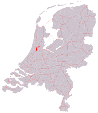
The A5 motorway is a motorway in the Netherlands. With a length of 17 kilometres (11 mi), it is one of the shortest motorways in the country.

<span class="mw-page-title-main">A2 motorway (Netherlands)</span> Highway in the Netherlands

The A2 motorway is a motorway in the Netherlands. It is one of the busiest highways in the Netherlands. The road connects the city of Amsterdam, near the Amstel interchange with the Belgian border, near Maastricht (NL) and Liège (B), and the Belgian A25 road.

<span class="mw-page-title-main">A16 motorway (Netherlands)</span>

The A16 motorway is a motorway in the Netherlands. It runs from the interchange Terbregseplein in the northeastern part of Rotterdam, towards the Belgian border near Hazeldonk. The motorway has 19 exits including 7 interchanges.

<span class="mw-page-title-main">A20 motorway (Netherlands)</span>

The A20 motorway is a motorway in the Netherlands. It is approximately 39 kilometers in length.

<span class="mw-page-title-main">A58 motorway (Netherlands)</span>

The A58 motorway is a motorway in the Netherlands. It is approximately 145 kilometres in length. The A58 is located in the Dutch provinces of North Brabant and Zeeland.

<span class="mw-page-title-main">A31 motorway (Netherlands)</span> Motorway in Friesland

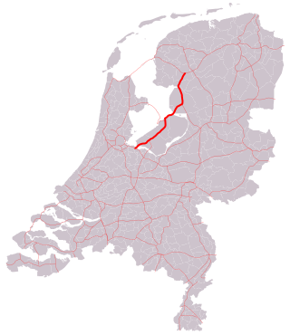
The A31 / N31 is a motorway and an expressway in the Netherlands. It connects the A7 near Zurich with the A7 near Drachten, passing close to Leeuwarden, the provincial capital. It is slightly unusual due to it changing from full motorway to normal 2-lane road along various sections of its 65 km length.

This article describes the highway systems available in selected countries.

<span class="mw-page-title-main">Roads in Hungary</span>

Hungarian road categories are as follows:

<span class="mw-page-title-main">Naviduct</span>

A naviduct is a special class of navigable aqueduct, in which the waterway also includes a lock. One example of a naviduct has been built at Enkhuizen on the Houtribdijk in the Netherlands on the instructions of the Rijkswaterstaat. This cost over €55 million and was completed in 2003. It is big enough to simultaneously transfer two large Rhine river-barges from the Markermeer to the IJsselmeer or vice versa. The structure was chosen because a busy waterway crosses a dam carrying a busy road, but the space available for separate aqueduct and lock facilities was restricted.

<span class="mw-page-title-main">European route E22 in the Netherlands</span>

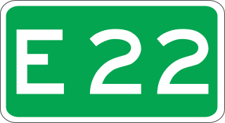
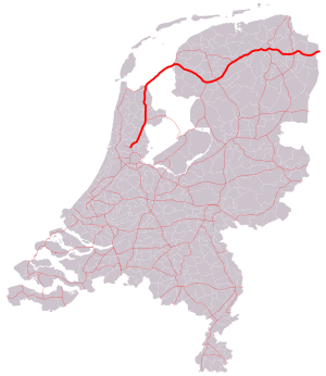
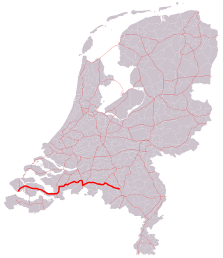
European route E 22 (E 22) is a west–east European route, running from Holyhead in the United Kingdom, through the Netherlands, Germany, Sweden and Latvia, to Ishim in Russia.

References

  1. Atsma, Joop (3 July 2012). "Toezegging naviduct Afsluitdijk" (PDF) (in Dutch). Ministerie van Infrastructuur en Milieu. Retrieved 2 August 2013.

Commons-logo.svg Media related to Rijksweg 7 at Wikimedia Commons