Overview
Here one drives approximately two kilometers south by means of the combined A9/A2 before the A9 heads off to the west again towards Amstelveen, junction 'Badhoevedorp' (A4), junction 'Raasdorp' (A5), junction 'Rottepolderplein' (A200) and on to junction 'Velsen' (A22). Hereafter, the A9 goes further northward by means of the Wijkertunnel under the North Sea Canal, junction 'Beverwijk' (A22) to Alkmaar. At this point, the A9 motorway becomes the N9 highway and proceeds until De Kooy (at Den Helder).
In 1996, the Wijkertunnel was opened and integrated into the A9. The original route of the A9 ran through the Velsertunnel where there is also a connection with the A208. This part still exists but this portion of motorway has been re-numbered to A22.
The part between A1 and A2 is four lanes; between A2 and Rottepolderplein it is six lanes. Hereafter the way is mainly four lanes, with short pieces in the area of the Wijkertunnel that are six lanes.
With regard to the Gaasperdammerweg, it is noted in the original plans that this road would not become a motorway. The plan was to build a local link-road for the occupants of the Bijlmermeer. The section between A2/A9 and A1/A6 was never built, although this would have formed a natural connection between A9 and A6. Because of this, the Gaasperdammerweg has developed into an overflowing connection between A2 and A1.
Discussions on extending the A9 in a straight line to the A6 are still going on. Because this part of the route would pass by the Naardermeer, environmentalists oppose this plan.
The A1, also known as the Great North Road, is the longest numbered road in the United Kingdom, at 410 miles (660 km). It connects London, the capital of England, with Edinburgh, the capital of Scotland. The numbering system for A-roads, devised in the early 1920s, was based around patterns of roads radiating from two hubs at London and Edinburgh. The first number in the system, A1, was given to the most important part of that system: the road from London to Edinburgh, joining the two central points of the system and linking the UK's (then) two mainland capital cities. It passes through or near north London, Hatfield, Stevenage, Baldock, Biggleswade, Peterborough, Stamford, Grantham, Newark-on-Trent, Retford, Doncaster, Pontefract, York, Wetherby, Ripon, Darlington, Durham, Gateshead, Newcastle upon Tyne, Morpeth, Alnwick, Berwick-upon-Tweed, Dunbar, Haddington, Musselburgh, and east Edinburgh.

In Great Britain, there is a numbering scheme used to classify and identify all roads. Each road is given a single letter and a subsequent number. Though this scheme was introduced merely to simplify funding allocations, it soon became used on maps and as a method of navigation. There are two sub-schemes in use: one for motorways, and another for non-motorway roads.

The National Roads and Motorways in Greece constitute the main road network of the country. These two types of roads are distinct in terms of their construction specifications. Their main difference is that motorways adhere to higher quality construction standards than National Roads.

The A66 is a major road in Northern England, which in part follows the course of the Roman road from Scotch Corner to Penrith. It runs from east of Middlesbrough in North Yorkshire to Workington in Cumbria. The road has been progressively improved with dual carriageway sections, but with stretches of single carriageway road. The road is set to be completely dualled between Scotch Corner and Penrith, with a £1.3 billion scheme being announced in March 2024.

Controlled-access highways in Poland are part of the national roads network and they are divided into motorways and expressways. Both types of highways feature grade-separated interchanges with all other roads, emergency lanes, feeder lanes, wildlife crossings and dedicated roadside rest areas. Motorways differ from expressways in their technical parameters like designated speed, permitted road curvature, lane widths or minimal distances between interchanges. Moreover, expressways might have single-carriageway sections in case of low traffic densities.
The Randstad is a roughly crescent- or arc-shaped conurbation in the Netherlands, that includes almost half the country's population. With a central-western location, it connects and comprises the Netherlands' four biggest cities, their suburbs, and many towns in between, that all grew and merged into each other. Among other things, it includes the Port of Rotterdam, the Port of Amsterdam, and Amsterdam Airport Schiphol. With a population of approximately 8.4 million people it is one of the largest metropolitan regions in Europe,[b] comparable in population size to the Rhine-Ruhr metropolitan region or the San Francisco Bay Area, and covers an area of approximately 11,372 km2 (4,391 sq mi).[a] The Randstad had a gross regional domestic product of €510 billion in 2022, making it the second most productive region in the European Union, only behind the Paris metropolitan area. It encompasses both the Amsterdam metropolitan area and Rotterdam–The Hague metropolitan area. It is part of the larger Blue Banana megalopolis.

Bundesautobahn 1 is an autobahn in Germany. It runs from Heiligenhafen in Schleswig-Holstein to Saarbrücken, a distance of 749 km (465 mi), but is incomplete between Cologne and Trier. B 207 continues north from Heiligenhafen to Puttgarden, at the end of the island of Fehmarn, with a ferry to Rødby, Denmark.

A controlled-access highway is a type of highway that has been designed for high-speed vehicular traffic, with all traffic flow—ingress and egress—regulated. Common English terms are freeway, motorway, and expressway. Other similar terms include throughway or thruway and parkway. Some of these may be limited-access highways, although this term can also refer to a class of highways with somewhat less isolation from other traffic.

Bundesautobahn 10 is an orbital motorway around the German capital city of Berlin. Colloquially called Berliner Ring , it is predominantly located in the state of Brandenburg, with a short stretch of 5 km in Berlin itself. It should not be confused with the Berliner Stadtring around Berlin's inner city.
Switzerland has a two-class highway system: motorways with separated roads for oncoming traffic and a standard maximal speed limit of 120 kilometres per hour (75 mph), and expressways often with oncoming traffic and a standard maximal speed limit of 100 kilometres per hour (62 mph).

The motorways in North Macedonia are called avtopat and the name, like its translation in most languages, simply means auto road.
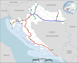
Highways in Croatia are the main transport network in Croatia. The Croatian classification includes several classes of highways:

The A22 motorway is a motorway in the Netherlands. It is one of the shorter motorways in the Netherlands, with a total length of approximately 8 kilometers.

Motorways in Serbia are called auto-put, a name which simply means car-road. Roads that are motorways are categorized as state roads of IA category and are marked with one or two digit numbers. Motorways in Serbia have three lanes in each direction, signs are white-on-green, and the normal speed limit is 130 km/h (81 mph). They are maintained and operated by the national road operator company JP "Putevi Srbije".
There are 28 routes assigned to the "A" zone of the California Route Marker Program, which designates county routes in California. The "A" zone includes county highways in Lassen, Plumas, Shasta, Siskiyou, and Tehama counties.
The A9 highway is a major highway in Nigeria, located in the northern region of the country. It serves as a vital transportation link, connecting several key cities and facilitating both domestic and international trade.

The Autostrada A22 or Autobrennero or Autostrada del Brennero is one of the most important autostrada in Italy, as it connects Po Valley, the city of Modena and the Autostrada A1 to Austria through the Brenner Pass, located in the municipality of Brenner. The Autostrada A22 is 315 kilometres (196 mi) long. It is a part of the E45 European route. The operator of the road is Autostrada del Brennero S.p.A.. The Autostrada A22 is located in the regions of Emilia-Romagna, Lombardy, Veneto and Trentino-Alto Adige/Südtirol.

State Road 23, from Čačak via Zlatibor commonly known as Zlatibor Highway, is an IB-class road in central and western Serbia, connecting Pojate with Montenegro at Gostun. It is located in Šumadija and Western Serbia.

