A27 motorway (Netherlands)

Last updated

NL-A27.svg
A27 motorway
Rijksweg 27
Rijksweg27.svg
Motorways in the Netherlands with the Rijksweg 27 part in bold
Route information
Part of NL-E312.svgNL-E311.svgNL-E30.svg E312  / E311  / E30
Maintained by Rijkswaterstaat [1]
Major junctions
South endNL-E19.svgNL-E312.svgNL-A16.svgNL-A58.svg E19  / E312  / A 16  / A 58 near Breda
Major intersections
North endNL-A6.svg A 6 in Almere
Location
Country Kingdom of the Netherlands
Constituent country Netherlands
Provinces North Brabant, South Holland, Utrecht, North Holland, Flevoland
Highway system
NL-A22.svg A 22 NL-A28.svg A 28

The A27 motorway is a motorway in the Netherlands. It is approximately 109 kilometers in length.

Contents

The A27 is located in the Dutch provinces North Brabant, South Holland, Utrecht, North Holland, and Flevoland. It connects the city of Breda with Almere. On its way, it passes the cities of Gorinchem, Utrecht and Hilversum.

Reference to A58 and A27 on the A16. E312 bord.jpg
Reference to A58 and A27 on the A16.
The A27 near Hilversum. A27 Hilversum.jpg
The A27 near Hilversum.

Route description

'Shared section' with A58 motorway

Although not officially a part of the Rijksweg 27, the section of the A58 motorway between interchanges Galder and Sint-Annabosch is also being referred to as A27, next to the road's official reference number A58.

Technically this situation is incorrect, since the A27's official start is only at interchange Sint-Annabosch. However, the reference A27 has probably been added to the road signs to help traffic coming from Antwerp in finding their way from the A16 / E19 towards the A27.

European routes

No major European routes follow the A27 motorway. The only one to follow it, is the E311 road between interchange Sint-Annabosch near Breda and interchange Lunetten near Utrecht. This section of the A27 immediately comprises the entire E311 road, since it does not follow any other roads.

Besides, the 'shared section' with the A58 is part of the European route E312.

History

The northernmost section, connecting the town of Huizen with Almere, has been opened in 1999.

Exit list

ProvinceMunicipalitykmmiExitDestinationsNotes
North Brabant Breda NL-E19.svgNL-E312.svgNL-A16.svgNL-A58.svg E19  / E312  / A 16  / A 58 West end of A58 and E 312 overlap
14NLD-N639.svg N 639 southeast (Chaamsebaan) / Chaamsebaan
NL-E311.svgNL-E312.svgNL-A58.svg E311  / E312  / A 58 East end of A58 and E 312 overlap; south end of E 311 overlap
15Franklin Rooseveltlaan
16NLD-N282.svg N 282 east (Tilburgseweg) / Tilburgseweg
Oosterhout 17NLD-N631.svg N 631 southeast (Vijf Eikenweg) / Europaweg
18Wilhelminakanaal NoordNorthbound entrance and southbound exit only
19NLD-N629.svg N 629 southeast (Ekelstraat) / Bovensteweg
Geertruidenberg NL-A59.svg A 59
20Maasdijk / Keizersveer
Werkendam 21NLD-N283.svg N 283 east (Provincialeweg) / Provincialeweg / Keizer Napoleonweg / Keizersveer / Kurenpolderweg
22NLD-N322.svg N 322 east (Zevenbanseweg / Doornseweg) / Zevenbanseweg / Doornseweg
23Tol
South Holland Gorinchem 24Nieuwe Wolpherensedijk
NL-E31.svgNL-A15.svg E31  / A 15
Giessenlanden 25NLD-N214.svg N 214 west / Zijlkade / Parallelweg
Zederik 26Lakerveld
Utrecht Vianen NL-E25.svgNL-A2.svg E25  / A 2
27Hagenweg / Ingenieur D.S. Tuijnmanweg
Nieuwegein 28Waterliniedok / De Kroon
Houten 29De Staart
Utrecht NL-E30.svgNL-E35.svgNL-E311.svgNL-A12.svg E30  / E35  / E311 south / A 12 North end of E 311 overlap; south end of E 30 overlap
NL-E30.svgNL-A28.svg E30  / A 28 North end of E 30 overlap
30Blitse Rading
31NLD-N230.svg N 230 northwest
De Bilt 32NLD-N234.svgNLD-N417.svg N 234 east (Nieuwe Weteringseweg) / N 417 northeast (Koningin Wilhelminaweg)
North Holland Hilversum 33Diependaalselaan / Oostereind
Utrecht Eemnes NL-E231.svgNL-A1.svg E231  / A 1
34Verlegde Laarderweg / Zuidersingel
North HollandUtrecht
province line
Huizen 35Randweg Oost / Stichtseweg
Flevoland Almere 36NLD-N305.svg N 305 (Gooiseweg / Waterlandseweg)
37NLD-N706.svg N 706 (Vogelweg)
NL-A6.svg A 6
1.000 mi = 1.609 km; 1.000 km = 0.621 mi

See also

Related Research Articles

The Randstad is a roughly crescent- or arc-shaped conurbation in the Netherlands, that includes almost half the country's population. With a central-western location, it connects and comprises the Netherlands' four biggest cities, their suburbs, and many towns in between, that all grew and merged into each other. Among other things, it includes the Port of Rotterdam, the Port of Amsterdam, and Amsterdam Airport Schiphol. With a population of approximately 8.4 million people it is one of the largest metropolitan regions in Europe,[b] comparable in population size to the Rhine-Ruhr metropolitan region or the San Francisco Bay Area, and covers an area of approximately 11,372 km2 (4,391 sq mi).[a] The Randstad had a gross regional domestic product of €510 billion in 2022, making it the second most productive region in the European Union, only behind the Paris metropolitan area. It encompasses both the Amsterdam metropolitan area and Rotterdam–The Hague metropolitan area. It is part of the larger Blue Banana megalopolis.

<span class="mw-page-title-main">Breda</span> City and municipality in North Brabant, Netherlands

Breda is a city and municipality in the southern part of the Netherlands, located in the province of North Brabant. The name derived from brede Aa and refers to the confluence of the rivers Mark and Aa. Breda has 185,072 inhabitants on 13 September 2022 and is part of the Brabantse Stedenrij; it is the ninth largest city/municipality in the country, and the third largest in North Brabant after Eindhoven and Tilburg. It is equidistant from Rotterdam and Antwerp.

<span class="mw-page-title-main">A4 motorway (Netherlands)</span> Highway in the Netherlands

The A4 motorway, also called Rijksweg 4, is a motorway in the Netherlands running southwards from Amsterdam to the Belgian border near Zandvliet, north of the city of Antwerp. The 119-kilometre-long (74 mi) A4 is divided into two sections; the first and longer section runs from Amsterdam to the A15 near the city of Rotterdam, while the second section starts near Heijningen, where the A29 and the A4 meet, going to the Belgian border.

<span class="mw-page-title-main">A28 motorway (Netherlands)</span> Road connecting Utrecht and Groningen

The A28 motorway is a motorway in the Netherlands. It is approximately 188 kilometers in length.

<span class="mw-page-title-main">A6 motorway (Netherlands)</span> Motorway in the Netherlands

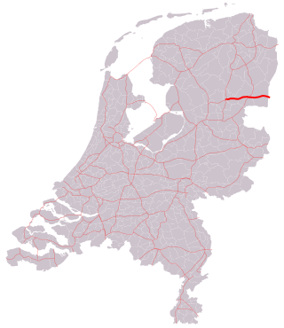
The A6 motorway is a motorway in the Netherlands. It is just over 100 kilometers in length and it connects the A1 motorway at interchange Muiderberg with the A7 motorway at interchange Joure.

<span class="mw-page-title-main">A1 motorway (Netherlands)</span> Highway in the Netherlands

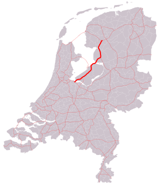
The A1 is a motorway in the Netherlands. The road connects the capital city of Amsterdam, near the interchange of Watergraafsmeer, with the German border, near Oldenzaal and Bad Bentheim, and the German Autobahn BAB 30. On its way, it crosses four provinces: North Holland, Utrecht, Gelderland and Overijssel.

<span class="mw-page-title-main">A2 motorway (Netherlands)</span> Highway in the Netherlands

The A2 motorway is a motorway in the Netherlands. It is one of the busiest highways in the Netherlands. The road connects the city of Amsterdam, near the Amstel interchange with the Belgian border, near Maastricht (NL) and Liège (B), and the Belgian A25 road.

<span class="mw-page-title-main">A12 motorway (Netherlands)</span> Motorway in the Netherlands

The A12 motorway is a motorway in the Netherlands. The road connects the city of The Hague with the German border, near Zevenaar, and the German Autobahn BAB 3. On its way, it crosses three Dutch provinces: South Holland, Utrecht, and Gelderland.

<span class="mw-page-title-main">A13 motorway (Netherlands)</span> Freeway in the Netherlands

The A13 motorway is a motorway in the Netherlands, connecting the cities of The Hague and Rotterdam. The Rotterdam The Hague Airport is located next to the A13.

<span class="mw-page-title-main">A16 motorway (Netherlands)</span> Freeway in the Netherlands

The A16 motorway is a motorway in the Netherlands. It runs from the interchange Terbregseplein in the northeastern part of Rotterdam, towards the Belgian border near Hazeldonk. The motorway has 19 exits including 7 interchanges.

<span class="mw-page-title-main">A17 motorway (Netherlands)</span> Freeway in the Netherlands

The A17 motorway is a motorway in the Netherlands. It runs from the interchange Klaverpolder, just south of the Moerdijk bridge in the A16 motorway, towards the interchange De Stok with the A58 motorway, near Roosendaal.

<span class="mw-page-title-main">A20 motorway (Netherlands)</span> Freeway in the Netherlands

The A20 motorway is a motorway in the Netherlands. It is approximately 39 kilometers in length.

<span class="mw-page-title-main">A37 motorway (Netherlands)</span> Motorway connecting Hoogeveen with Emmen and the German border near Zwartemeer

The A37 motorway is a motorway in the Netherlands. It is approximately 42 kilometers in length. The A37 is located entirely in the Dutch province of Drenthe.

<span class="mw-page-title-main">A58 motorway (Netherlands)</span> Freeway in the Netherlands

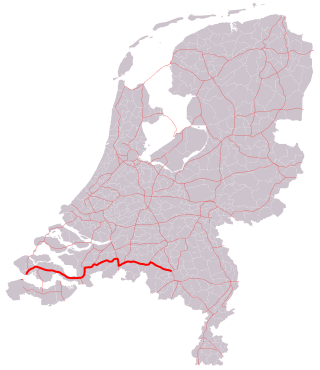
The A58 motorway is a motorway in the Netherlands. It is approximately 145 kilometres in length. The A58 is located in the Dutch provinces of North Brabant and Zeeland.

<span class="mw-page-title-main">A67 motorway (Netherlands)</span> Motorway in the Netherlands

The A67 motorway is a motorway in the Netherlands. It is located in the Dutch provinces of North Brabant and Limburg.

<span class="mw-page-title-main">European route E231</span> Road in trans-European E-road network

The E 231 is a European B class road in the Netherlands, connecting the cities of Amsterdam and Amersfoort.

<span class="mw-page-title-main">European route E312</span> Road in trans-European E-road network

E 312 is a European B class road in the Netherlands, connecting the cities of Flushing (Vlissingen) and Eindhoven.

<span class="mw-page-title-main">European route E311</span> Road in trans-European E-road network

E 311 is a European B class road in Netherlands, connecting the cities of Utrecht and Breda.

<span class="mw-page-title-main">Rijksstraatweg</span>

Rijksstraatweg or simply Straatweg was the term for paved roads of interregional significance in the Netherlands in the 19th and early 20th centuries. These roads were built by the national government, and formed the country's first centrally planned highway network. They received route numbers, eventually resulting in a nationwide network of 82 highways. It formed the basis for today's system of nationally controlled roads, the Netherlands' main highway grid.

<span class="mw-page-title-main">European route E35 in the Netherlands</span>

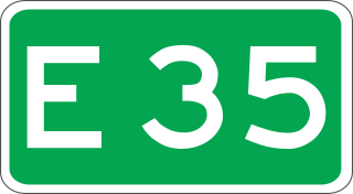
European route E 35 (E 35) is a north–south European route, running from Amsterdam in the Netherlands to Rome in Italy. In the Netherlands, the highway runs from its northern terminus in Amsterdam eastwards through Utrecht and Arnhem to the German border, near Zevenaar. The road runs concurrently with three other motorways over its entire length, starting on Rijksweg 10 (A10) around Amsterdam, then A2 from southern Amsterdam up to Utrecht, and the last part on A12 until it reaches the German border in the east.

References

  1. "Wegbeheerders". Rijkswaterstaat. Retrieved 14 December 2014.

Commons-logo.svg Media related to Rijksweg 27 at Wikimedia Commons