Bundesautobahn 3 is an autobahn in Germany running from the Germany-Netherlands border near Wesel in the northwest to the Germany-Austria border near Passau.

A controlled-access highway is a type of highway that has been designed for high-speed vehicular traffic, with all traffic flow—ingress and egress—regulated. Common English terms are freeway, motorway, and expressway. Other similar terms include throughway or thruway and parkway. Some of these may be limited-access highways, although this term can also refer to a class of highways with somewhat less isolation from other traffic.

Bundesautobahn 4 is an autobahn in two discontinuous segments that crosses Germany in a west–east direction. The western segment has a length of 156 km (97 mi), while the part in the east is 429 km (267 mi) long.
A two-lane expressway or two-lane freeway is an expressway or freeway with only one lane in each direction, and usually no median barrier. It may be built that way because of constraints, or may be intended for expansion once traffic volumes rise. The term super two is often used by roadgeeks for this type of road, but traffic engineers use that term for a high-quality surface road. Most of these roads are not tolled.
The A3 motorway is a major motorway in Croatia spanning 306.5 kilometres (190.5 mi). The motorway connects Zagreb, the nation's capital, to the historical Slavonia region of Croatia and a number of cities along the Sava River. It represents a major east–west transportation corridor in Croatia and a significant part of the Pan-European Corridor X, serving as a transit route between the European Union states and the Balkans. Apart from Zagreb, where the A3 motorway comprises a considerable part of the Zagreb bypass, the motorway runs near a number of significant Croatian cities.

The A4 motorway, also called Rijksweg 4, is a motorway in the Netherlands running southwards from Amsterdam to the Belgian border near Zandvliet, north of the city of Antwerp. The 119-kilometre-long (74 mi) A4 is divided into two sections; the first and longer section runs from Amsterdam to the A15 near the city of Rotterdam, while the second section starts near Heijningen, where the A29 and the A4 meet, going to the Belgian border.

The Autostrada A26 is an autostrada 197.1 kilometres (122.5 mi) long in Italy located in the regions of Liguria and Piedmont. It is named the Autostrada dei Trafori after the numerous tunnels through which it passes, both Apennine and Subalpine. It runs northwards from Genoa on the Ligurian coast, over the Apennines, and across the wide plain of the Po valley to the environs of Lake Maggiore and the mouth of the Val d’Ossola. In addition to this ‘main trunk’ of the road, there are three side branches, also of motorway class which function as link roads between the A26 and the A7, the A4 and the A8. The A26, together with these link roads, is managed by Autostrade per l'Italia S.p.A. It is a part of the E25 and E62 European routes.

The European route E314 is a road in Europe and a part of the United Nations International E-road network. Approximately 125 kilometers (78 mi) long, it connects the Belgian university city of Leuven with Aachen, Charlemagne's capital during the early ninth century, and today a bustling commercial centre in Germany's North Rhine-Westphalia.

The A2 motorway is a motorway in the Netherlands. It is one of the busiest highways in the Netherlands. The road connects the city of Amsterdam, near the Amstel interchange with the Belgian border, near Maastricht (NL) and Liège (B), and the Belgian A25 road.

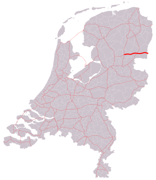
The A12 motorway is a motorway in the Netherlands. The road connects the city of The Hague with the German border, near Zevenaar, and the German Autobahn BAB 3. On its way, it crosses three Dutch provinces: South Holland, Utrecht, and Gelderland.

The A13 motorway is a motorway in the Netherlands, connecting the cities of The Hague and Rotterdam. The Rotterdam The Hague Airport is located next to the A13.

The A16 motorway is a motorway in the Netherlands. It runs from the interchange Terbregseplein in the northeastern part of Rotterdam, towards the Belgian border near Hazeldonk. The motorway has 19 exits including 7 interchanges.

The A20 motorway is a motorway in the Netherlands. It is approximately 39 kilometers in length.
The A37 motorway is a motorway in the Netherlands. It is approximately 42 kilometers in length. The A37 is located entirely in the Dutch province of Drenthe.

The A79 motorway is a motorway in the Netherlands. It is located entirely in the Dutch province of Limburg.

The A67 motorway is a motorway in the Netherlands. It is located in the Dutch provinces of North Brabant and Limburg.

The A2 is a Belgian motorway that coincides completely with the Belgian part of the European route E314. It starts in Leuven, at the junction with the A3/E40 in the province of Flemish Brabant. Then it goes through the province of Limburg, where it crosses the A13/E313 in Lummen. It ends at the Dutch border, where it became the Dutch A76.

Ten Esschen is a Dutch hamlet located in the commune of Heerlen, in the province of Dutch Limburg.
D.110 is a 172 km (107 mi) long east-west state road in Turkey running from the border with Greece, near İpsala, to the junction with the D.100 in Kınalı. The road is the main route into Greece and one of only two roads that cross the Greek border from Turkey. The entire route is a four-lane highway, except for the two-lane bridge crossing the Maritsa river. The D.110 is a part of the European route E84 for its entire length and part of the E90 from the Greek border to Keşan.

Imstenrade is a hamlet in the southeastern Netherlands. It is part of the municipality of Heerlen in the province of Limburg, about 20 km east of Maastricht. The village lies between Benzenrade and Simpelveld, next to the A76 motorway and the N281 provincial road. In 2014 the village had a population of 336 and was home to an immigration detention centre with space for 700 immigrants.