European route E30 is an A-Class European route from the port of Cork in Ireland in the west to the Russian city of Omsk, near the border with Kazakhstan in the east. For much of the Russian stretch, it follows the Trans-Siberian Highway and, east of the Ural Mountains, with AH6 of the Asian Highway Network, which continues to Busan, South Korea. The total length is 6,530 km (4,060 mi)—3,300 km (2,100 mi) from Cork to Moscow, and 3,230 km (2,010 mi) from Moscow to Omsk. The naming is by the United Nations Economic Commission for Europe (UNECE).

Bundesautobahn 4 is an autobahn in two discontinuous segments that crosses Germany in a west–east direction. The western segment has a length of 156 km (97 mi), while the part in the east is 429 km (267 mi) long.
Bundesautobahn 30 is a highway in northwestern Germany. It runs from west to east, starting at the Dutch border. On the border it connects with the Dutch A1 motorway, hence, the A 30 is part of the important European connection Berlin – Amsterdam. It is an important connection from Hannover and Minden to Osnabrück, Münster and the Netherlands, and part of European Route E 30.
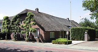
Hoevelaken is a town in the Dutch province of Gelderland. It is a part of the municipality of Nijkerk, and lies about 5 km east of Amersfoort.

European route E73 forms part of the United Nations International E-road network, connecting Hungary and eastern Croatia to Bosnia and Herzegovina and the Adriatic Sea in the vicinity of the port of Ploče. This 679-kilometre (422 mi) route is also designated as the Pan-European Corridor Vc, a branch of the fifth Pan-European corridor. The route largely consists of two-lane roads with at-grade intersections, although in the 2000s, about a third of the route was upgraded to motorway standards. The remainder of the route is currently being upgraded in all the countries spanned. The longest part of this corridor goes through Bosnia and Herzegovina and is widely touted as a road instrumental to the development of the country. As such, and given its geographical location, the road has occasionally been dubbed as the kičma Bosne. The road also serves as the shortest connection of the eastern and southern parts of Croatia.

The A4 motorway, also called Rijksweg 4, is a motorway in the Netherlands running southwards from Amsterdam to the Belgian border near Zandvliet, north of the city of Antwerp. The 119-kilometre-long (74 mi) A4 is divided into two sections; the first and longer section runs from Amsterdam to the A15 near the city of Rotterdam, while the second section starts near Heijningen, where the A29 and the A4 meet, going to the Belgian border.

The A28 motorway is a motorway in the Netherlands. It is approximately 188 kilometers in length.

The A2 motorway is a motorway in the Netherlands. It is one of the busiest highways in the Netherlands. The road connects the city of Amsterdam, near the Amstel interchange with the Belgian border, near Maastricht (NL) and Liège (B), and the Belgian A25 road.

The A12 motorway is a motorway in the Netherlands. The road connects the city of The Hague with the German border, near Zevenaar, and the German Autobahn BAB 3. On its way, it crosses three Dutch provinces: South Holland, Utrecht, and Gelderland.
The Dutch A15 motorway is a set of two motorways in the Netherlands, the A15 and the A18.

The A16 motorway is a motorway in the Netherlands. It runs from the interchange Terbregseplein in the northeastern part of Rotterdam, towards the Belgian border near Hazeldonk. The motorway has 19 exits including 7 interchanges.

The A20 motorway is a motorway in the Netherlands. It is approximately 39 kilometers in length.

The A27 motorway is a motorway in the Netherlands. It is approximately 109 kilometers in length.
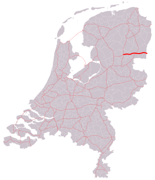
The A37 motorway is a motorway in the Netherlands. It is approximately 42 kilometers in length. The A37 is located entirely in the Dutch province of Drenthe.

The A76 motorway is a motorway in the Netherlands. It is located entirely in the Dutch province of Limburg.
European route E 71 is a north-south Class-A intermediate European road route. It begins in Košice, Slovakia, passes through Budapest in Hungary, Zagreb in Croatia, and ends at Split in Croatia on the Adriatic Sea coast. The total length of the route is 1,016 km (631 mi). The E71 mostly consists of motorways, but considerable sections are either expressways or two-lane roads with at-grade intersections. Nearly all motorway sections of the E71 are tolled, using various toll collection systems including Electronic toll collection (ETC) and ticket systems. Individual segments of the E71 route are shared with several other European routes. The E71 section between Karlovac and Split is inconsistently physically signposted or marked on maps and route planning software. The E71 route has gradually been upgraded from a regular two-lane road to motorway standards since the 1970s; upgrades are still being carried out in some areas.

The E 231 is a European B class road in the Netherlands, connecting the cities of Amsterdam and Amersfoort.

The E 232 is a European B class road in the Netherlands, connecting the cities of Amersfoort and Groningen.

European route E 233 is a west—east European Class-B road part of the International E-road network, running from Hoogeveen in the Netherlands to Cloppenburg in Germany, passing by the Dutch city of Emmen and the German city of Meppen. The road runs concurrently with four other roads over its course, first with the Dutch A37 from its western terminus to the German border, then with the German B402 up to Haselünne, from there on it follows B213 up to northern Cloppenburg, and on the last 2 kilometres (1.2 mi) of the B213 concurrency it also runs concurrent with B72, which it then follows up to its eastern terminus at the A1, which is also part of E 37. The road has a total length of 132 kilometres (82 mi), of which 41 kilometres (25 mi) in the Netherlands and 91 kilometres (57 mi) in Germany.
European route E 35 (E 35) is a north–south European route, running from Amsterdam in the Netherlands to Rome in Italy. In the Netherlands, the highway runs from its northern terminus in Amsterdam eastwards through Utrecht and Arnhem to the German border, near Zevenaar. The road runs concurrently with three other motorways over its entire length, starting on Rijksweg 10 (A10) around Amsterdam, then A2 from southern Amsterdam up to Utrecht, and the last part on A12 until it reaches the German border in the east.


