The National Roads and Motorways in Greece constitute the main road network of the country. These two types of roads are distinct in terms of their construction specifications. Their main difference is that motorways adhere to higher quality construction standards than National Roads.
The Randstad is a roughly crescent- or arc-shaped conurbation in the Netherlands, that includes almost half the country's population. With a central-western location, it connects and comprises the Netherlands' four biggest cities, their suburbs, and many towns in between, that all grew and merged into each other. Among other things, it includes the Port of Rotterdam, the Port of Amsterdam, and Amsterdam Airport Schiphol. With a population of approximately 8.4 million people it is one of the largest metropolitan regions in Europe,[b] comparable in population size to the Rhine-Ruhr metropolitan region or the San Francisco Bay Area, and covers an area of approximately 11,372 km2 (4,391 sq mi).[a] The Randstad had a gross regional domestic product of €510 billion in 2022, making it the second most productive region in the European Union, only behind the Paris metropolitan area. It encompasses both the Amsterdam metropolitan area and Rotterdam–The Hague metropolitan area. It is part of the larger Blue Banana megalopolis.

Bundesautobahn 7 is the longest German Autobahn and the longest national motorway in Europe at 963 km. It bisects the country almost evenly between east and west. In the north, it starts at the border with Denmark as an extension of the Danish part of E45. In the south, the autobahn ends at the Austrian border. This final gap was closed in September 2009.

A controlled-access highway is a type of highway that has been designed for high-speed vehicular traffic, with all traffic flow—ingress and egress—regulated. Common English terms are freeway, motorway, and expressway. Other similar terms include throughway or thruway and parkway. Some of these may be limited-access highways, although this term can also refer to a class of highways with somewhat less isolation from other traffic.

The Adriatic Highway is a road that stretches along the eastern coast of the Adriatic Sea and is part of the European route E65. The road passes through Croatia, with smaller stretches through Bosnia and Herzegovina and Montenegro and ends at the Montenegro-Albania border. It is an undivided two-lane road for almost its entire length, with the exception of a short stretch through Zadar and a 24 kilometres (15 mi) dual-carriageway section from Plano (Trogir) to the southeast suburbs of Split. It was planned in the 1930s and built in the 50s and 60s. The dual carriageway is planned to be extended further southeast to Omiš. Completion of the Adriatic Ionian motorway is proposed in order to replace Adriatic Highway as a high-performance road transport route along the Adriatic coast.

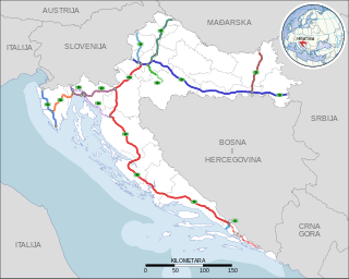
The A1 motorway is the longest motorway in Croatia, spanning 476.3 kilometers (296.0 mi). As it connects the nation's capital Zagreb, in the north of the country, to the second largest city Split on the shore of the Adriatic Sea, the motorway represents a major north–south transportation corridor in Croatia and a significant part of the Adriatic–Ionian motorway. Apart from Zagreb and Split, the A1 motorway runs near a number of major Croatian cities, provides access to several national parks or nature parks, world heritage sites, and numerous resorts, especially along the Adriatic Coast. National significance of the motorway is reflected through its positive economic impact on the cities and towns it connects as well as its importance to tourism in Croatia.

The A6 motorway is a motorway in Croatia spanning 80.2 kilometres (49.8 mi). It connects the nation's capital, Zagreb, via the A1, to the seaport of Rijeka. The motorway forms a major north–south transportation corridor in Croatia and is a part of European route E65 Nagykanizsa–Zagreb–Rijeka–Zadar–Split–Dubrovnik–Podgorica. The A6 motorway route also follows Pan-European corridor Vb.

The A7 motorway is a 42.4-kilometre-long (26.3 mi) motorway in Croatia. It connects the nation's largest port in Rijeka, to the Croatian motorway network, as well as to the Rupa and Pasjak border crossings to Slovenia. The motorway forms part of a longitudinal transportation corridor in Croatia, and it is a part of European route E61 Villach–Ljubljana–Trieste–Rijeka. The A7 motorway route south of Orehovica interchange, where it also intersects Pan-European corridor Vb, is a part of European route E65.

The A28 motorway is a motorway in the Netherlands. It is approximately 188 kilometers in length.

Highways in Croatia are the main transport network in Croatia. The Croatian classification includes several classes of highways:

The D8 state road is the Croatian section of the Adriatic Highway, running from the Slovenian border at Pasjak via Rijeka, Senj, Zadar, Šibenik, Split, Opuzen, and Dubrovnik to the border with Montenegro at Karasovići. Most of the D8 state road remains single carriageway, though with some dual carriageway stretches. The total length of the road through Croatia is 643.1 kilometres (399.6 mi).

The A27 motorway is a motorway in the Netherlands. It is approximately 109 kilometers in length.

Motorways in Serbia are called auto-put, a name which simply means car-road. Roads that are motorways are categorized as state roads of IA category and are marked with one or two digit numbers. Motorways in Serbia have three lanes in each direction, signs are white-on-green, and the normal speed limit is 130 km/h (81 mph). They are maintained and operated by the national road operator company JP "Putevi Srbije".

Adriatic–Ionian motorway or the Blue Corridor, is a future motorway that will stretch along the entire eastern shore of the Adriatic and Ionian seas, spanning the western coast of the Balkan Peninsula from Italy in the north through Slovenia, Croatia, Montenegro, Albania to Greece in the south.

D501 is a state road connecting D3 state road and the A6 motorway Oštrovica interchange to littoral area between Kraljevica, Crikvenica and Novi Vinodolski as well as the island of Krk, terminating at D8 intersection near Jadranovo. The road is 20.3 km long.

The Orehovica interchange is a trumpet interchange in Rijeka, Croatia. The interchange represents the southern terminus of the A6 motorway and it connects the A6 route to the A7 motorway between Škurinje and Draga exits, also representing a part of Rijeka bypass. The interchange is a part of Pan-European corridor Vb. It also represents a junction of European routes E61 and E65.

European route E 22 (E 22) is a west–east European route, running from Holyhead in the United Kingdom, through the Netherlands, Germany, Sweden and Latvia, to Ishim in Russia.

European route E 35 (E 35) is a north–south European route, running from Amsterdam in the Netherlands to Rome in Italy. In the Netherlands, the highway runs from its northern terminus in Amsterdam eastwards through Utrecht and Arnhem to the German border, near Zevenaar. The road runs concurrently with three other motorways over its entire length, starting on Rijksweg 10 (A10) around Amsterdam, then A2 from southern Amsterdam up to Utrecht, and the last part on A12 until it reaches the German border in the east.


