The Randstad is a roughly crescent- or arc-shaped conurbation in the Netherlands, that includes almost half the country's population. With a central-western location, it connects and comprises the Netherlands' four biggest cities, their suburbs, and many towns in between, that all grew and merged into each other. Among other things, it includes the Port of Rotterdam, the Port of Amsterdam, and Amsterdam Airport Schiphol. With a population of approximately 8.4 million people it is one of the largest metropolitan regions in Europe,[b] comparable in population size to the Rhine-Ruhr metropolitan region or the San Francisco Bay Area, and covers an area of approximately 11,372 km2 (4,391 sq mi).[a] The Randstad had a gross regional domestic product of €510 billion in 2022, making it the second most productive region in the European Union, only behind the Paris metropolitan area. It encompasses both the Amsterdam metropolitan area and Rotterdam–The Hague metropolitan area. It is part of the larger Blue Banana megalopolis.
European route E30 is an A-Class European route from the port of Cork in Ireland in the west to the Russian city of Omsk, near the border with Kazakhstan in the east. For much of the Russian stretch, it follows the Trans-Siberian Highway and, east of the Ural Mountains, with AH6 of the Asian Highway Network, which continues to Busan, South Korea. The total length is 6,530 km (4,060 mi)—3,300 km (2,100 mi) from Cork to Moscow, and 3,230 km (2,010 mi) from Moscow to Omsk. The naming is by the United Nations Economic Commission for Europe (UNECE).

A controlled-access highway is a type of highway that has been designed for high-speed vehicular traffic, with all traffic flow—ingress and egress—regulated. Common English terms are freeway, motorway, and expressway. Other similar terms include throughway or thruway and parkway. Some of these may be limited-access highways, although this term can also refer to a class of highways with somewhat less isolation from other traffic.

Leidsche Rijn is a new construction site and neighborhood in Utrecht, the capital of the Dutch province of Utrecht. The area is located west of the Amsterdam–Rhine Canal and its name is derived from the Leidse Rijn canal, which runs through it. At the time of its inception in the 1990s and in the decades that followed, Leidsche Rijn was the largest Vinex location in the Netherlands. Most of this location was on the territory of the former municipality of Vleuten-De Meern, located west of the city of Utrecht. A smaller part of this location, namely the area of Hoge and Lage Weide, was located in the municipality of Utrecht.

Bundesautobahn 9 is an autobahn in Germany, connecting Berlin and Munich via Leipzig and Nuremberg. It is the fifth longest autobahn spanning 529 km (328.71 mi).
Bundesautobahn 30 is a highway in northwestern Germany. It runs from west to east, starting at the Dutch border. On the border it connects with the Dutch A1 motorway, hence, the A 30 is part of the important European connection Berlin – Amsterdam. It is an important connection from Hannover and Minden to Osnabrück, Münster and the Netherlands, and part of European Route E 30.

The A4 motorway, also called Rijksweg 4, is a motorway in the Netherlands running southwards from Amsterdam to the Belgian border near Zandvliet, north of the city of Antwerp. The 119-kilometre-long (74 mi) A4 is divided into two sections; the first and longer section runs from Amsterdam to the A15 near the city of Rotterdam, while the second section starts near Heijningen, where the A29 and the A4 meet, going to the Belgian border.

The A28 motorway is a motorway in the Netherlands. It is approximately 188 kilometers in length.

The A2 motorway is a motorway in the Netherlands. It is one of the busiest highways in the Netherlands. The road connects the city of Amsterdam, near the Amstel interchange with the Belgian border, near Maastricht (NL) and Liège (B), and the Belgian A25 road.
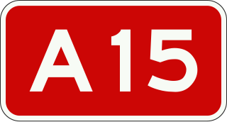
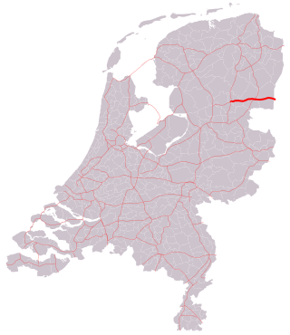
The Dutch A15 motorway is a set of two motorways in the Netherlands, the A15 and the A18.

The A16 motorway is a motorway in the Netherlands. It runs from the interchange Terbregseplein in the northeastern part of Rotterdam, towards the Belgian border near Hazeldonk. The motorway has 19 exits including 7 interchanges.
The A37 motorway is a motorway in the Netherlands. It is approximately 42 kilometers in length. The A37 is located entirely in the Dutch province of Drenthe.

The A12 is an incomplete motorway in Belgium. The road starts at the Dutch border near Zandvliet and goes to Antwerp. There the A12 goes onto the Antwerp ring road R1. Then the road goes via Wilrijk in the direction of Brussels. From here on, it has frontage roads on both sides. Between Wilrijk and Schelle, the A12 is an expressway with major at-grade intersections that contain also the frontage roads. There, from Schelle, it is again a motorway. Then, in Boom, a tunnel leads the A12 under the Rupel river, where the frontage roads take a bridge and then fuse with the motorway itself. Between Breendonk and Sint-Brixius-Rode, there are again at-grade intersections, and then it is again a motorway, until Brussels, where it ends onto the Brussels Ring.

D2 state road is a trunk state road in the northern areas of Croatia that spans from the border crossing with Slovenia at Dubrava Križovljanska in the west via Varaždin, Koprivnica, Virovitica, Našice, Osijek, Vukovar, ending at the Ilok–Bačka Palanka Bridge border crossing with Serbia. The road is 347.9 km (216.2 mi) long.

European route E 233 is a west—east European Class-B road part of the International E-road network, running from Hoogeveen in the Netherlands to Cloppenburg in Germany, passing by the Dutch city of Emmen and the German city of Meppen. The road runs concurrently with four other roads over its course, first with the Dutch A37 from its western terminus to the German border, then with the German B402 up to Haselünne, from there on it follows B213 up to northern Cloppenburg, and on the last 2 kilometres (1.2 mi) of the B213 concurrency it also runs concurrent with B72, which it then follows up to its eastern terminus at the A1, which is also part of E 37. The road has a total length of 132 kilometres (82 mi), of which 41 kilometres (25 mi) in the Netherlands and 91 kilometres (57 mi) in Germany.

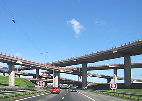
With 139,000 km of public roads, the Netherlands has one of the most dense road networks in the world – much denser than Germany and France, but still not as dense as Belgium. In 2013, 5,191 km were national roads, 7,778 km were provincial roads, and 125,230 km were municipality and other roads. Dutch roads include 3,530 km of motorways and expressways, and with a motorway density of 64 kilometres per 1,000 km2, the country also has one of the densest motorway networks in the world. In Dutch a motorway is called "autosnelweg" or simply "snelweg"; other expressways are just called "autoweg". According to a 2004 estimate, some 12,500 km of road remain as yet unpaved.

The Netherlands has a public road network totaling 139,000 km, one of the densest in the world. Its use has increased since the 1950s and now exceeds 200 billion km traveled per year, three quarters of which is by car, making it among the most intensely used road networks. In 2019, the World Economic Forum ranked the quality of Dutch road infrastructure as the best in Europe and second to Singapore out of 141 countries.
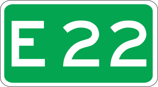
European route E 22 (E 22) is a west–east European route, running from Holyhead in the United Kingdom, through the Netherlands, Germany, Sweden and Latvia, to Ishim in Russia.
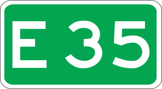
European route E 35 (E 35) is a north–south European route, running from Amsterdam in the Netherlands to Rome in Italy. In the Netherlands, the highway runs from its northern terminus in Amsterdam eastwards through Utrecht and Arnhem to the German border, near Zevenaar. The road runs concurrently with three other motorways over its entire length, starting on Rijksweg 10 (A10) around Amsterdam, then A2 from southern Amsterdam up to Utrecht, and the last part on A12 until it reaches the German border in the east.
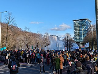
The A12 blockade is a string of protests by Extinction Rebellion (XR) on the Utrechtsebaan in The Hague, irregularly since 6 July 2022 and there were daily blockades from 9 September 2023 until 5 October. The blockades has been stopped until at least Christmas after a motion in the Tweede Kamer passed that called on the government to make a plan to phase out fossil subsidies. The activists demand that the government end fossil fuel subsidies, which are estimated at between €39.7 and €46.4 billion a year. Thousands of activists have been arrested. Political and social reactions to the blockades have been mixed.