M-103 is a state trunkline highway entirely within St. Joseph County in the southwestern region of the U.S. state of Michigan. The trunkline runs between U.S. Highway 12 (US 12) in Mottville and the Indiana state line along undivided highway near the St. Joseph River. With the connection to State Road 15 (SR 15), it provides access to the Indiana Toll Road. The current highway is the second to carry the number; the first version of M-103 has been incorporated into the routing of US 131.

State Road 994, locally known as Quail Roost Drive, is an 8.06-mile-long (12.97 km) east–west four-lane road in southern Miami-Dade County, Florida area. It connects Krome Avenue with U.S. Route 1.

Maryland Route 45 is a state highway in the U.S. state of Maryland. Known for most of its length as York Road, the state highway runs 30.06 miles (48.38 km) from U.S. Route 1 and US 40 Truck in Baltimore north to the Pennsylvania state line in Maryland Line, where the highway continues as State Route 3001. MD 45 is the primary highway between Downtown Baltimore and Towson, the county seat of Baltimore County. North of Interstate 695 (I-695), the state highway parallels I-83 and serves the suburban communities of Lutherville, Timonium, Cockeysville, and Hunt Valley. MD 45 also connects the northern Baltimore County communities of Hereford and Parkton. The state highway is maintained by the Maryland State Highway Administration in Baltimore County and by the Baltimore City Department of Transportation in the city, where the highway also follows Greenmount Avenue.

State Route 111 (SR 111), also known as the Carl Broggi Highway, is a 14-mile-long (23 km) state highway in southern Maine. It runs east–west, connecting the towns of Alfred and Biddeford. It is a major east-west corridor in central York County, Maine.
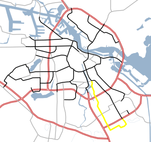
Route 112 is a numbered state highway running 8.5 miles (13.7 km) in the U.S. state of Rhode Island. It connects U.S. Route 1 (US 1) in the town center of Charlestown and Route 138 in the town of Richmond.

State Road 112 (SR 112) is a 9.9-mile-long (15.9 km) east–west state highway connecting Miami International Airport in Miami to Miami Beach in the U.S. state of Florida. Between the airport and Interstate 95, it is locally known as the Airport Expressway, and is an all-electronic toll road between State Road 9 to I-95. Between I-95 and Alton Road (SR 907A) in Miami Beach, SR 112 is signed only as Interstate 195 as it crosses Biscayne Bay by way of the Julia Tuttle Causeway. Between I-195 and its eastern terminus at Collins Avenue (SR A1A), the SR 112 signs are present but infrequent, and the road is locally maintained as Arthur Godfrey Road.

State Road 989, locally known as Allapattah Road and Southwest 112th Avenue, is a 3.0-mile-long (4.8 km) north–south four lane undivided highway in southern Miami-Dade County, Florida, United States, that connects Homestead Air Reserve Base and Cutler Bay. SR 989 begins at an interchange with the Homestead Extension of Florida's Turnpike and ends at an intersection with the Dixie Highway.

State Road 990 is the 2.97-mile-long (4.78 km) central section of the approximately 11.6-mile-long (18.7 km) Killian Drive, also known as Killian Parkway, Southwest 104th Street and Southwest 112th Street and historically South Kendall Drive, located in southern Miami-Dade County, Florida. Running from east to west, it serves to connect the community of The Hammocks with the village of Pinecrest via the community of Kendall, with State Road 990 connecting Southwest 107th Avenue and the Don Shula Expressway to the South Dixie Highway. Recognising the role the road played in southern Miami-Dade County's history and development, the section of State Road 990 between the Expressway and US 1 was designated the Killian Drive State Historic Highway by the Florida Senate in 1995.

New York State Route 111 (NY 111) is a state highway located in Suffolk County, New York, in the United States. It runs north–south for 9.42 miles (15.16 km) through the towns of Islip and Smithtown, connecting NY 27A in the town seat of Islip to the east end of the NY 25 and NY 25A concurrency in Smithtown's Village of the Branch. Most of the road is a two-lane highway, save for several short four-lane stretches in the vicinity of interchanges along the route. NY 111 was assigned as part of the 1930 renumbering of state highways in New York as an East Islip–Village of the Branch highway, using what is now County Route 17 (CR 17) south of Hauppauge. It was realigned to serve the hamlet of Islip in 1966.

New York State Route 309 (NY 309) is a 6.56-mile-long (10.56 km) state highway located entirely in Fulton County, New York, in the United States. The southern terminus of the route is at an intersection with NY 29A in Gloversville. The northern terminus of the route is at a junction with Lily Lake Road in the hamlet of Bleecker, where the highway continues north and west as County Route 112 (CR 112) to London Bridge Road at West Caroga Lake in the town of Caroga. Part of NY 309 and all of CR 112 is located within Adirondack Park. NY 309 was assigned to its current alignment as part of the 1930 renumbering of state highways in New York.
Wyoming Highway 24 (WYO 24), also known as the Bear Lodge Highway, is a 46.72-mile (75.19 km) state highway in Crook County, Wyoming, United States. that connects U.S. Route 14 (US 14) in Carlile Junction with South Dakota Highway 34 (SD 34) at the South Dakota state line. The route passes through the northern portion of the Bear Lodge Mountains, part of the Black Hills National Forest. The highway also passes by Devils Tower National Monument.

State Route 37 (SR 37) is a 153.6-mile-long (247.2 km) state highway that travels west-to-east through portions of Clay, Calhoun, Baker, Mitchell, Colquitt, Cook, Berrien, Lanier, and Clinch counties in the southwestern and south-central parts of the U.S. state of Georgia. The highway connects the Alabama state line west of Fort Gaines to the Homerville area, via Newton, Camilla, Moultrie, Adel, and Lakeland. The highway actually serves as the eastern terminus of a long multi-state route that starts in Mississippi and goes through Alabama.

Puerto Rico Highway 111 (PR-111) is a highway connecting Aguadilla, Puerto Rico at Puerto Rico Highway 2 and Puerto Rico Highway 115 to Utuado, Puerto Rico at Puerto Rico Highway 140.
Puerto Rico Highway 156 (PR-156) is a long east–west highway which connects Caguas to Orocovis and is the main artery to Aguas Buenas since the highway from Puerto Rico Highway 52 to the main downtown has at least two lanes and a shoulder per direction. From Aguas Buenas to Orocovis it is a rural, yet safe road which enters all the business districts and plazas of Aguas Buenas, Comerío, Barranquitas and Orocovis. It is one of two long east–west highways through the center of the island but it never approaches a coast. Puerto Rico Highway 111 approaches Aguadilla's shore near PR-2 but PR-156, ending in Caguas, is nearly 35 kilometers away from the east coast.
National Route 112 is a national highway of Japan that traverses the prefecture of Yamagata in a southeast–northwest routing. It connects the prefecture's capital city, Yamagata in eastern Yamagata Prefecture to the city of Sakata on the prefecture's western coast. It has a total length of 139.2 kilometers (86.5 mi).

State Route 112 (SR 112) is part of Maine's system of numbered state highways, running from SR 9 in Saco to SR 114 in Gorham. The 26-mile-long (42 km) route runs in a C-shape and is signed as north–south.

State Route 111 (SR 111) is a north–south highway in Middle and East Tennessee. The road begins in Soddy-Daisy and ends north of Byrdstown in the community of Static, at the Tennessee/Kentucky state line. The length is 116 mi (186.7 km).
State Route 93 (SR 93) is a state highway in southwest part of the U.S. state of Georgia. The highway runs 60.9 miles (98.0 km) from Moncrief north to Pelham, northeast to Hinsonton, north to Lester, and west to Baconton.

At least 13 special routes of U.S. Route 11 and at least one of U.S. Route 11E have existed.