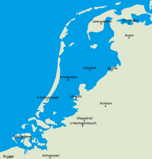
Flevoland is the twelfth and last province of the Netherlands, established on 1 January 1986, when the southern and eastern Flevopolders were merged into one provincial entity. It is located in the centre of the country, where the former Zuiderzee was. Almost all of the land belonging to Flevoland was reclaimed only in the 1950s and 1960s. The province has about 407,905 inhabitants (2016) and consists of 6 municipalities. Its capital is Lelystad and most populous city Almere.

The Zuiderzee was a shallow bay of the North Sea in the northwest of the Netherlands, extending about 100 km inland and at most 50 km wide, with an overall depth of about 4 to 5 metres (13–16 feet) and a coastline of about 300 km. It covered 5,000 km2 (1,900 sq mi). Its name means "southern sea" in Dutch, indicating that the name originates in Friesland, to the north of the Zuiderzee. In the 20th century the majority of the Zuiderzee was closed off from the North Sea by the construction of the Afsluitdijk, leaving the mouth of the inlet to become part of the Wadden Sea. The salt water inlet changed into a fresh water lake now called the IJsselmeer after the river that drains into it, and by means of drainage and polders, an area of some 1,500 km2 (580 sq mi) was reclaimed as land. This land eventually became the province of Flevoland, with a population of nearly 400,000 (2011).

The Zuiderzee Works is a man-made system of dams and dikes, land reclamation and water drainage work, in total the largest hydraulic engineering project undertaken by the Netherlands during the twentieth century. The project involved the damming of the Zuiderzee, a large, shallow inlet of the North Sea, and the reclamation of land in the newly enclosed water using polders. Its main purposes are to improve flood protection and create additional land for agriculture.

The Delta Works is a series of construction projects in the southwest of the Netherlands to protect a large area of land around the Rhine-Meuse-Scheldt delta from the sea. The works consist of dams, sluices, locks, dykes, levees, and storm surge barriers located in the provinces of South Holland and Zeeland.
The Afsluitdijk is a major dam and causeway in the Netherlands. It was constructed between 1927 and 1932 and runs from Den Oever in North Holland province to the village of Zurich in Friesland province, over a length of 32 kilometres (20 mi) and a width of 90 metres (300 ft), at an initial height of 7.25 metres (23.8 ft) above sea level.
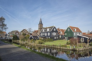
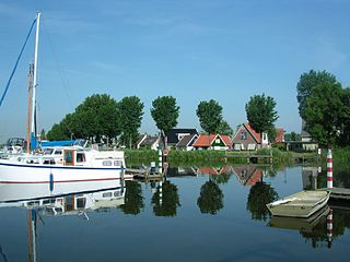
Marken is a village in the municipality of Waterland in the province of North Holland, Netherlands. It had a population of 1,810 as of 2012 and is located in forms a peninsula in the Markermeer and was formerly an island in the Zuiderzee. The characteristic wooden houses of Marken are a tourist attraction.

The Frisian Islands, also known as the Wadden Islands or the Wadden Sea Islands, form an archipelago at the eastern edge of the North Sea in northwestern Europe, stretching from the northwest of the Netherlands through Germany to the west of Denmark. The islands shield the mudflat region of the Wadden Sea from the North Sea.

Spaarndam is a small village in the province of North Holland, the Netherlands, on the Spaarne river and the IJ lake. The oldest part of the village, on the western side of the Spaarne, belongs to the municipality of Haarlem; the newer part on the eastern side is a part of the municipality of Haarlemmermeer. The village is built around a dam in the river, which is also the division line of the two municipalities.
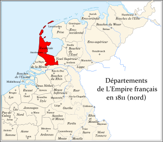
Zuyderzée was a department of the First French Empire in the present-day Netherlands. It is named after the Zuiderzee sea inlet. It was formed in 1810, when the Kingdom of Holland was annexed by France. Its territory corresponded more or less with the present-day Dutch provinces of North Holland and Utrecht. Its capital was Amsterdam.
The Markerwaard is the name of a proposed polder in the IJsselmeer that was never built. The construction of Markerwaard would have resulted in the near-total reclamation of the Markermeer.
Rhoon is a village that borders the municipality of the city of Rotterdam, South Holland, the Netherlands.

The Zuiderzee Museum, located on Wierdijk in the historic center of Enkhuizen, is a Dutch museum devoted to preserving the cultural heritage and maritime history from the old Zuiderzee region. With the closing of the Afsluitdijk on May 28, 1932, the Zuiderzee was split in two parts: the waters below the Afsluitdijk are now called the IJsselmeer, while the waters north of it are called the Waddenzee.
Flood control is an important issue for the Netherlands, as due to its low elevation, approximately two thirds of its area is vulnerable to flooding, while the country is densely populated. Natural sand dunes and constructed dikes, dams, and floodgates provide defense against storm surges from the sea. River dikes prevent flooding from water flowing into the country by the major rivers Rhine and Meuse, while a complicated system of drainage ditches, canals, and pumping stations keep the low-lying parts dry for habitation and agriculture. Water control boards are the independent local government bodies responsible for maintaining this system.

Zeeburg is a former borough of Amsterdam. It had 52,701 residents and an area of 19.31 km². The construction of new islands to the east called IJburg made it the most rapidly growing borough of Amsterdam. On 1 May 2010 Zeeburg merged with the borough of Amsterdam-Oost.

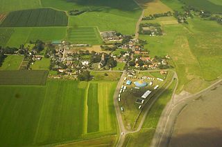
Breezanddijk is a small community that lies near the midpoint of the Afsluitdijk, part of the A7 motorway, in the Netherlands. It is located on a former artificial island which was created during the construction of the dam, and it belongs to the municipality of Súdwest-Fryslân, in Friesland province. The hamlet lies between Den Oever and Kornwerderzand.

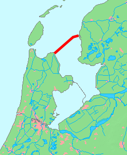
The Houtribdijk is a dam in the Netherlands, built between 1963 and 1975 as part of the Zuiderzee Works, which connects the cities of Lelystad and Enkhuizen. On the west side of the dike is the Markermeer and on the east is the IJsselmeer. The 27-kilometer-long dike was intended for the Markerwaard, but this polder is now unlikely to be constructed.

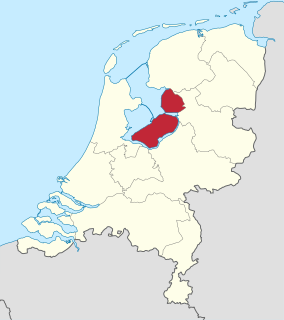
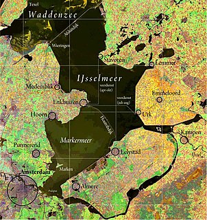
The Markermeer is a 700 km2 (270 sq mi) lake in the central Netherlands in between North Holland, Flevoland and its larger sibling, the IJsselmeer. A shallow lake at some 3 to 5 m in depth, it is named after the small former island, now peninsula, of Marken that lies within it. The southwest side of the lake that begins where the IJ once emptied into the Zuiderzee is known as the IJmeer.