Markerwaard

Last updated
The Markerwaard would be on what is now the Markermeer IJsselmeer satellite.jpg
The Markerwaard would be on what is now the Markermeer

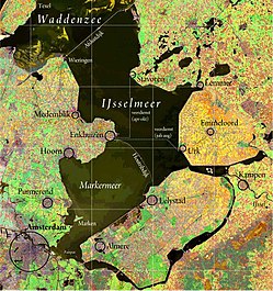
The Markerwaard is the name of a proposed, but never built, polder adjoining the IJsselmeer in the central Netherlands. Its construction would have resulted in the near-total reclamation of the Markermeer.

Cornelis Lely's plan projected a polder in the south-west of the Zuiderzee, originally named Hoornsche Polder, referring to Hoorn, then simply "Southwest Polder". [1] Later the name was changed to Markerwaard Polder, after the island of Marken. However, reclamation of three other polders took place first, and preparations for the Markerwaard were being made while draining of the northeast and southeast polders (today's Flevoland) were underway.

In 1941 work for this project started; about 2 km (1¼ miles) of a dike north of Marken was built. It would have had an area of nearly 600 km2 (200 sq. mi.). But the German occupation stopped the project. Later, it was decided that the Flevopolder should have priority. In 1957, the island of Marken was connected to mainland Holland. In 1976 the dam Houtribdijk connecting Enkhuizen and Lelystad was completed, a necessary step in the construction of Markerwaard, the dikes for the bordering lakes were still to be completed. However the entire project became mired in political and environmental controversy. In the late 1970s, the project was revised down leaving wide bordering lakes between the polder and North Holland. Marken would remain a peninsula, unlike on the original project. At this stage, the Markerwaard would have had an area of 410 km2 (160 sq. mi.).

As of 1961 Markerwaard was expected to be finished in 1978. [2] The debate on a final decision regarding it took over twenty years. The questions concerned the need, on one side, for more agricultural areas, new residential subdivisions, and a new airport (to relieve pressure on Schiphol). On the other side of the debate were primarily ecological issues, with the argument that the value of the lake as a recreation area was considered by some to be stronger than the potential benefits of the polder. Additionally, it was argued that, in case of drought, the lake would be very useful for the production of drinking water, and that in heavy weather, the lake serves as a buffer zone.

Finally, in 2003, it was decided not to build this polder. [3] However discussions never completely closed. [4]

In 2012, plans emerged to create the Marker Wadden, [5] a group of islands designed to establish nature reserves in the north of the Markermeer. In contrast to the Markerwaard, no human occupation is planned. The creation process began in early 2016. [6]

Related Research Articles

<span class="mw-page-title-main">Flevoland</span> Province of the Netherlands

Flevoland is the twelfth and newest province of the Netherlands, established in 1986, when the southern and eastern Flevopolders, together with the Noordoostpolder, were merged into one provincial entity. It is in the centre of the country in the former Zuiderzee, which was turned into the freshwater IJsselmeer by the closure of the Afsluitdijk in 1932. Almost all of the land belonging to Flevoland was reclaimed in the 1950s and 1960s while splitting the Markermeer and Bordering lakes from the IJsselmeer. As to dry land, it is the smallest province of the Netherlands at 1,410 km2 (540 sq mi), but not gross land as that includes much of the waters of the fresh water lakes (meres) mentioned.

<span class="mw-page-title-main">Polder</span> Reclaimed land

A polder is a low-lying tract of land that forms an artificial hydrological entity, enclosed by embankments known as dikes. The three types of polder are:

  1. Land reclaimed from a body of water, such as a lake or the seabed
  2. Flood plains separated from the sea or river by a dike
  3. Marshes separated from the surrounding water by a dike and subsequently drained; these are also known as koogs, especially in Germany
<span class="mw-page-title-main">Lelystad</span> City and municipality in Flevoland, Netherlands

Lelystad is a municipality and a city in the centre of the Netherlands, and it is the capital of the province of Flevoland. The city, built on reclaimed land, was founded in 1967 and was named after Cornelis Lely, who engineered the Afsluitdijk, making the reclamation possible. Lelystad is approximately 3 metres below sea level.

<span class="mw-page-title-main">IJsselmeer</span> Lake in the Netherlands

The IJsselmeer, also known as Lake IJssel in English, is a closed-off inland bay in the central Netherlands bordering the provinces of Flevoland, North Holland and Friesland. It covers an area of 1,100 km2 (420 sq mi) with an average depth of 4.5 m (15 ft). The river IJssel flows into the IJsselmeer.

<span class="mw-page-title-main">Zuiderzee</span> Former inland sea in the Netherlands, now the IJsselmeer

The Zuiderzee or Zuider Zee was a shallow bay of the North Sea in the northwest of the Netherlands, extending about 100 km inland and at most 50 km wide, with an overall depth of about 4 to 5 metres (13–16 feet) and a coastline of about 300 km. It covered 5,000 km2 (1,900 sq mi). Its name is Dutch for "southern sea", indicating that the name originates in Friesland, to the north of the Zuiderzee.

<span class="mw-page-title-main">North Holland</span> Province of the Netherlands

North Holland is a province of the Netherlands in the northwestern part of the country. It is located on the North Sea, north of South Holland and Utrecht, and west of Friesland and Flevoland. As of January 2023, it had a population of about 2,952,000 and a total area of 4,092 km2 (1,580 sq mi), of which 1,429 km2 (552 sq mi) is water.

<span class="mw-page-title-main">Zuiderzee Works</span> Land reclamation in the Netherlands

The Zuiderzee Works is a system of dams and dikes, land reclamation and water drainage work, which was the largest hydraulic engineering project undertaken by the Netherlands during the twentieth century. The project involved the damming of the Zuiderzee, a large, shallow inlet of the North Sea, and the reclamation of land in the newly enclosed water using polders. Its main purposes are to improve flood protection and create additional land for agriculture.

<span class="mw-page-title-main">Urk</span> Municipality in Flevoland, Netherlands

Urk is a municipality and a town in the Flevoland province in the central Netherlands.

<span class="mw-page-title-main">Beemster</span> Former municipality in North Holland, Netherlands

Beemster is a former municipality in the Netherlands, in the province of North Holland. The Beemster is the first so-called polder in the Netherlands that was reclaimed from a lake, the water being extracted from the lake by windmills. The Beemster polder was drained between 1609 and 1612. It has preserved intact its well-ordered landscape of fields, roads, canals, dykes and settlements, laid out in accordance with classical and Renaissance planning principles. A grid of canals parallels the grid of roads in the Beemster. The grids are offset: the larger feeder canals are offset by approximately one kilometer from the larger roads.

<span class="mw-page-title-main">Afsluitdijk</span> Dam

The Afsluitdijk is a major dam and causeway in the Netherlands. It was constructed between 1927 and 1932 and runs from Den Oever in North Holland province to the village of Zurich in Friesland province, over a length of 32 kilometres (20 mi) and a width of 90 metres (300 ft), at an initial height above Amsterdam Ordnance Datum of between 6.7 metres (22 ft) along the section at Friesland, and 7.4 metres (24 ft) where it crosses the deep channel of the Vlieter. The height at the greater sea depths west of Friesland was required to be a minimum of 7 metres everywhere when originally constructed.

<span class="mw-page-title-main">Marken</span> Village in North Holland, Netherlands

Marken is a village in the municipality of Waterland in the province of North Holland, Netherlands. It had a population of 1,745 as of 2021, and occupies a peninsula in the Markermeer. It was, until 1957, an island in the former Zuiderzee. The characteristic wooden houses of Marken are a tourist attraction.

<span class="mw-page-title-main">Cornelis Lely</span> Dutch politician

Cornelis Lely was a Dutch politician of the Liberal Union (LU) and civil engineer. He oversaw the passage of an act of parliament authorising construction of the Zuiderzee Works, a huge project – designed to his own plans – that turned the Zuiderzee into a lake and made possible the conversion of a vast area of former seabed into dry land.

<span class="mw-page-title-main">Flood control in the Netherlands</span> Manmade control of flooding in the Netherlands

Flood control is an important issue for the Netherlands, as due to its low elevation, approximately two thirds of its area is vulnerable to flooding, while the country is densely populated. Natural sand dunes and constructed dikes, dams, and floodgates provide defense against storm surges from the sea. River dikes prevent flooding from water flowing into the country by the major rivers Rhine and Meuse, while a complicated system of drainage ditches, canals, and pumping stations keep the low-lying parts dry for habitation and agriculture. Water control boards are the independent local government bodies responsible for maintaining this system.

<span class="mw-page-title-main">Houtribdijk</span> Dam in the Netherlands

The Houtribdijk is a dam in the Netherlands, built between 1963 and 1975 as part of the Zuiderzee Works, which connects the cities of Lelystad and Enkhuizen. On the west side of the dike is the Markermeer and on the east is the IJsselmeer. The 27-kilometer-long dike was intended for the Markerwaard, but this polder is now unlikely to be constructed.

<span class="mw-page-title-main">Markermeer</span> Lake in the central Netherlands

The Markermeer is a 700 km2 (270 sq mi) lake in the central Netherlands in between North Holland, Flevoland, and its smaller and larger neighbors, the IJmeer and IJsselmeer. A shallow lake at 3 to 5 m in depth, matching the reclaimed land to its west, north-west and east it is named after the small former island, now peninsula, of Marken on its west shore.

<span class="mw-page-title-main">Pilot Polder Andijk</span>

The pilot Polder Andijk, or Test Polder Andijk, Proefpolder Andijk in Dutch, is a polder established in 1926 - 1927 in the Zuiderzee near the village of Andijk. The aim of this prototype is to study the embankments and agriculture for future polders in the Zuiderzee Works. In 1929, the pilot polder was inaugurated by Queen Wilhelmina of the Netherlands.

Amsteldiepdijk is a dike between Van Ewijcksluis and the island of Wieringen. It was built in 1924 and closes a portion of the Amsteldiep and of the Ulkediep.

<span class="mw-page-title-main">Naviduct</span> Naviduct: 2003, Netherlands

A naviduct is a special class of navigable aqueduct, in which the waterway also includes a lock. One example of a naviduct has been built at Enkhuizen on the Houtribdijk in the Netherlands on the instructions of the Rijkswaterstaat. This cost over €55 million and was completed in 2003. It is big enough to simultaneously transfer two large Rhine river-barges from the Markermeer to the IJsselmeer or vice versa. The structure was chosen because a busy waterway crosses a dam carrying a busy road, but the space available for separate aqueduct and lock facilities was restricted.

<span class="mw-page-title-main">Marker Wadden</span> Artificial archipelago in the Netherlands

The Marker Wadden is an artificial archipelago under development in the Markermeer, a lake in the Netherlands. The first island was inaugurated on 24 September 2016. It is a nature reserve alternative to the much bigger proposed Markerwaard polder that was begun in 1941 but paused and finally abandoned in 2003.

<span class="mw-page-title-main">Land reclamation in the Netherlands</span>

Land reclamation in the Netherlands has a long history. As early as in the 14th century, the first reclaimed land had been settled. Much of the modern land reclamation has been done as a part of the Zuiderzee Works since 1919.

References

  1. Ir. J.F.R. van de Wall (1952): 'De groei van het ontwerp voor de Oosterpolder', Ts. v.h. Kon. Ned. Aardr. Gen., 69:3, p.17.
  2. Ley, Willy (October 1961). "The Home-Made Land". For Your Information. Galaxy Science Fiction. pp. 92–106.
  3. In de Nota RuimteRuimte voor ontwikkeling, Deel 4 Definitieve versie, Hoofdstuk 4 Gebieden en thema's, Paragraaf 6 IJsselmeergebied, Sub-paragraaf 4 Specifieke beleidskeuzen, Kop 3 Buitendijkse ontwikkelingen staat op pag. 156: "De ruimtelijke reservering voor een Markerwaard vervalt." PDF Archived 2014-01-14 at the Wayback Machine
  4. Vereniging Vrienden van de Markerwaard (VVM); Studiemiddag Lelystad 2005 "Archived copy". Archived from the original on 2015-09-23. Retrieved 2015-09-23.{{cite web}}: CS1 maint: archived copy as title (link) en Plan Markermeer Plus 2008 . Also see Reformatorisch Dagblad Archived 2015-09-23 at the Wayback Machine .
  5. Intentieverklaring Marker Wadden, Rijkswaterstaat, Dutch government bulletin, April 2013
  6. Boskalis wins Marker Wadden Island contract, Dredging News Online, 15 September 2015
  7. Michelin n°6 _1972
  8. "De Markerwaard als Toren van Babel?".