Darnestown is a United States census-designated place (CDP) and an unincorporated area in Montgomery County, Maryland. The CDP is 17.70 square miles (45.8 km2) with the Potomac River as its southern border and the Muddy Branch as much of its eastern border. Seneca Creek borders portions of its north and west sides. The Travilah, North Potomac, and Germantown census-designated places are adjacent to it, as is the city of Gaithersburg. Land area for the CDP is 16.39 square miles (42.4 km2). The Darnestown CDP has a population of approximately 6,400, while the village of Darnestown is considerably smaller in size and population. Washington, D.C. is about 25 miles (40 km) away.

The Chesapeake and Ohio Canal, abbreviated as the C&O Canal and occasionally called the "Grand Old Ditch," operated from 1831 until 1924 along the Potomac River from Washington, D.C., to Cumberland, Maryland. The canal's principal cargo was coal from the Allegheny Mountains.

The Chesapeake and Ohio Canal National Historical Park is located in the District of Columbia and the state of Maryland. The park was established in 1961 as a National Monument by President Dwight D. Eisenhower to preserve the neglected remains of the Chesapeake and Ohio Canal and many of its original structures. The canal and towpath trail extends along the Potomac River from Georgetown, Washington, D.C., to Cumberland, Maryland, a distance of 184.5 miles (296.9 km). In 2013, the path was designated as the first section of U.S. Bicycle Route 50.

The Patowmack Canal is a series of five inoperative canals located in Maryland and Virginia, United States, that was designed to bypass rapids in the Potomac River upstream of the present Washington, D.C. area. The most well known of them is the Great Falls skirting canal, whose remains are managed by the National Park Service as it is within Great Falls Park Virginia, an integral part of the George Washington Memorial Parkway.

The Ohio and Erie Canal was a canal constructed during the 1820s and early 1830s in Ohio. It connected Akron with the Cuyahoga River near its outlet on Lake Erie in Cleveland, and a few years later, with the Ohio River near Portsmouth. It also had connections to other canal systems in Pennsylvania.

The James River and Kanawha Canal was a partially built canal in Virginia intended to facilitate shipments of passengers and freight by water between the western counties of Virginia and the coast. Ultimately its towpath became the roadbed for a rail line following the same course.
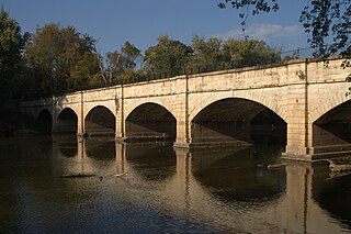
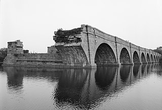
The Monocacy Aqueduct — or C&O Canal Aqueduct No. 2 — is the largest aqueduct on the Chesapeake and Ohio Canal, crossing the Monocacy River just before it empties into the Potomac River in Frederick County, Maryland, USA. The 438 foot aqueduct was built by three separate contractors between 1829 and 1833 at a cost of US$127,900.

The Washington Aqueduct is an aqueduct that provides the public water supply system serving Washington, D.C., and parts of its suburbs. One of the first major aqueduct projects in the United States, the Aqueduct was commissioned by Congress in 1852, and construction began in 1853 under the supervision of Montgomery C. Meigs and the US Army Corps of Engineers. Portions of the Aqueduct went online on January 3, 1859, and the full pipeline began operating in 1864. The system has been in continuous use ever since. It is listed as a National Historic Landmark, and the Union Arch Bridge within the system is listed as a Historic Civil Engineering Landmark.

Seneca Creek is a 5.8-mile-long (9.3 km) stream in Montgomery County, Maryland, USA, roughly 16 miles (26 km) northwest of Washington, D.C. It drains into the Potomac River.
Schoharie Crossing State Historic Site, also known as Erie Canal National Historic Landmark, is a historic district that includes the ruins of the Erie Canal aqueduct over Schoharie Creek, and a 3.5-mile (5.6 km) long part of the Erie Canal, in the towns of Glen and Florida within Montgomery County, New York. It was the first part of the old canal to be designated a National Historic Landmark, prior to the designation of the entire New York State Barge Canal as a NHL in 2017.
The Union Arch Bridge, also called the "Cabin John Bridge", is a historic masonry structure in Cabin John, Maryland. It was designed as part of the Washington Aqueduct. The bridge construction began in 1857 and was completed in 1864. The roadway surface was added later. The bridge was designed by Alfred Landon Rives, and built by the United States Army Corps of Engineers under the direction of Lieutenant Montgomery C. Meigs.
The Old Lock Pump House on the Chesapeake & Delaware Canal was one of the first National Historic Landmarks to recognize an engineering achievement rather than an important building or a place associated with an historic event. The pump house, whose first element was built in 1837, preserves a feature of the old canal, which relied on locks and pumps to move vessels over the low divide of the Delmarva Peninsula between Chesapeake Bay and Delaware Bay. Because there are no large rivers on the peninsula, water had to be pumped uphill to fill the upper canal and locks. When the canal was cut deeper in the twentieth century, such measures were no longer required, and the pump house is one of the last relics of the old canal.
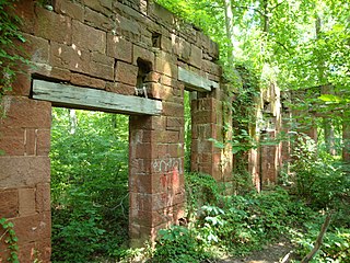
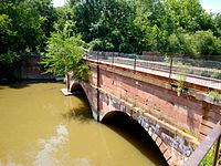
Seneca Quarry is a historic site located at Seneca, Montgomery County, Maryland. It is located along the Chesapeake and Ohio Canal on the north bank of the Potomac River, just west of Seneca Creek. The quarry was the source of stone for two Potomac River canals: the Potowmack Canal on the Virginia side of Great Falls; and the C&O Canal, having supplied red sandstone for the latter for locks 9, 11, 15 - 27, and 30, the accompanying lock houses, and Aqueduct No. 1, better known as Seneca Aqueduct, constructed from 1828 to 1833.

The Seneca Historic District is a national historic district located at Poolesville, Montgomery County, Maryland. The district comprises 3,850 acres (1,560 ha) of federal, state, and county parkland and farmland in which 15 historic buildings are situated. The Chesapeake and Ohio Canal, including Seneca Aqueduct, Lock No. 24, the adjacent lock house; as well as the Seneca Quarry and quarry masters house above the quarry also stand within the district and are also within Seneca Creek State Park. The 15 historic structures are surrounded by dependencies of various periods, in most cases dating from the period of the dwelling. There are slave quarters, smokehouses, springhouses, corn cribs, and tobacco barns.

Seneca is an unincorporated community in Montgomery County, Maryland, United States. It is located near the intersection of River Road and Seneca Creek, not far from the Chesapeake and Ohio Canal and Potomac River. Its history goes back before the American Revolutionary War and it thrived when the canal was operating—having several warehouses, a mill, a store, a school, and a hotel. Fighting occurred in the area on more than one occasion during the American Civil War. The community declined as the C&O Canal declined.

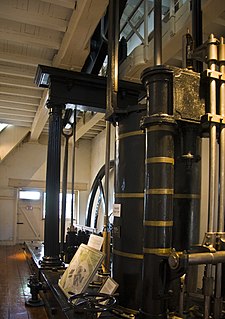
Power Plant and Dam No. 5, also known as Honeywood Dam, comprises a dam on the Potomac River, originally built for the Chesapeake and Ohio Canal, and a power plant built to take advantage of the river's flow to generate hydroelectric power. The dam is included in Chesapeake and Ohio Canal National Historical Park.
The Chesapeake and Ohio Canal (C&O) used 11 navigable aqueducts to carry the canal over rivers and streams that were too wide for a culvert to contain. Aqueducts, like locks and other masonry structures, were called "works of art" by the canal board of directors.

The Pennyfield Lock and lockhouse are part of the 184.5-mile (296.9 km) Chesapeake and Ohio Canal that operated in the United States along the Potomac River from the 1830s through 1923. The lock, located at towpath mile-marker 19.7, is near River Road in Montgomery County, Maryland. The original lock house was built in 1830, and its lock was completed in 1831.

Swains Lock and lock house are part of the 184.5-mile (296.9 km) Chesapeake and Ohio Canal that operated in the United States along the Potomac River from the 1830s through 1923. It is located at towpath mile-marker 16.7 near Potomac, Maryland, and within the Travilah census-designated place in Montgomery County, Maryland. The lock and lock house were built in the early 1830s and began operating shortly thereafter.

Riley's Lock (Lock 24) and lock house are part of the 184.5-mile (296.9 km) Chesapeake and Ohio Canal that operated in the United States along the Potomac River from the 1830s through 1923. They are located at towpath mile-marker 22.7 adjacent to Seneca Creek, in Montgomery County, Maryland. The lock is sometimes identified as Seneca because of the Seneca Aqueduct that carried the canal over the creek to the lift lock. The name Riley comes from John C. Riley, who was lock keeper from 1892 until the canal closed permanently in 1924.