
North Lanarkshire is one of the 32 council areas of Scotland. It borders the north-east of the Glasgow City council area and contains many of Glasgow's suburbs, commuter towns, and villages. It also borders East Dunbartonshire, Falkirk, Stirling, South Lanarkshire, and West Lothian. The council area covers parts of the historic counties of Dunbartonshire, Lanarkshire, and Stirlingshire. The council is based in Motherwell.

The Union Canal, full name the Edinburgh and Glasgow Union Canal, is a canal in Scotland, running from Falkirk to Edinburgh, constructed to bring minerals, especially coal, to the capital. It was opened in 1822 and was initially successful, but the construction of railways, particularly the Edinburgh and Glasgow Railway, which opened in 1842, diminished its value as a transport medium. It fell into slow commercial decline and was closed to commercial traffic in 1933. It was officially closed in 1965. The canal is listed as three individual scheduled monuments by Historic Scotland according to the three former counties, Midlothian, West Lothian and Stirlingshire, through which it flows.

Abronhill is an area in the north-east of Cumbernauld, North Lanarkshire, Scotland. It extends one to two miles from Cumbernauld Town Centre. Abronhill was planned with its own shopping centre and has three primary schools, along with several churches. Abronhill has 41 streets. Abronhill, and particularly the now-demolished Abronhill High School,, were used extensively as the filming location for Bill Forsyth's 1981 film Gregory's Girl and its sequel Gregory's Two Girls.

The River Kelvin is a tributary of the River Clyde in northern and northeastern Glasgow, Scotland. It rises on the moor south east of the village of Banton, east of Kilsyth. At almost 22 miles (35 km) long, it initially flows south to Dullatur Bog where it falls into a man made trench and takes a ninety degree turn flowing west through Strathkelvin and along the northern boundary of the bog parallel with the Forth and Clyde Canal.

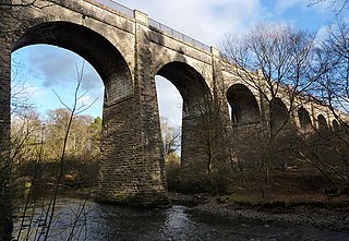
Castlecary is a small historic village in North Lanarkshire, Scotland, directly adjacent to the border with Falkirk. It has long been associated with infrastructure, being adjacent to a bridged river, a Roman fort and roads, a nationwide canal, a Victorian railway viaduct, and a modern motorway. Castlecary is close to the town of Cumbernauld but like Dullatur and Luggiebank is not officially part of the town. Around 1725, the barony of Castlecary, with a population of just seventeen families, was disjoined from the parish of Falkirk, and annexed to Cumbernauld quoad sacra. Castlecary is also near Allandale which, though in the Falkirk council area, was built for Castlecary fireclay workers.

The Forth and Clyde canal pathway runs between the Firth of Forth and the Firth of Clyde and is a 106-kilometre-long (66 mi) footpath and cycleway that runs across Scotland, between Bowling, west of Glasgow, and Lochrin Basin in Edinburgh. The path runs on the towpaths of the Forth & Clyde and Union Canals and is entirely off-road. The path is well maintained and its surface is generally good, although there are some stretches particularly between Falkirk and the outskirts of Edinburgh where wet weather leads to muddy conditions unsuitable for road intended bicycles. It is well used by walkers and cyclists, and designated as one of Scotland's Great Trails by NatureScot. It also forms part of the National Cycle Network, being designated as Route 754. Sustrans advises that the path is best followed from the Clyde to the Forth because the prevailing wind is from the south west. Much of the path is also suitable for experienced horseriders, although in some places low bridges, narrow aqueducts and gates may restrict access for horses.

Upperton is a village in North Lanarkshire, Scotland, near Airdrie and Cumbernauld, about 20 miles (32 km) north-east of Glasgow. It lies close to the B803 between Greengairs and Slamannan. Other nearby roads include Hulks Road towards the A73, Fannyside Road to Abronhill and the road to Caldercruix via Longriggend. The Avon Water flows through the village and meets the Shielhill Burn, a tributary of the River Avon, just outside the village. William Forrest's 1816 map of Lanarkshire shows the site as Upper Town. The Ordnance Survey map sites "Uppertown" on Shiel Hill.

The Carron is a river in central Scotland, rising in the Campsie Fells and flowing along Strathcarron into the Firth of Forth. It has given its name to several locations in Stirlingshire, as well as a type of cannon, a line of bathtubs, two warships, and an island in the Southern Hemisphere.

Slamannan is a village in the south of the Falkirk council area in Central Scotland. It is 4.6 miles (7.4 km) south-west of Falkirk, 6.0 miles (9.7 km) east of Cumbernauld and 7.1 miles (11.4 km) north-east of Airdrie.
The Avon Aqueduct is a navigable aqueduct that carries the Union Canal over the River Avon, near Linlithgow, Scotland.
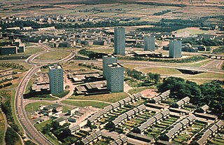
Cumbernauld is a large town in the historic county of Dunbartonshire and council area of North Lanarkshire, Scotland. It is the tenth most-populous locality in Scotland and the most populated town in North Lanarkshire, positioned in the centre of Scotland's Central Belt. Geographically, Cumbernauld sits between east and west, being on the Scottish watershed between the Forth and the Clyde; however, it is culturally more weighted towards Glasgow and the New Town's planners aimed to fill 80% of its houses from Scotland's largest city to reduce housing pressure there.

Longriggend is a village in North Lanarkshire, Scotland, with a population of approximately 200.

The Luggie Water is one of two streams which flow out of Cumbernauld. The Scottish New Town’s name derives from the Gaelic for "the meeting of the waters", which possibly refers to the Luggie Water and the Red Burn, both of which run through Cumbernauld but which never meet.

Cumbernauld Castle was the predecessor of Cumbernauld House in the Park in Cumbernauld. The Motte of the earliest castle survives, and stones of the second castle are incorporated in the present house.

The Red Burn is one of two main streams which flow out of Cumbernauld. The Scottish New Town’s name derives from the Gaelic for "the meeting of the waters" and there is broad agreement that one of these waters is the Red Burn.
The Falkirk Braes is a geographical and sociopolitical entity within the Falkirk local authority area in Scotland. The population is approximately 32,000 (2018), about 20% of the total for Falkirk council area.


