The Forth and Clyde Canal is a canal opened in 1790, crossing central Scotland; it provided a route for the seagoing vessels of the day between the Firth of Forth and the Firth of Clyde at the narrowest part of the Scottish Lowlands. This allowed navigation from Edinburgh on the east coast to the port of Glasgow on the west coast. The canal is 35 miles (56 km) long and it runs from the River Carron at Grangemouth to the River Clyde at Bowling, and had an important basin at Port Dundas in Glasgow.

Falkirk is one of 32 unitary authority council areas of Scotland. It was formed on 1 April 1996 by way of the Local Government etc. (Scotland) Act 1994 from the exact boundaries of Falkirk District, one of three parts of the Central region created in 1975, which was abolished at that time. Prior to the 1975 reorganisation, the majority of the council area was part of the historic county of Stirlingshire, and a small part, namely Bo'ness and Blackness, was part of the former county of West Lothian.

Falkirk is a town in the Central Lowlands of Scotland, historically within the county of Stirlingshire. It lies in the Forth Valley, 23+1⁄2 miles northwest of Edinburgh and 20+1⁄2 miles (33 km) northeast of Glasgow.
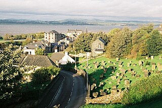
Borrowstounness is a town and former burgh and seaport on the south bank of the Firth of Forth in the Central Lowlands of Scotland. Historically part of the county of West Lothian, it is a place within the Falkirk council area, 17 miles northwest of Edinburgh and 6+3⁄4 miles east of Falkirk. At the 2011 United Kingdom census, the population of the Bo'ness locality was 15,100.
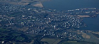
Grangemouth is a town in the Falkirk council area, Scotland. Historically part of the county of Stirlingshire, the town lies in the Forth Valley, on the banks of the Firth of Forth, 3 miles (4.8 km) east of Falkirk, 5 miles (8.0 km) west of Bo'ness and 13 miles (20.9 km) south-east of Stirling. Grangemouth had a resident population of 17,906 according to the 2001 Census. Preliminary figures from the 2011 census reported the number as 17,373.

Stirlingshire or the County of Stirling is a historic county and registration county of Scotland. Its county town is Stirling.

Airth is a Royal Burgh, village, former trading port and civil parish in Falkirk, Scotland. It is 6 miles north of Falkirk town and sits on the banks of the River Forth. Airth lies on the A905 road between Grangemouth and Stirling and is overlooked by Airth Castle; the village retains two market crosses and a small number of historic houses. At the time of the 2001 census the village had a population of 1,273 residents but this has been revised to 1,660 according to a 2008 estimate.
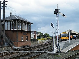
The Bo’ness and Kinneil Railway is a heritage railway in Bo'ness, Scotland. It is operated by the Scottish Railway Preservation Society (SRPS), a registered charity, and operates a total of over 5 miles (8 km) of track, virtually the entire Slamannan and Borrowstounness Railway that became part of the former North British Railway on the Firth of Forth. Bo'ness railway station is the nucleus of the Museum of Scottish Railways.

Larbert is a town in the Falkirk council area of Scotland. The town lies in the Forth Valley above the River Carron which flows from the west. Larbert is three miles from the shoreline of the Firth of Forth and 2+1⁄2 miles northwest of Falkirk. Stenhousemuir lies directly east of Larbert, with both settlements being contiguous and sharing certain public amenities with one another.

Falkirk is a county constituency of the House of Commons of the Parliament of the United Kingdom. It was created for the 2005 general election, replacing Falkirk West and part of Falkirk East.
The Edinburgh and Glasgow Railway was authorised by Act of Parliament on 4 July 1838. It was opened to passenger traffic on 21 February 1842, between its Glasgow Queen Street railway station and Haymarket railway station in Edinburgh. Construction cost £1,200,000 for 46 miles (74 km). The intermediate stations were at Corstorphine, Gogar, Ratho, Winchburgh, Linlithgow, Polmont, Falkirk, Castlecary, Croy, Kirkintilloch and Bishopbriggs. There was a ticket platform at Cowlairs. The line was extended eastwards from Haymarket to North Bridge in 1846, and a joint station for connection with the North British Railway was opened on what is now Edinburgh Waverley railway station in 1847.
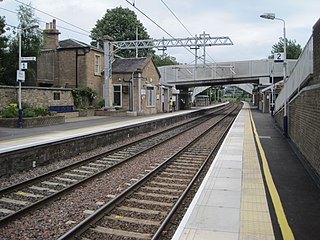
Polmont railway station is a railway station serving the village of Polmont, Scotland as well as the other Falkirk Braes villages. It is located on the Glasgow to Edinburgh via Falkirk Line and is also served by ScotRail services from Edinburgh to Stirling and Dunblane. It is the nearest station to much of the town of Grangemouth.
Falkirk Grahamston railway station is one of two railway stations serving the town of Falkirk in Scotland. It is located on the Edinburgh to Dunblane Line and also the Cumbernauld Line. Train services are provided by ScotRail. The "Highland Chieftain", the daily London North Eastern Railway service from London King's Cross to Inverness and vice versa also calls here.

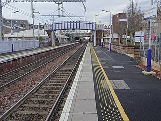
Larbert railway station is a railway station serving Larbert near Falkirk, Scotland.

The Forth and Clyde canal pathway runs between the Firth of Forth and the Firth of Clyde and is a 106-kilometre-long (66 mi) footpath and cycleway that runs across Scotland, between Bowling, west of Glasgow, and Lochrin Basin in Edinburgh. The path runs on the towpaths of the Forth & Clyde and Union Canals and is entirely off road. The path is well maintained and its surface is generally good, although there are some stretches particularly between Falkirk and the outskirts of Edinburgh where wet weather leads to muddy conditions unsuitable for road intended bicycles. It is well used by walkers and cyclists, and designated as one of Scotland's Great Trails by NatureScot. It also forms part of the National Cycle Network, being designated as Route 754. Sustrans advises that the path is best followed from the Clyde to the Forth because the prevailing wind is from the south west. Much of the path is also suitable for experienced horseriders, although in some places low bridges, narrow aqueducts and gates may restrict access for horses.

Torwood is a small village located 2 miles (3.2 km) north-northwest of Larbert, 4 miles (6.4 km) north-west of Falkirk and 6 miles (9.7 km) south-southeast of Stirling. Torwood lies within the Falkirk Council area of Scotland. The population recorded in the 2011 UK Census was 245.
The Grangemouth branch railways served Grangemouth docks on the Firth of Forth, Scotland, connecting the docks to the main line railway network. The first line was opened in 1860. The docks and the branch line developed considerably, and a second branch line was opened in 1911. Grangemouth docks was exceptionally busy during World War I, supplying the Grand Fleet.
The Falkirk Braes is a geographical and sociopolitical entity within the Falkirk local authority area in Scotland. The population is approximately 32,000 (2018), about 20% of the total for Falkirk council area.