
The pied avocet is a large black and white wader in the avocet and stilt family, Recurvirostridae. They breed in temperate Europe and across the Palearctic to Central Asia then on to the Russian Far East. It is a migratory species and most winter in Africa or southern Asia. Some remain to winter in the mildest parts of their range, for example in southern Spain and southern England. The pied avocet is one of the species to which the Agreement on the Conservation of African-Eurasian Migratory Waterbirds (AEWA) applies.

Falkirk is a large town in the Central Lowlands of Scotland, historically within the county of Stirlingshire. It lies in the Forth Valley, 23.3 miles (37.5 km) north-west of Edinburgh and 20.5 miles (33.0 km) north-east of Glasgow.
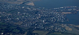
Grangemouth is a town in the Falkirk council area, Scotland. Historically part of the county of Stirlingshire, the town lies in the Forth Valley, on the banks of the Firth of Forth, 3 miles (4.8 km) east of Falkirk, 5 miles (8.0 km) west of Bo'ness and 13 miles (20.9 km) south-east of Stirling. Grangemouth had a resident population of 17,906 according to the 2001 Census. Preliminary figures from the 2011 census reported the number as 17,373.

Stirlingshire or the County of Stirling, Scottish Gaelic: Siorrachd Sruighlea) is a historic county and registration county of Scotland. Its county town is Stirling.

Twechar is a small former mining village historically in Dunbartonshire and administered by the council area of East Dunbartonshire, Scotland close to the boundary with North Lanarkshire. It lies between the larger towns of Cumbernauld, Kilsyth and Kirkintilloch. The Forth and Clyde Canal runs close to the village to the north, and closely follows the line of the Antonine Wall. There are visible remains of the wall on Bar Hill and the Roman Fort is a local tourist attraction.

Dunipace is a village in the west of the Falkirk council area of Scotland. The village is 6.3 miles (10.1 km) south of Stirling and 5.3 miles (8.5 km) north-west of Falkirk. The village is situated on the north bank of the River Carron and adjoins the town of Denny, to the south of the river. Dunipace is part of the historic county of Stirlingshire.

Redding is a village within the Falkirk council area in Central Scotland. The village is 2.1 miles (3.4 km) southeast of Falkirk, 1.9 miles (3.1 km) south-southwest of Grangemouth and 1 mile (1.6 km) west of Polmont.
Camelon is a large settlement within the Falkirk council area, Scotland. The village is in the Forth Valley, 1.3 miles (2.1 km) west of Falkirk, 1.3 miles (2.1 km) south of Larbert and 2.6 miles (4.2 km) east of Bonnybridge. The main road through Camelon is the A803 road which links the village to Falkirk. At the time of the 2001 census, Camelon had a population of 4,508.

Bainsford is a small village within the Falkirk council area of Scotland. The village is situated in the Forth Valley, 1 mile (1.6 km) north of the town of Falkirk. It is positioned between the River Carron and the Forth and Clyde Canal to the north and south respectively.

Slamannan is a village in the south of the Falkirk council area in Central Scotland. It is 4.6 miles (7.4 km) south-west of Falkirk, 6.0 miles (9.7 km) east of Cumbernauld and 7.1 miles (11.4 km) north-east of Airdrie.

Glen Village is a settlement in the Falkirk council area of Scotland, situated at the southern end of Callendar Park, and around 1 mile (1.6 km) south of Falkirk town centre. It adjoins the housing estate of Hallglen, with the two localities counted together in most official statistics.
Shieldhill is a village within the Falkirk council area in Central Scotland. The village is 2.0 miles (3.2 km) south-east of Falkirk, 2.4 miles (3.9 km) south-west of Polmont and 0.5 miles (0.8 km) north of the village of California.

Carronshore is a village in the Falkirk council area of Scotland. The village lies in the Forth Valley, 1.7 miles (2.7 km) north of the town of Falkirk and directly to the east of neighbouring village Carron.

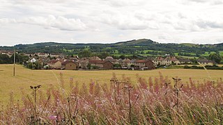
California is a former pit village in the Falkirk council area of Scotland. It lies between Shieldhill and Avonbridge on the uplands which form the southern edge of the council area.
Fallin is a village in the Stirling council area of Scotland. It lies on the A905 road 3 miles east of Stirling on a bend in the River Forth. The United Kingdom Census 2001 recorded the population as 2,710.

Limerigg is a village in the Falkirk council area of Scotland. It lies on the B825 road between Slamannan and Caldercruix surrounded by extensive woodlands on the northern side and lying next to the Black Loch, which formerly fed the Monkland Canal, and close to the former boundary between Stirlingshire and Lanarkshire.
Whitecross is a small village within the Falkirk council area, close to the boundary of West Lothian council in Scotland. It lies 2.0 miles (3.2 km) west-southwest of Linlithgow and 2.5 miles (4.0 km) south-east of Polmont on the west bank of the River Avon. Until the end of World War II it was literally a handful of buildings, but expanded thereafter with a housing estate planned by Stirlingshire County Council in 1945.
South Alloa is a small village which lies in the far north of the Falkirk council area of Scotland. The village is on the south bank of the River Forth where the river empties and widens to form the Firth of Forth.

Carron is a village in the Falkirk council area of Scotland. It is in the Forth Valley, about 2 miles (3.2 km) north of Falkirk, 3 miles (5 km) north-west of Grangemouth and 1⁄2 mile (0.8 km) southeast of Stenhousemuir. Carron is contiguous with village of Carronshore to the east.
The Falkirk Braes is a geographical and sociopolitical entity within the Falkirk local authority area in Scotland. The population is approximately 32,000 (2018), about 20% of the total for Falkirk council area.

