
Stirlingshire or the County of Stirling, Scottish Gaelic: Siorrachd Sruighlea) is a historic county and registration county of Scotland. Its county town is Stirling.

Denny is a town in the Falkirk council area of Scotland. Historically in Stirlingshire, it is situated 7 miles west of Falkirk, and 6 miles (10 km) northeast of Cumbernauld, adjacent to both the M80 and M876 motorways. At the 2011 census, Denny had a resident population of 7,933.

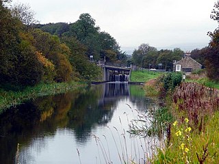
Bonnybridge is a village in the Falkirk council area of Scotland. It is 4.0 miles (6.4 km) west of Falkirk, 5.3 miles (8.5 km) north-east of Cumbernauld and 8.3 miles (13.4 km) south-southwest of Stirling. The village is situated near the Bonny Water which runs through the town and lies north of the Forth and Clyde Canal. To the south-east of Bonnybridge is a well-preserved section of the Antonine Wall, and the remnants of Rough Castle Fort, the most complete of the surviving Roman forts of the wall.

Blackness is a small village and harbour at Blackness Bay, an inlet of the Firth of Forth in Scotland. It lies 3.4 miles (5.5 km) east-southeast of Bo'ness, 5.0 miles (8.0 km) west-northwest of South Queensferry and 3.8 miles (6.1 km) north-east of Linlithgow, within the council area of Falkirk. It was formerly part of the historic county of West Lothian.

Haggs is a small village in the Falkirk council area of Scotland. The village is situated 2.1 miles (3.4 km) south-west of Bonnybridge, 4.6 miles (7.4 km) north-northeast of Kilsyth and 2.0 miles (3.2 km) south-southwest of Denny, on the east side of the M80 motorway which separates it from Banknock.
Banknock is a village within the Falkirk council area in Central Scotland. The village is 6.7 miles (10.8 km) west-southwest of Falkirk, 3.9 miles (6.3 km) east-northeast of Kilsyth and 3.0 miles (4.8 km) north-northeast of Cumbernauld.

Dunipace is a village in the west of the Falkirk council area of Scotland. The village is 6.3 miles (10.1 km) south of Stirling and 5.3 miles (8.5 km) north-west of Falkirk. The village is situated on the north bank of the River Carron and adjoins the town of Denny to the south of the river. Dunipace is part of the historic county of Stirlingshire.

Redding is a village within the Falkirk council area in Central Scotland. The village is 2.1 miles (3.4 km) southeast of Falkirk, 1.9 miles (3.1 km) south-southwest of Grangemouth and 1 mile (1.6 km) west of Polmont.

Westquarter is a village in the Falkirk council area of Scotland. The village is 1 mile (1.6 km) west of Polmont and 1.8 miles (2.9 km) south-east of the town of Falkirk.

Standburn is a small village which lies within the Falkirk council area in central Scotland. It is located 1.3 miles (2.1 km) south-west of Maddiston, 1.7 miles (2.7 km) north-east of Avonbridge and 4.0 miles (6.4 km) south east of Falkirk. The entire village is located along a section of the B825 road between Avonbridge and Loan.

Glen Village is a settlement in the Falkirk council area of Scotland, situated at the southern end of Callendar Park, and around 1 mile (1.6 km) south of Falkirk town centre. It adjoins the housing estate of Hallglen, with the two localities counted together in most official statistics.
Shieldhill is a village within the Falkirk council area in Central Scotland. The village is 2.0 miles (3.2 km) south-east of Falkirk, 2.4 miles (3.9 km) south-west of Polmont and 0.5 miles (0.8 km) north of the village of California.

Maddiston is a village in the Falkirk council area of Scotland. It lies 3.8 miles (6.1 km) west-southwest of Linlithgow, 1.3 miles (2.1 km) south of Polmont and 0.6 miles (1.0 km) south-east of Rumford at the south-east edge of the Falkirk urban area.

Laurieston is a village in the Falkirk council area in Central Scotland. It is 1.5 miles (2.4 km) east Falkirk, 1.6 miles (2.6 km) south-west of Grangemouth and 1.6 miles (2.6 km) west of Polmont.
Skinflats is a small village in the Falkirk council area of Scotland. It is located 1.5 miles (2.4 km) north-west of Grangemouth, 1.1 miles (1.8 km) east of Carronshore and 2.3 miles (3.7 km) north-east of Falkirk. It lies on the A905 road between Glensburgh and Airth, near to the River Carron and the point where it flows into the Firth of Forth.

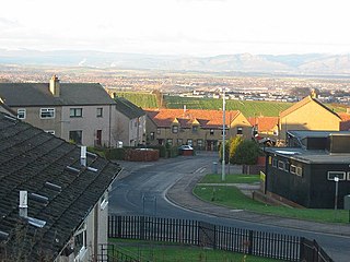
Greenhill is a village which lies in the Falkirk council area of Scotland. The village is located on the outskirts of Bonnybridge, 4.3 miles (6.9 km) west of Falkirk. Greenhill is situated south of the Forth and Clyde Canal and north of the railway line at Greenhill Junction.

Carron is a village in the Falkirk council area of Scotland. It is in the Forth Valley, about 2 miles (3.2 km) north of Falkirk, 3 miles (5 km) north-west of Grangemouth and 1⁄2 mile (0.8 km) southeast of Stenhousemuir. Carron is contiguous with village of Carronshore to the east.

High Bonnybridge is a small village which lies in the Falkirk council area of Scotland. The village is located 0.5 miles (0.8 km) south-east of Bonnybridge and 3.6 miles (5.8 km) west-southwest of Falkirk. High Bonnybridge sits north of the main Glasgow to Edinburgh via Falkirk railway line.

Muirhouses is a small village which lies in the Falkirk council area of Scotland. The village is located 1.1 miles (1.8 km) south-east of Bo'ness, 2.1 miles (3.4 km) north-northeast of Linlithgow and 8.0 miles (12.9 km) east of Falkirk. Muirhouses sits near to the south bank of the Firth of Forth close to the council boundary line between Falkirk and West Lothian councils.

Stoneywood is a small village which lies in the Falkirk council area of Scotland. The village is located 0.1 miles (0.2 km) west of Denny and 7.3 miles (11.7 km) west-northwest of Falkirk.


