Falkirk Braes

Last updated

The Falkirk Braes is a geographical and sociopolitical entity within the Falkirk local authority area in Scotland. The population (both suburban and rural) is approximately 32,000 (2018), about 20% of the total for Falkirk council area. [1] [2]

Contents

Description

Newlands Road, Brightons Newlands Road, Brightons (geograph 5436622).jpg
Newlands Road, Brightons
Westquarter Primary School Westquarter Primary School - geograph.org.uk - 1292184.jpg
Westquarter Primary School
Shops on Polmont Main Street Shops on Polmont main street - geograph.org.uk - 1264404.jpg
Shops on Polmont Main Street
New houses at the Union Canal at Reddingmuirhead, built on former industrial land New houses next to the Union Canal (geograph 5060225).jpg
New houses at the Union Canal at Reddingmuirhead, built on former industrial land
'Tam Bain' public house, Laurieston The Tam Bain, Laurieston (geograph 5404466).jpg
'Tam Bain' public house, Laurieston

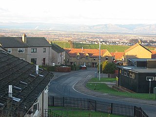
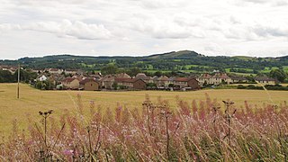
Covering an area of high ground within 5 miles (8.0 km) to the south and east of the county town Falkirk and south of Grangemouth, its core comprises a number of small villages including mining and quarrying communities, [3] [4] [5] which have each expanded to form a near-contiguous acentric suburban environment. [6] Historically within Stirlingshire, most of the Braes villages fell under Grangemouth parish, [7] while Laurieston was part of Falkirk parish [8] and the south-east including Maddiston was in Muiravonside parish. [9] The largest village, with the majority of amenities such as health centre and library, is Polmont, but this is not at the geographical centre of the agglomeration and is itself spread over a wide territory, having grown in several places in different eras. [5] [6] The centre could be argued to be west of Polmont at the site of the Meadowbank Colliery and Brickworks, [10] [11] nominally in Redding; due to its industrial history, it is one of the undeveloped parcels of land in the area.

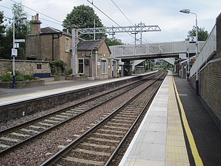
In the 21st century, speculative housebuilding (including on brownfield sites such as the Nobel explosives works), [12] [13] [14] [15] has continued to fill most of the gaps between the settlements, owing to the location falling roughly midway between Glasgow and Edinburgh with links to both cities via the railway network (at Polmont, which falls on the boundary with Brightons) and motorways (M9) as well as employment locally at Falkirk and Grangemouth, which has been highlighted in marketing by developers. [15] [16] [17] [18] [19] [20] [21]

Westquarter Burn Westquarter Burn (geograph 3697273).jpg
Westquarter Burn
Maddiston California Road, Maddiston (geograph 2643350).jpg
Maddiston

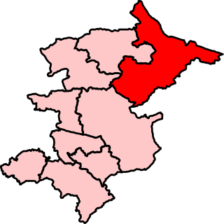
The area returns six representatives to Falkirk Council, three each representing the Lower Braes [22] [23] and Upper Braes [24] [25] wards, divided by the Union Canal which runs east–west through the territory; both wards (particularly Upper Braes) also include outlying rural villages such as Shieldhill, Slamannan and Whitecross in addition to the cluster of villages closer to Falkirk. In wider political contexts, as of 2019 the Braes falls wholly within the Falkirk East constituency at Holyrood, [26] but at Westminster is divided between Linlithgow and East Falkirk [27] and Falkirk. [28]

Braes High School Braes High School (geograph 4353616).jpg
Braes High School

The local secondary school, with approximately 1,000 pupils and six feeder primaries across the Upper Braes, is Braes High School, located in Reddingmuirhead [29] [30] (adjacent to HMYOI Polmont). However, in the Lower Braes the eponymous primary schools in Laurieston, Westquarter and Whitecross, plus St Margaret's Primary in Polmont, are affiliated to Graeme High School in east Falkirk. [31]

Muiravonside Country Park between Maddiston and Whitecross (featuring the Avon Aqueduct) is also within the area. [32] The River Avon flows through the park - it denotes the eastern and southern boundaries of the Braes territory.

List of localities

Displaying 2011 census figures. [33]

Villages in conurbation

Total 22,197

Isolated villages on periphery

See also

Related Research Articles

<span class="mw-page-title-main">Falkirk (council area)</span> Council area of Scotland

Falkirk is one of 32 unitary authority council areas of Scotland. It was formed on 1 April 1996 by way of the Local Government etc. (Scotland) Act 1994 from the exact boundaries of Falkirk District, one of three parts of the Central region created in 1975, which was abolished at that time. Prior to the 1975 reorganisation, the majority of the council area was part of the historic county of Stirlingshire, and a small part, namely Bo'ness and Blackness, was part of the former county of West Lothian.

<span class="mw-page-title-main">Falkirk</span> Town and administrative centre in Scotland

Falkirk is a town in the Central Lowlands of Scotland, historically within the county of Stirlingshire. It lies in the Forth Valley, 23+12 miles northwest of Edinburgh and 20+12 miles (33 km) northeast of Glasgow.

<span class="mw-page-title-main">Stirlingshire</span> Historic county in Scotland

Stirlingshire or the County of Stirling, Scottish Gaelic: Siorrachd Sruighlea) is a historic county and registration county of Scotland. Its county town is Stirling.

<span class="mw-page-title-main">Polmont</span> Human settlement in Scotland

Polmont is a village in the Falkirk council area of Central Scotland. It lies towards the east of the town of Falkirk, north of the Union Canal, which runs adjacent to the village.

<span class="mw-page-title-main">Falkirk (UK Parliament constituency)</span> Parliamentary constituency in the United Kingdom, 2005 onwards

Falkirk is a county constituency of the House of Commons of the Parliament of the United Kingdom. It was created for the 2005 general election, replacing Falkirk West and part of Falkirk East.

<span class="mw-page-title-main">Linlithgow and East Falkirk (UK Parliament constituency)</span> Parliamentary constituency in the United Kingdom, 2005 onwards

Linlithgow and East Falkirk is a county constituency of the House of Commons of the Parliament of the United Kingdom, created for use in the 2005 general election. It replaced most of Falkirk East and Linlithgow.

<span class="mw-page-title-main">Polmont railway station</span> Railway station in Falkirk, Scotland

Polmont railway station is a railway station serving the village of Polmont, Scotland as well as the other Falkirk Braes villages. It is located on the Glasgow to Edinburgh via Falkirk Line and is also served by ScotRail services from Edinburgh to Stirling and Dunblane. It is the nearest station to much of the town of Grangemouth.

<span class="mw-page-title-main">Falkirk East (Scottish Parliament constituency)</span> Region or constituency of the Scottish Parliament

Falkirk East is a constituency of the Scottish Parliament (Holyrood) covering part of the council area of Falkirk. It elects one Member of the Scottish Parliament (MSP) by the plurality method of election. Also, however, it is one of nine constituencies in the Central Scotland electoral region, which elects seven additional members, in addition to nine constituency MSPs, to produce a form of proportional representation for the region as a whole.

<span class="mw-page-title-main">Redding, Falkirk</span> Human settlement in Scotland

Redding is a village within the Falkirk council area in Central Scotland. The village is 2.1 miles (3.4 km) southeast of Falkirk, 1.9 miles (3.1 km) south-southwest of Grangemouth and 1 mile (1.6 km) west of Polmont.

<span class="mw-page-title-main">Brightons</span> Human settlement in Scotland

Brightons is a village in the east of the Falkirk council area of Scotland. It is 2.7 miles (4.3 km) south-east of Falkirk, 2.2 miles (3.5 km) south of Grangemouth and 4.6 miles (7.4 km) east of Linlithgow. It is surrounded by the villages of Polmont, Wallacestone and Rumford. It is central within the Braes area of Falkirk which makes it “Capital of the Braes”

<span class="mw-page-title-main">Westquarter</span> Human settlement in Scotland

Westquarter is a village in the Falkirk council area of Scotland. The village is 1 mile (1.6 km) west of Polmont and 1.8 miles (2.9 km) south-east of the town of Falkirk.

<span class="mw-page-title-main">Reddingmuirhead</span> Human settlement in Scotland

Reddingmuirhead is a village located in Stirlingshire, Falkirk council area, Central Scotland. A few hundred yards uphill from the village of Redding, it is between Shieldhill and Brightons.

<span class="mw-page-title-main">Shieldhill, Falkirk</span> Human settlement in Scotland

Shieldhill is a village within the Falkirk council area in Central Scotland. The village is 2.0 miles (3.2 km) south-east of Falkirk, 2.4 miles (3.9 km) south-west of Polmont and 0.5 miles (0.8 km) north of the village of California.

<span class="mw-page-title-main">California, Falkirk</span> Human settlement in Scotland

California is a former pit village in the Falkirk council area of Scotland. It lies between Shieldhill and Avonbridge on the uplands which form the southern edge of the council area.

<span class="mw-page-title-main">Maddiston</span> Human settlement in Scotland

Maddiston is a village in the Falkirk council area of Scotland. It lies 3.8 miles (6.1 km) west-southwest of Linlithgow, 1.3 miles (2.1 km) south of Polmont and 0.6 miles (1.0 km) south-east of Rumford at the south-east edge of the Falkirk urban area.

<span class="mw-page-title-main">Laurieston, Falkirk</span> Human settlement in Scotland

Laurieston is a village in the Falkirk council area in Central Scotland. It is 1.5 miles (2.4 km) east Falkirk, 1.6 miles (2.6 km) south-west of Grangemouth and 1.6 miles (2.6 km) west of Polmont.

<span class="mw-page-title-main">Whitecross, Falkirk</span> Human settlement in Scotland

Whitecross is a small village within the Falkirk council area, close to the boundary of West Lothian council in Scotland. It lies 2.0 miles (3.2 km) west-southwest of Linlithgow and 2.5 miles (4.0 km) south-east of Polmont on the west bank of the River Avon. Until the end of World War II it was literally a handful of buildings, but expanded thereafter with a housing estate planned by Stirlingshire County Council in 1945.

References

  1. Lower Braes (15,571), Scottish Government Statistics
  2. Upper Braes (16,454), Scottish Government Statistics
  3. Polmont and Brightons, Falkirk Local History Society
  4. OS Six-inch 1st edition, 1843-1882, Explore georeferenced maps (National Library of Scotland)
  5. 1 2 OS 25 inch Scotland, 1892-1905, Explore georeferenced maps (National Library of Scotland)
  6. 1 2 OS National Grid Maps, 1944-1967, Explore georeferenced maps (National Library of Scotland)
  7. Parish of Grangemouth, Gazetteer for Scotland
  8. Parish of Falkirk, Gazetteer for Scotland
  9. Parish of Muiravonside, Gazetteer for Scotland
  10. Stirling 1, Scottish Mining Website
  11. Raewell Firebrick Works, Meadowbank Brickworks, Redding, Falkirk, Stirlingshire, Scottish Brick History
  12. Alfred Nobel in Scotland, NobelPrize.org
  13. Nobels Factory in Redding was an explosive place, Falkirk Herald, 17 April 2012
  14. Polmont, West Quarter And Redding Muir, Detonator Factories, Canmore
  15. 1 2 Residents plead with builders to finish work, Falkirk Herald, 2 April 2009
  16. Starter homes and incentives at Scottish new-build developments, What New Homes?
  17. The Braes Falkirk: Development Overview, Walker Group
  18. Kier Homes to unveil new show home at Redding Bank, Falkirk, easier.com, 2 June 2012
  19. New showhomes to view in Scotland, The Herald, 2 April 2016
  20. [Callendar Rise Phase 8 Web Brochure], Taylor Wimpey
  21. Parkhall Meadow, Persimmon Homes
  22. Lower Braes (Ward 8), Falkirk Council
  23. Lower Braes Local Community Policing Team, Police Scotland
  24. Upper Braes (Ward 9), Falkirk Council
  25. Upper Braes Local Community Policing Team, Police Scotland
  26. Falkirk East: Scottish Parliamentary Constituency (map, 2015), Falkirk Council
  27. Linlithgow and East Falkirk: Westminster Parliamentary Constituency (map, 2015), Falkirk Council
  28. Falkirk: Westminster Parliamentary Constituency (map, 2015), Falkirk Council
  29. Home, Braes High School
  30. Secondary Schools: Braes High School, Falkirk Council
  31. Secondary Schools: Graeme High School, Falkirk Council
  32. Muiravonside Country Park, Falkirk Community Trust
  33. "Insight 2011 Census, No. 6 - Settlement Population and Household Estimates" (PDF). Falkirk Council. Retrieved 4 January 2020.

Coordinates: 55°59′10″N3°43′39″W / 55.986218°N 3.727595°W / 55.986218; -3.727595