Abbotshaugh Community Woodland

Last updated

The historic site of Abbotshaugh Community Woodland, located on the south bank of the River Carron, has witnessed many changes over the past 500 years. The recently planted woodland hopes to recreate a naturally regenerating mature woodland within an area consisting of a mosaic of planted woodland, remnant hedgerows, grassland and saltmarsh. The woodland provides a year-round home for many species including Roe deer, foxes, buzzards and kestrels.

Contents

History

16th and 17th Century (Cartography, Timothy Pont, Joan Blaeu)

The original course of the River Carron can be viewed as a digital image on the National Library of Scotland website. [1] M.S.32, the particular survey of interest is one of many by Timothy Pont who completed a universal survey of Scotland on foot between 1583 and 1614. The work was never published in his lifetime, after Pont's death in 1614 James VI planned to purchase the materials however due to the turbulence of the times they lay forgotten. Sir John Scot, Lord Scotstarvit enlisted Robert Gordon of Straloch and his son James Gordon. In 1641 the surviving manuscripts were carried to Amsterdam, there they revised Pont's maps with the aid of Joan Blaeu. Whilst in Amsterdam in 1645, Sir John Scot dictated from memory the description of several districts, this was accompanied by a Royal letter from Charles I. The works were finally published in the Geographiæ Blaeuaniæ volumen quintum by Joan Blaeu in 1654. Pont's M.S.32 [2] shows the river north of Falkirk, the lands of Abbotshaugh south of the River Carron are marked as "A "east of N. Daldarfe, Joan Blaeu's edition of Stirlingshire [3] shows much the same except for the addition of trees, between the two trees N/E of N. Daldarfe, again the letter "A" can be found, representing Abbotshaugh. This is not clear on the digital images but can be seen on the reproduction maps published jointly by Collins Bartholomew and the Royal Scottish Geographical Society who own one of the original Blaeu's edition of Stirlingshire.

18th Century (Carron Iron Works, Charles Gascoigne, John Ogilvie)

The River Carron of today is man-made [4] and since the destruction of Arthur's O'On has seen many changes, when Carron Iron works was established, they used the river to power their mills and to transport the raw materials and finished products. Charles Gascoigne played a prominent part in the makeup of the river, and the woodlands surrounding the area, he was married to Mary, daughter of Samuel Garbett, a founding partner of Carron Iron Works in 1759. Gascoigne became a partner in Carron Iron Works in 1765, presumably because the Board of Ordinance granted the works a contract to supply armaments to the British Armed Forces in 1764 and he acqustraited the building of parts for James Watt's steam engine in 1765. By this time the Carron Iron Works had come to be at the forefront of the Industrial Revolution, later, boasting the largest Iron works in Europe. [5] In reward, The Carron House [6] was built for him ca. 1759 - 1773 by Francis/Samuel Garbett and Co. [7] He became manager of the Carron Iron Works in 1769 and thus set out to improve the quality of the end product, in 1773 the Carron Iron Works were awarded a Royal Charter however the quality of the pig iron and cast iron had deteriorated to the point where in the same year, 1773, the Royal Navy contracts were cancelled. Thanks to Charles Gascoigne much of the landscape wehe has changed has remained unchanged to this day, as well as straightening the river, lands on both sides of the river were improved and as a consequence brought greater profit to the lairds of the day.

20th and 21st Century (Local Planning, Planting, Correct Naming, The Helix Project)

The first community planting was the result of an advert in The Falkirk Herald . The area planted in March 1996 was the site of Dalderse Mill Farm which was the last working farm in the Dawson ward of Falkirk. The second area planted in March 1998 was Farm Road Community Woodland which incorporated memorial plantings. The third area planted was Cobblebrae Community Woodland in March 2000. All sites were planted as a native mixed woodland.

By 2001 there was some confusion regarding the areas that were planted and so a community group from the Dawson Ward of Falkirk called the Abbotshaugh Alliance was formed to represent the community interest. The name Abbotshaugh was chosen because it is an historically correct name for the land where all the planting took place. The Abbotshaugh Alliance (AA) was then amalgamated into the Abbotshaugh Community Woodlands Group (ACWG).

Abbotshaugh Alliance had an open day for local residents to show support for the local community woodland and at the same time it allowed them to bring up any concerns. A report [8] was written up following the feedback from the day.

From 2004 The Abbotshaugh Community Woodlands Group pushed forward with funding for the local area, garnering interest from around the country The Abbotshaugh Sentinel project. The artist Jephson Robb who was commissioned to design the Sentinel Project took part in a discussion [9] with local residents of the area at Callendar House on 25 April 2012. All of the work carried out by various community groups and organisations throughout the years have led to the vast support and go ahead in the local area for The Helix Project which is situated at the end of the Forth and Clyde Canal. Incorporated into Helix Falkirk is the Helix Cycle Path The Helix Around Town Tour is a 16-mile circular cycle route starting at Falkirk Stadium and connecting The Helix, The Falkirk Wheel and Callendar Park. It has several sections in the Abbotshaugh Community Woodlands.

Further reading

Related Research Articles

<span class="mw-page-title-main">Forth and Clyde Canal</span> Canal crossing central Scotland

The Forth and Clyde Canal is a canal opened in 1790, crossing central Scotland; it provided a route for the seagoing vessels of the day between the Firth of Forth and the Firth of Clyde at the narrowest part of the Scottish Lowlands. This allowed navigation from Edinburgh on the east coast to the port of Glasgow on the west coast. The canal is 35 miles (56 km) long and it runs from the River Carron at Grangemouth to the River Clyde at Bowling, and had an important basin at Port Dundas in Glasgow.

<span class="mw-page-title-main">Grangemouth</span> Town in Scotland

Grangemouth is a town in the Falkirk council area, Scotland. Historically part of the county of Stirlingshire, the town lies in the Forth Valley, on the banks of the Firth of Forth, 3 miles (4.8 km) east of Falkirk, 5 miles (8.0 km) west of Bo'ness and 13 miles (20.9 km) south-east of Stirling. Grangemouth had a resident population of 17,906 according to the 2001 Census. Preliminary figures from the 2011 census reported the number as 17,373.

<span class="mw-page-title-main">Cleland, North Lanarkshire</span> Village in Scotland

Cleland is a village near Motherwell and Wishaw in North Lanarkshire, Scotland,. As of 2018, it has a population of about 3,000. The village has a strong coal mining heritage, and is a typical example of a working class village in North Lanarkshire and the Glasgow area. Due to its location, despite being at the heart of North Lanarkshire, the village is isolated, geographically and culturally, from surrounding towns such as Motherwell, Shotts and Wishaw.

<span class="mw-page-title-main">Larbert</span> Town in Falkirk, Scotland

Larbert is a town in the Falkirk council area of Scotland. The town lies in the Forth Valley above the River Carron which flows from the west. Larbert is three miles from the shoreline of the Firth of Forth and 2+12 miles northwest of Falkirk. Stenhousemuir lies directly east of Larbert, with both settlements being contiguous and sharing certain public amenities with one another.

<span class="mw-page-title-main">Chryston</span> Human settlement in Scotland

Chryston is a village in North Lanarkshire, around 7 miles (11 km) east of Glasgow, in Scotland. It lies north of its sister village, Muirhead, which is on the A80. The village has around double Muirhead's population, although the exact boundary between the two modern villages is difficult to find.

<span class="mw-page-title-main">Joan Blaeu</span> Dutch cartographer (1596–1673)

Joan Blaeu was a Dutch cartographer born in Alkmaar, the son of cartographer Willem Blaeu.

<span class="mw-page-title-main">Carron Company</span> British producer of cast iron products

The Carron Company was an ironworks established in 1759 on the banks of the River Carron near Falkirk, in Stirlingshire, Scotland. After initial problems, the company was at the forefront of the Industrial Revolution in the United Kingdom. The company prospered through its development and production of a new short-range and short-barrelled naval cannon, the carronade. The company was one of the largest iron works in Europe through the 19th century. After 223 years, the company became insolvent in 1982 and was later acquired by the Franke Corporation, being rebranded Carron Phoenix.

<span class="mw-page-title-main">Charles Gascoigne</span> British industrialist

Charles Gascoigne (1737–1806) was British industrialist at the beginning of the Industrial Revolution. Gascoigne was an architect, mechanic, inventor, businessman and industrialist. He spent the final twenty years of his life in the Russian Empire, gaining fame as an engineer-inventor, entrepreneur, and specialist in production.

<span class="mw-page-title-main">River Carron, Forth</span> River in central Scotland

The Carron is a river in central Scotland, rising in the Campsie Fells and flowing along Strathcarron into the Firth of Forth. It has given its name to several locations in Stirlingshire, as well as a type of cannon, a line of bathtubs, two warships, and an island in the Southern Hemisphere.

<span class="mw-page-title-main">Gartcosh</span> Human settlement in Scotland

Gartcosh is a village in North Lanarkshire, Scotland. The village lies about eight miles east of Glasgow, and about one mile northwest of the town of Coatbridge.

Sorbie is a small village in Wigtownshire, Machars, within the administration area of Dumfries and Galloway Council, Scotland.

<span class="mw-page-title-main">Slamannan</span> Human settlement in Scotland

Slamannan is a village in the south of the Falkirk council area in Central Scotland. It is 4.6 miles (7.4 km) south-west of Falkirk, 6.0 miles (9.7 km) east of Cumbernauld and 7.1 miles (11.4 km) north-east of Airdrie.

<span class="mw-page-title-main">The Helix (Falkirk)</span> Bridge

The Helix was a land transformation project to improve the connections between and around 16 communities in Falkirk Council, Scotland, including the eastern end of the Forth and Clyde Canal, and to regenerate the area near where the canal joins the River Carron. The most visible feature of the development is the two unique equine sculptures known as The Kelpies.

<span class="mw-page-title-main">Glenmavis</span> Human settlement in Scotland

Glenmavis is a village in the North Lanarkshire area of Scotland. It is about two miles northwest of Airdrie on the B802 road. It has a population of around 2,200 (2020)

<span class="mw-page-title-main">Longriggend</span>

Longriggend is a village in North Lanarkshire, Scotland, with a population of approximately 200.

<span class="mw-page-title-main">Red Burn</span> Stream in Cumbernauld, Falkirk, Scotland, UK

The Red Burn is one of two main streams which flow out of Cumbernauld. The Scottish New Town’s name derives from the Gaelic for "the meeting of the waters" and there is broad agreement that one of these waters is the Red Burn.

<span class="mw-page-title-main">Bodinbo Island</span>

Bodinbo Island is an islet in the estuarine waters of the River Clyde close to the old ferry slipway at Erskine. Before the dyke or training wall was built the rocky Bodinbo Island was a prominent feature in the river hereabouts and a hazard to shipping, especially sailing craft in the dark, during foggy weather, flood conditions and in high winds. On Ordnance Survey maps the name has been transliterated to Bottombow Island and Boden Boo is the spelling variant used for the nearby woodland plantation.

<i>Blaeu Atlas of Scotland</i> Atlas of Scotland and Ireland published 1654

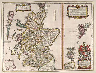
The book commonly known as Blaeu Atlas of Scotland, the fifth volume of Theatrum Orbis Terrarum Sive Atlas Novus, is the first known atlas of Scotland and Ireland. It was compiled by Joan Blaeu, and contains 49 engraved maps and 154 pages of descriptive text written in Latin; it was first published in 1654. Most of the maps were made by Timothy Pont, a Scottish cartographer. Those maps, made between 1583 and 1596, were collected, edited, and augmented with other maps by John Scot, Lord Scotstarvit, a Scottish laird.

<span class="mw-page-title-main">Castle and Lands of Auchruglen</span> Scottish castle

The Castle and Lands of Auchruglen (NS5365436797) was a peel tower in the old district of Kyle held at different times by the Nesbitt and Campbell Clans and located near Newmilns, Parish of Galston, East Ayrshire, Scotland.

References

  1. "View: [The East Central Lowlands (Stirling, Falkirk & Kilsyth)] - Pont 32 - Maps by Timothy Pont". maps.nls.uk. Retrieved 10 July 2016.
  2. "View: [The East Central Lowlands (Stirling, Falkirk & Kilsyth)] - Pont 32 - Maps by Timothy Pont". maps.nls.uk. Retrieved 10 July 2016.
  3. "View: Sterlinensis praefectura, [vulgo], Sterlin-Shyr / Auct. Timoth. Pont. - Blaeu Atlas of Scotland, 1654". maps.nls.uk. Retrieved 10 July 2016.
  4. Lords, Great Britain Parliament House of; Craigie, John; Stewart, John Shaw; Paton, Thomas S. (1 January 1855). Reports of cases decided in the House of lords: upon appeal from Scotland, from 1726 to [1822] ...p61 "ogilvie". T. & T. Clark.
  5. "History".
  6. "Carronshore was once Falkirk's place to be". www.falkirkherald.co.uk. Retrieved 10 July 2016.
  7. Lords, Great Britain Parliament House of; Craigie, John; Stewart, John Shaw; Paton, Thomas S. (1 January 1855). Reports of cases decided in the House of lords: upon appeal from Scotland, from 1726 to [1822] ...pp 61 - 72. T. & T. Clark.
  8. "Search - greenspace scotland". greenspacescotland.org.uk. Archived from the original on 18 August 2016. Retrieved 10 July 2016.
  9. "News". Falkirk Community Trust. Retrieved 10 July 2016.
  10. Lords, Great Britain Parliament House of; Craigie, John; Stewart, John Shaw; Paton, Thomas S. (1 January 1855). Reports of cases decided in the House of lords: upon appeal from Scotland from 1753 to 1813 pp. 61 - 72 Thomas S. Paton. T. & T. Clark.

56°01′22″N3°46′19″W / 56.02278°N 3.77194°W / 56.02278; -3.77194