Barton Swing Aqueduct

Last updated

Barton Swing Aqueduct
Barton Swing Aqueduct.jpg
The aqueduct in the closed position
Coordinates 53°28′29″N2°21′08″W / 53.4748°N 2.3521°W / 53.4748; -2.3521
OS grid reference SJ767976
Carries Bridgewater Canal
Crosses Manchester Ship Canal
Locale Barton upon Irwell
Characteristics
Total length330 feet (101 m)
Traversable?Only narrowboats
Towpaths None
No. of spansTwo (Central Pivot)
History
DesignerSir Edward Leader Williams
Construction end1893
Opened1894
Listed Building – Grade II*
Official nameBarton Bridge, Barton Aqueduct and Control Tower
Designated29 June 1987
Reference no. 1356522
Location
Barton Swing Aqueduct

The Barton Swing Aqueduct is a moveable navigable aqueduct in Barton upon Irwell, Greater Manchester, England. It carries the Bridgewater Canal across the Manchester Ship Canal. The swinging action allows large vessels using the ship canal to pass through and smaller craft, both narrowboats and broad-beam barges, to cross over the top. The aqueduct, the first and only swing aqueduct in the world, [1] is a Grade II* listed building, [2] and considered a major feat of Victorian civil engineering. [2] [3] Designed by Sir Edward Leader Williams and built by Andrew Handyside and Company of Derby, the swing bridge opened in 1894 and remains in regular use. [4]

Contents

History

The Barton Swing Aqueduct is a direct replacement for the earlier Barton Aqueduct, a masonry structure crossing the River Irwell and completed in 1761. The construction of the Manchester Ship Canal in the 1890s necessitated the replacement of this structure, as the height of ships using the new ship canal was too great to pass under the old aqueduct. [5] An alternative scheme involving the use of a double lock flight was rejected, because of the need to conserve water in the Bridgewater Canal above. [6]

The new aqueduct was designed by Sir Edward Leader Williams, [2] engineer to the Manchester Ship Canal Company, and was built by Andrew Handyside and Company of Derby. The first barge crossed the new aqueduct on 21 August 1893, and it opened to commercial traffic on 1 January 1894. [7] Williams was also involved with the Anderton Boat Lift, another moving canal structure in the region.

Construction

Construction work began in 1890, with the demolition of a Roman Catholic school on the south bank of the ship canal. The scale of the operation meant that the course of the River Irwell had to be temporarily diverted around the site, so that the central island could be built on dry land. [8]

Operation

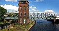
The aqueduct is a form of swing bridge. When closed, it allows canal traffic to pass along the Bridgewater Canal. When large vessels need to pass along the ship canal underneath, the 1,450-tonne (1,430-long-ton; 1,600-short-ton) [3] and 330-foot (100 m) long iron trough [5] is rotated 90 degrees on a pivot mounted on a small purpose-built island. Gates at each end of the trough retain around 800 tonnes of water; additional gates on each bank retain water in their adjacent stretches of canal. [3] The aqueduct originally had a suspended towpath along its length, about 9 feet (2.7 m) above the water level of the Bridgewater Canal, which has now been removed. [9]

The structure is adjacent to, and upstream of, the Barton Road Swing Bridge. Both bridges are operated from a brick control tower on an island in the centre of the ship canal. When in the open position, the aqueduct and road bridge line up along the length of the island, allowing ships to traverse each side. [6] [10] To avoid the risk of collision, the aqueduct is opened half an hour before traffic on the Manchester Ship Canal is scheduled to pass. [11]

Turning mechanism

The turning mechanism built into the central island consists of a 27-foot (8.2 m) race plate embedded in granite blocks. Sixty-four tapered cast iron rollers sat on top of the race plate, held in position by a spider ring. On top of that an upper race plate supports the aqueduct and its circular gear rack, which was powered by a hydraulic engine manufactured by Sir W. G. Armstrong Mitchell of Newcastle.

To reduce the pressure on the turning mechanism, a hydraulic press was installed in the pivot. When water was admitted to the press it took up to half the weight. So successful was this system of hydraulic assistance that Leader Williams retrofitted it to several road swing bridges being built over the Ship Canal including the ones at Stockton Heath and Knutsford Road in Warrington.

The weight of the structure meant that the design was pushing the limits of the possible. This became clear when the sixty-four 35.5 cm (14 inches) mean diameter hollow cast-iron rollers started to deform. By 1927 the structure had dropped by 8.89 cm (3+12 inches). In 1928 the iron rollers were replaced with steel and since then the bridge has dropped by only 2.4mm (3/32-inch). Once the iron rollers were replaced the hydraulic press assistance was dispensed with. [12]

Hydraulic power was originally supplied by steam from two Lancashire boilers housed in a pumping station on the Eccles bank of the ship canal; [13] a service culvert beneath the bed of the canal conveyed the water under pressure to the control tower on the island. [14] In 1939 the original hydraulic engines were replaced by a pair of radial three-cylinder engines manufactured by the Hydraulic Engineering Company of Chester, and the following year a power house was built on the island to house two electrically driven pumps. The old steam pumping station was demolished after the Second World War. [9]

See also

Related Research Articles

<span class="mw-page-title-main">Manchester Bolton & Bury Canal</span> Canal in Greater Manchester, England

The Manchester Bolton & Bury Canal is a disused canal in Greater Manchester, England, built to link Bolton and Bury with Manchester. The canal, when fully opened, was 15 miles 1 furlong (24 km) long. It was accessed via a junction with the River Irwell in Salford. Seventeen locks were required to climb to the summit as it passed through Pendleton, heading northwest to Prestolee before it split northwest to Bolton and northeast to Bury. Between Bolton and Bury the canal was level and required no locks. Six aqueducts were built to allow the canal to cross the rivers Irwell and Tonge and several minor roads.

<span class="mw-page-title-main">James Brindley</span> English canal engineer

James Brindley was an English engineer. He was born in Tunstead, Derbyshire, and lived much of his life in Leek, Staffordshire, becoming one of the most notable engineers of the 18th Century.

<span class="mw-page-title-main">History of the British canal system</span> Building, use, decline and restoration of artificial waterways in the United Kingdom

The canal network of the United Kingdom played a vital role in the Industrial Revolution. The UK was the first country to develop a nationwide canal network which, at its peak, expanded to nearly 4,000 miles in length. The canals allowed raw materials to be transported to a place of manufacture, and finished goods to be transported to consumers, more quickly and cheaply than by a land based route. The canal network was extensive and included feats of civil engineering such as the Anderton Boat Lift, the Manchester Ship Canal, the Worsley Navigable Levels and the Pontcysyllte Aqueduct.

<span class="mw-page-title-main">Manchester Ship Canal</span> UK canal linking Manchester to the coast

The Manchester Ship Canal is a 36 mi-long (58 km) inland waterway in the North West of England linking Manchester to the Irish Sea. Starting at the Mersey Estuary at Eastham, near Ellesmere Port, Cheshire, it generally follows the original routes of the rivers Mersey and Irwell through the historic counties of Cheshire and Lancashire. Several sets of locks lift vessels about 60 ft (18 m) to the canal's terminus in Manchester. Landmarks along its route include the Barton Swing Aqueduct, the world's only swing aqueduct, and Trafford Park, the world's first planned industrial estate and still the largest in Europe.

<span class="mw-page-title-main">Bridgewater Canal</span> Canal in northwest England

The Bridgewater Canal connects Runcorn, Manchester and Leigh, in North West England. It was commissioned by Francis Egerton, 3rd Duke of Bridgewater, to transport coal from his mines in Worsley to Manchester. It was opened in 1761 from Worsley to Manchester, and later extended from Manchester to Runcorn, and then from Worsley to Leigh.

<span class="mw-page-title-main">Castlefield</span> Human settlement in England

Castlefield is an inner-city conservation area in Manchester, North West England. The conservation area which bears its name is bounded by the River Irwell, Quay Street, Deansgate and Chester Road. It was the site of the Roman era fort of Mamucium or Mancunium which gave its name to Manchester. It was the terminus of the Bridgewater Canal, the world's first industrial canal, built in 1764; the oldest canal warehouse opened in 1779. The world's first passenger railway terminated here in 1830, at Liverpool Road railway station and the first railway warehouse opened here in 1831.

<span class="mw-page-title-main">River Weaver</span> River in Cheshire, England

The River Weaver is a river, navigable in its lower reaches, running in a curving route anti-clockwise across west Cheshire, northern England. Improvements to the river to make it navigable were authorised in 1720 and the work, which included eleven locks, was completed in 1732. An unusual clause in the enabling Act of Parliament stipulated that profits should be given to the County of Cheshire for the improvement of roads and bridges, but the navigation was not initially profitable, and it was 1775 before the first payments were made. Trade continued to rise, and by 1845, over £500,000 had been given to the county.

<span class="mw-page-title-main">Canals of the United Kingdom</span> Network of inland waterways

The canals of the United Kingdom are a major part of the network of inland waterways in the United Kingdom. They have a varied history, from use for irrigation and transport, through becoming the focus of the Industrial Revolution, to today's role of recreational boating. Despite a period of abandonment, today the canal system in the United Kingdom is again increasing in use, with abandoned and derelict canals being reopened, and the construction of some new routes. Canals in England and Wales are maintained by navigation authorities. The biggest navigation authorities are the Canal & River Trust and the Environment Agency, but other canals are managed by companies, local authorities or charitable trusts.

<span class="mw-page-title-main">Runcorn Docks</span> Inland port in Cheshire, England

Runcorn Docks, originally the Bridgewater Docks, is an inland port on the Manchester Ship Canal in the town of Runcorn, Cheshire, England. It is operated by Peel Ports and handles bulk and project cargo.

<span class="mw-page-title-main">Navigable aqueduct</span> Man-made channel for water and transport

Navigable aqueducts are bridge structures that carry navigable waterway canals over other rivers, valleys, railways or roads. They are primarily distinguished by their size, carrying a larger cross-section of water than most water-supply aqueducts. Roman aqueducts were used to transport water and were created in Ancient Rome. The 662-metre (2,172 ft) long steel Briare aqueduct carrying the Canal latéral à la Loire over the River Loire was built in 1896. It was ranked as the longest navigable aqueduct in the world for more than a century, until the Magdeburg Water Bridge in Germany took the title in the early 21st century.

<span class="mw-page-title-main">Barton upon Irwell</span> Suburb in Greater Manchester, England

Barton upon Irwell is a suburb of the City of Salford, Greater Manchester, England, with a population of 12,462 in 2014.

<span class="mw-page-title-main">Andrew Handyside and Company</span> Former iron founder company

Andrew Handyside and Company was an iron founder in Derby, England, in the nineteenth century.

<span class="mw-page-title-main">Canals in Cheshire</span>

A large number of canals were built in Cheshire, England, during the early phases of the Industrial Revolution to transport goods and raw materials. This resulted in a significant canal network which is now enjoyed by holiday-makers, anglers, walkers, and others.

<span class="mw-page-title-main">Trafford Park</span> Industrial estate in Greater Manchester, England

Trafford Park is an area of the Metropolitan Borough of Trafford, Greater Manchester, England, opposite Salford Quays on the southern side of the Manchester Ship Canal, 3.4 miles (5.5 km) southwest of Manchester city centre and 1.3 miles (2.1 km) north of Stretford. Until the late 19th century, it was the ancestral home of the Trafford family, who sold it to financier Ernest Terah Hooley in 1896. Occupying an area of 4.7 square miles (12 km2), it was the first planned industrial estate in the world, and remains the largest in Europe well over a century later.

<span class="mw-page-title-main">Manchester and Salford Junction Canal</span>

The Manchester and Salford Junction Canal was a canal in the city of Manchester. It was originally built to provide a direct waterway between the Mersey and Irwell Navigation and the Rochdale Canal. The canal opened in 1839 and was abandoned in 1922.

<span class="mw-page-title-main">Mersey and Irwell Navigation</span> United Kingdom legislation

The Mersey and Irwell Navigation was a river navigation in North West England, which provided a navigable route from the Mersey estuary to Salford and Manchester, by improving the course of the River Irwell and the River Mersey. Eight locks were constructed between 1724 and 1734, and the rivers were improved by the construction of new cuts several times subsequently. Use of the navigation declined from the 1870s, and it was ultimately superseded by the Manchester Ship Canal, the construction of which destroyed most of the Irwell section of the navigation and the long cut between Latchford and Runcorn.

<span class="mw-page-title-main">Runcorn to Latchford Canal</span> Canal in North West England

The Runcorn to Latchford Canal was a man-made canal that ran from Runcorn, to the Latchford area of Warrington. It connected the Mersey and Irwell Navigation to the River Mersey at Runcorn.

<span class="mw-page-title-main">Barton Road Swing Bridge</span> Bridge in Greater Manchester, England

Barton Road Swing Bridge is a swing bridge for road traffic in Greater Manchester that crosses the Manchester Ship Canal between Trafford Park in the Metropolitan Borough of Trafford to Barton-upon-Irwell in the City of Salford. The bridge is a Grade II* listed building, and is part of a surrounding conservation area. It runs parallel to the Barton Swing Aqueduct which carries the Bridgewater Canal. The bridge opens regularly for traffic along the Manchester Ship Canal, which can cause delays for road traffic.

<span class="mw-page-title-main">Barton Aqueduct</span> Former aqueduct over the River Irwell in England

The Barton Aqueduct, opened on 17 July 1761, carried the Bridgewater Canal over the River Irwell at Barton-upon-Irwell, in the historic county of Lancashire, England. Designed largely by James Brindley under the direction of John Gilbert, it was the first navigable aqueduct to be built in England, "one of the seven wonders of the canal age" according to industrial archaeologist Mike Nevell.

The Seven Wonders of the Waterways is a list of landmarks on the navigable waterways of the United Kingdom. The list was originally compiled in 1946 by Robert Aickman, co-founder of the Inland Waterways Association (IWA), at a time when the waterways network was largely derelict. Today, the Canal & River Trust—formerly British Waterways—has jurisdiction over all of the sites except for the Barton Swing Aqueduct, which is owned and operated by the Bridgewater Canal Company.

References

Notes

  1. "Northwest firsts – facts and figures", Industrial Powerhouse, 2009, archived from the original on 3 August 2012, retrieved 5 September 2010
  2. 1 2 3 Historic England, "Barton Swing Aqueduct (1356522)", National Heritage List for England , retrieved 20 January 2008
  3. 1 2 3 "Facts and Figures", Manchester Ship Canal, archived from the original on 5 November 2007, retrieved 1 October 2007
  4. "Barton Swing Aqueduct". Engineering Timelines. Retrieved 28 January 2017.
  5. 1 2 Nevell (1997), p. 135
  6. 1 2 Ryall (2000), p. 686
  7. The Manchester Ship Canal: a brief history. (PDF), Clydeport.co.uk, archived from the original (PDF) on 5 September 2008, retrieved 20 January 2008
  8. Atkinson (2002), pp. 27–28
  9. 1 2 Atkinson (2002), p. 45
  10. "Barton Swing Aqueduct", The Tourist Engineer, 15 June 2008, archived from the original on 17 September 2008, retrieved 20 January 2010
  11. Fisher (2013), p. 236
  12. "The register (2016)".
  13. Atkinson (2002), pp. 41–42.
  14. Atkinson (2002), p. 44
  15. Atkinson (2002), p. 36

Bibliography

Further reading