Salford Civic Centre

Last updated

The Civic Centre
Swinton Town Hall.jpg
Salford Civic Centre
Former namesSwinton and Pendlebury Town Hall
General information
Architectural style Neo-Classical
Location Swinton, City of Salford
Coordinates 53°30′40″N2°20′23″W / 53.5111°N 2.3398°W / 53.5111; -2.3398
Construction started17 October 1936
Completed1938
Cost£80,000
OwnerSalford City Council
Height125 feet
Design and construction
Architect(s)Percy Thomas and Ernest Prestwich

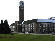
Salford Civic Centre, formerly Swinton and Pendlebury Town Hall, is a municipal building at Chorley Road, in Swinton, Greater Manchester, England. It is the administrative headquarters of Salford City Council.

Contents

History

The Swinton and Pendlebury Urban District Council, which had been formed in 1894, [1] [2] had used Victoria House in Victoria Park as their meeting place. [3] [a] However, after the council became a municipal borough in 1934, it decided to seek larger premises. [3]

The site selected on Chorley Road in Swinton had previously been occupied by Swinton Industrial School. [6] [b] The foundation stone for the new town hall was laid by the mayor on 17 October 1936. [3] The new building was designed by architects Percy Thomas and Ernest Prestwich in the neo-classical style after they had won a national design competition. [3] It was built by J. Gerrard and Sons at a cost of £80,000 and officially opened by the Deputy Leader of the Labour Party, Arthur Greenwood MP, on 17 September 1938. [3] The most striking feature of the design was the clock tower, 125 feet (38 m) in height, with clock faces on each side, 9 feet (2.7 m) in diameter. [3] Percy Thomas was awarded the Royal Institute of British Architects (RIBA) Gold Medal for his work in 1939. [8]

A glass-walled computer centre was built to the south-east of the town hall, in order to cope with increased administration requirements, and completed in July 1973. [3] Following the implementation of the Local Government Act 1972, [9] Swinton and Pendlebury Town Hall, being one of the most modern town halls in the enlarged local authority area, became the meeting place of the enlarged local authority, known as the Salford City Council, in 1974. [3] The council chamber was re-modelled at that time so that it was capable of accommodating a larger number of councillors. [10]

A four-story extension located to the south-west of the town hall, which was designed by Cruickshank and Sewards and built by Fairclough Fram Gerrard, was inspected by the Duke of Edinburgh during construction and completed in the late 1970s. [3] The City Treasury Building, also known as "Unity House", was built by John Laing Group and officially opened by the Shadow Chief Secretary to the Treasury, Margaret Beckett MP, on 9 October 1991. [3]

Following the closure of Kingslea House on Barton Road in 2007, the East Wing of the civic centre became the local register office and as well a venue for weddings and civil partnerships. [11]

In July 2020, during the COVID-19 pandemic, a mural depicting Salford's key workers, which had been painted by an anonymous artist, was left on the steps of the civic centre: council officials decided that it would be put on public display. [12]

Notes

  1. Victoria House dated back at least to the early 19th century; after being re-built in 1862, it was acquired by the council in 1896 and served as council offices until 1938 and then as an adult education centre until it was demolished in 1993. [4] [5]
  2. The local industrial school, which had responsibility for educating local paupers, was opened in 1843; it was visited by Charles Dickens in July 1850, was closed in 1925 and was demolished in 1933. [7]

Related Research Articles

<span class="mw-page-title-main">Salford</span> City in Greater Manchester, England

Salford is a city in Greater Manchester, England, situated on the western bank of the River Irwell which forms its boundary with Manchester city centre. Landmarks in the city include the former town hall, Salford Cathedral, Salford Lads' Club and St Philip's Church. In 2021 it had a population of 129,794. The demonym for people from Salford is Salfordian.

<span class="mw-page-title-main">A6 road (England)</span> North-south road in England

The A6 is one of the main north–south roads in England. It runs from Luton in Bedfordshire to Carlisle in Cumbria, although it formerly started at a junction with the A1 at Barnet in north London, and is described as running from London to Carlisle.

<span class="mw-page-title-main">City of Salford</span> Borough and City in Greater Manchester, England

Salford, also known as the City of Salford, is a metropolitan borough with city status in Greater Manchester, England. The borough is named after its main settlement, Salford, but covers a larger area which includes the towns of Eccles, Swinton, Walkden and Pendlebury. The borough had a population of 278,064 in 2022, and is administered from the Salford Civic Centre in Swinton.

<span class="mw-page-title-main">Worsley</span> Village in Greater Manchester, England

Worsley is a village in the City of Salford, Greater Manchester, England, which in 2014 had a population of 10,090. It lies along Worsley Brook, 6 miles (9.7 km) west of Manchester.

<span class="mw-page-title-main">Prestwich</span> Town in Greater Manchester

Prestwich is a town in the Metropolitan Borough of Bury, Greater Manchester, England, three miles north of Manchester, three miles north of Salford and five miles south of Bury.

<span class="mw-page-title-main">Pendlebury</span> Town in Greater Manchester, England

Pendlebury is a town in the City of Salford, Greater Manchester, England. The population at the 2011 Census was 13,069. It lies 4 miles (6 km) north-west of Manchester, 3 miles (5 km) north-west of Salford and 6 miles (10 km) south-east of Bolton.

<span class="mw-page-title-main">Swinton, Greater Manchester</span> Town in Greater Manchester, England

Swinton is a town in the City of Salford in Greater Manchester, England. southwest of the River Irwell, 4 miles (6.4 km) northwest of Manchester, adjoining the town of Pendlebury and suburb of Clifton. In 2014, it had a population of 22,931.

<span class="mw-page-title-main">Swinton Lions</span> English professional rugby league club

Swinton Lions are a professional rugby league club based in Swinton, Greater Manchester, England, which competes in the Championship. The club has won the Championship six times and three Challenge Cups. Before 1996, the club was known simply as Swinton RLFC.

<span class="mw-page-title-main">Clifton, Greater Manchester</span> Suburb in Greater Manchester

Clifton is a suburb of Swinton, in the Salford district, in Greater Manchester, England. It lies along the edge of Irwell Valley in the north of the City of Salford. Historically in Lancashire, it was a centre for coal mining, and once formed part of the Municipal Borough of Swinton and Pendlebury.

<span class="mw-page-title-main">Municipal Borough of Swinton and Pendlebury</span>

Swinton and Pendlebury was a local government district of the administrative county of Lancashire, England. It was created in 1894 as an urban district and enlarged in 1934, gaining the status of a municipal borough.

<span class="mw-page-title-main">Swinton railway station (Greater Manchester)</span> Railway station in Greater Manchester, England

Swinton railway station serves the towns of Swinton and Pendlebury in the City of Salford, Greater Manchester, England. It is actually located in Pendlebury and not Swinton itself; the boundary between the two districts is about 40 yards further down Station Road (B5231), beyond the junction with Boundary Road and nearer the town centre. It opened, along with the line to passenger trains, in June 1887.

<span class="mw-page-title-main">Pendlebury railway station</span> Former railway station in England

Pendlebury railway station was a station serving the town of Pendlebury in the City of Salford, Greater Manchester, England. It was closed in 1960 by British Railways.

Irlams o' th' Height is a suburb of Salford, Greater Manchester, England, on top of the Irwell Valley, on higher ground than Pendleton, hence the name. The first part of the name derives from the Irlam family that ran the Pack Horse Inn in the 17th and 18th centuries.

<span class="mw-page-title-main">Walkden</span> Town in City of Salford, Greater Manchester, England

Walkden is a town in the City of Salford in Greater Manchester, England, six miles northwest of central Salford, and seven miles of Manchester.

<span class="mw-page-title-main">Wardley, Greater Manchester</span> Human settlement in England

Wardley is a suburban area of the City of Salford, in Greater Manchester, England. It borders Linnyshaw, Walkden and Swinton.

<span class="mw-page-title-main">Percy Thomas</span> English-born architect active in Wales

Sir Percy Edward Thomas OBE was an Anglo-Welsh architect who worked in Wales for the majority of his life. He was twice RIBA president.

<span class="mw-page-title-main">Victoria Park, Swinton</span>

Victoria Park is a park in Swinton, Greater Manchester. Situated on Manchester Road (A6), Swinton, it opened as a public park in 1897.

<span class="mw-page-title-main">Swinton Square</span>

Swinton Square, formerly known as Swinton Shopping Centre, is a shopping centre located between Chorley Road (A6) and Swinton Hall Road in Swinton, near Manchester, England.

<span class="mw-page-title-main">Salford City Council</span> Local government body in England

Salford City Council is the local authority for the City of Salford, a metropolitan borough with city status in Greater Manchester, England. It is a metropolitan borough council and provides the majority of local government services in the city. The council has been a member of the Greater Manchester Combined Authority since 2011.

<span class="mw-page-title-main">Salford Town Hall</span> Municipal building in Salford, Greater Manchester, England

Salford Town Hall is the former town hall of Salford, Greater Manchester, England. It was the meeting place of the County Borough of Salford. Following the abolition of the county borough, it became Salford Magistrates' Court and continued to be used as such until 2011. The court was then merged with the court of Manchester to form the Manchester and Salford Magistrates' Court. The building is now in residential use and is a Grade II Listed Building being designated in January 1952.

References

  1. Farrer, William; Brownbill, J. (1911). "'Townships: Worsley', in A History of the County of Lancaster". London: British History Online. pp. 376–392. Retrieved 8 August 2020.
  2. Dickens, Steven (2015). Eccles and Swinton Through Time. Amberley Publishing. ISBN   978-1445620947.
  3. 1 2 3 4 5 6 7 8 9 10 "Civic Centre history". Salford City Council. Retrieved 8 August 2020.
  4. Leek, Lizzie. "Swinton Hall" . Retrieved 8 August 2020.
  5. "Victoria Park Management Plan 2009-2013". Salford City Council. p. 7. Retrieved 8 August 2020.
  6. "Swinton Industrial School - how paupers were educated in 19th-century Manchester". BBC. Retrieved 8 August 2020.
  7. Leek, Lizzie. "Swinton Industrial School" . Retrieved 8 August 2020.
  8. RIBA website RIBA Gold Medallists 1848-2008 Archived 2014-02-02 at the Wayback Machine (viewed 2011-11-13)
  9. "Local Government Act 1972". Legislation.gov.uk. Retrieved 22 April 2020.
  10. "Swinton Town Hall". Architects of Greater Manchester. Retrieved 8 August 2020.
  11. "Brides marry in the White House". Manchester Evening News. 19 July 2007. Retrieved 8 August 2020.
  12. "Coronavirus: 'Stunning' artwork pays tribute to Salford key workers". BBC. 7 July 2020. Retrieved 8 August 2020.