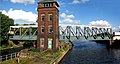
Barton Road Swing Bridge | |
|---|---|
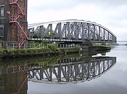 The bridge in an open position, allowing traffic to pass through the Manchester Ship Canal | |
| Coordinates | 53°28′28″N2°21′12″W / 53.4744°N 2.3533°W |
| Carries | Road traffic |
| Crosses | Manchester Ship Canal [1] |
| Locale | Greater Manchester, England [1] |
| Characteristics | |
| Design | Swing truss bridge [1] |
| Material | Steel [1] |
| Total length | 59.3 metres (195 ft) |
| Width | 5.6 metres (18 ft) |
| History | |
| Constructed by | Edward Leader Williams (design) Andrew Handyside and Company (construction) |
| Opened | 1 January 1894 |
Listed Building – Grade II* | |
| Official name | Barton Bridge, Barton Aqueduct and Control Tower |
| Designated | 29 June 1987 |
| Reference no. | 1356522 |
| Location | |
 | |
Barton Road Swing Bridge (or Barton Road Bridge) is a swing bridge for road traffic in Greater Manchester that crosses the Manchester Ship Canal between Trafford Park in the Metropolitan Borough of Trafford to Barton-upon-Irwell in the City of Salford. The bridge is a Grade II* listed building, [2] [3] and is part of a surrounding conservation area. It runs parallel to the Barton Swing Aqueduct which carries the Bridgewater Canal. The bridge opens regularly for traffic along the Manchester Ship Canal, which can cause delays for road traffic.
Contents
The bridge and aqueduct were inaugurated along with the Manchester Ship Canal in 1894, though a bridge had previously existed at this location for over 200 years. During the 20th century, it became increasingly important as an access route to Trafford Park and to allow traffic to bypass Manchester and Salford city centres, and consequently became a significant traffic bottleneck. A replacement high level bridge was built further downstream, and today the swing bridge carries mostly local traffic.