
Altrincham is a market town in Trafford, Greater Manchester, England, south of the River Mersey. It is 8 miles (13 km) southwest of Manchester, 3 miles (5 km) southwest of Sale and 10 miles (16 km) east of Warrington. At the 2011 census, it had a population of 52,419.

Trafford is a metropolitan borough of Greater Manchester, England, with an estimated population of 235,493 in 2017. It covers 41 square miles (106 km2) and includes the area of Old Trafford and the towns of Altrincham, Stretford, Urmston, Partington and Sale. The borough was formed in 1974 as a merger of six former districts and part of a seventh. The River Mersey flows through the borough, separating North Trafford from South Trafford, and the historic counties of Lancashire and Cheshire. Trafford is the fifth-most populous district in Greater Manchester.

Sale is a town in Trafford, Greater Manchester, England, in the historic county of Cheshire on the south bank of the River Mersey, 2 miles (3.2 km) south of Stretford, 3 miles (4.8 km) northeast of Altrincham, and 5 miles (8.0 km) southwest of Manchester. In 2011, it had a population of 134,022, making it the largest town by population in Trafford.
Stretford is a market town in Trafford, Greater Manchester, England. It is situated on flat ground between the River Mersey and the Manchester Ship Canal, 3.8 miles (6.1 km) south of Manchester city centre, 3.0 miles (4.8 km) south of Salford and 4.2 miles (6.8 km) north-east of Altrincham. Stretford borders Chorlton-cum-Hardy to the east, Moss Side and Whalley Range to the south-east, Hulme to the north-east, Urmston to the west, Salford to the north, and Sale to the south. The Bridgewater Canal bisects the town.

Urmston is a town in Trafford, Greater Manchester, England, which had a population of 41,825 at the 2011 Census. Historically in Lancashire, it is 5 miles (8 km) southwest of Manchester city centre. The southern boundary is the River Mersey, with Stretford lying to the east and Flixton to the west. Davyhulme lies to the north of the town centre. Urmston covers an area of 4,799 acres (19.42 km2).
Hale Barns is a village near Altrincham in Greater Manchester, England, 7 miles (11 km) south-west of Manchester city centre, 2 miles west of Manchester Airport and close to the River Bollin. At the 2011 census, the village had a population of 9,736.

Partington is a town and civil parish in the Metropolitan Borough of Trafford, Greater Manchester, England, ten miles (16 km) south-west of Manchester city centre. Within the boundaries of the historic county of Cheshire, it lies on the southern bank of the Manchester Ship Canal, opposite Cadishead on the northern bank. It has a population of 7,327.

Dunham Massey is a civil parish in the Metropolitan Borough of Trafford, Greater Manchester, England. The parish includes the villages of Sinderland Green, Dunham Woodhouses and Dunham Town, along with Dunham Massey Hall and Park, formerly the home of the last Earl of Stamford and owned by the National Trust since 1976. Dunham Massey is in the historic county of Cheshire, but since 1974 has been part of Trafford Metropolitan Borough; the nearest town is Altrincham. At the 2001 census, the parish had a population of 475.
King's College Guildford is an academy comprising a secondary school in Guildford, Surrey, England. It has around 500 pupils.
Solihull is a large market town, and seat of the wider Metropolitan Borough of Solihull in the West Midlands County, England. Solihull is situated on the River Blythe in the Forest of Arden area. The town had a population of 126,577 at the 2021 Census, and its wider borough had a population of 216,240 The town is located 7.5 miles southeast of Birmingham, 13 miles west of Coventry, 18 miles northwest of Warwick and 110 miles northwest of London.
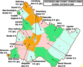
The Penn-Trafford School District is a public school district that serves western Westmoreland County, Pennsylvania and a small portion of Allegheny County, Pennsylvania. The district is governed by a locally elected, nine member school board who serve, staggered four-year terms, the Pennsylvania General Assembly and the Pennsylvania Department of Education. The district neighbors 7 other school districts: Franklin Regional, Greensburg-Salem, Hempfield Area, Jeannette City, Norwin, Gateway, and East Allegheny. The district mascot is the Warrior.

Pollards Hill is a small residential district straddling south London boroughs of Croydon and Merton between Mitcham, Norbury and Thornton Heath. The boundary of the two boroughs is a street named Recreation Way. No roads directly cross the Croydon and Merton divide, and streets were planned according to borough, leading to differing architectural or building schemes. It lends its name to a ward of the London Borough of Merton.

Oasis Academy Coulsdon, formerly known as Coulsdon High School, is a school in the London Borough of Croydon, England. It is between the area of Coulsdon and Caterham. It is an academy run by the Christian charity Oasis Trust. The conversion to an academy in 2008 attracted a £20 million investment over five years by the government, via the Oasis Trust.
Penn-Trafford High School is a public high school located in Harrison City, Pennsylvania in Westmoreland County, and is the secondary school serving the Penn-Trafford School District. It is the result of several mergers of smaller school districts and entities. It is the successor of Penn Joint High School and Trafford High School. The school colors are green and gold. The different government entities that are incorporated into this school district are, in size order, Penn Township, Trafford Borough, Manor Borough (part), and Penn Borough. The school district is mainly in Westmoreland County, Pennsylvania with a small part of Trafford Borough in Allegheny County, Pennsylvania.
The Sittingbourne School is a secondary school and sixth form with academy status located in Sittingbourne, Kent, with around 1600 students.

Standish Community High School – known locally as Standish High – is a coeducational secondary school located in Standish in the Metropolitan Borough of Wigan, Greater Manchester, England.
Broadoak School is a coeducational secondary school with academy status located in Partington in the English county of Greater Manchester.

Bohunt School Worthing (BSW) is an 11–16 mixed secondary school with academy status in Worthing, West Sussex, England. It was established in September 2015 and is part of the Bohunt Education Trust. The school opened as part of the change of age of transfer arrangements in Worthing, which saw an end to three-tier education in the town.
