Flixton House

Last updated

Flixton House
Flixton house late afternoon.jpg
Flixton House in Summer 2003
Flixton House
General information
StatusGrade II Listed Building
LocationFlixton,Trafford
AddressFlixton Rd, Urmston, Manchester M41 5GJ
Coordinates 53°26′44″N2°23′0″W / 53.44556°N 2.38333°W / 53.44556; -2.38333 Coordinates: 53°26′44″N2°23′0″W / 53.44556°N 2.38333°W / 53.44556; -2.38333
LandlordTrafford Council
Website
http://www.flixtonhouse.co.uk/Home.aspx

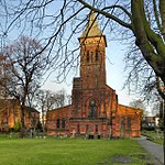
Flixton House was built in 1806 by the Wright family, who had become wealthy land owners in Flixton.

Contents

Flixton House would probably have been quite unremarkable in a national context had Ralph Wright in 1826 not closed several footpaths across his estate, footpaths that the public had until then been allowed access to.

In response to the closure of those footpaths the people of Flixton initiated and funded a court case against Ralph Wright, one of the first footpath battles in England. [1]

The people of Flixton won their case, and their success led to the creation of the Manchester Association for the Preservation of Ancient Footpaths in 1826.

Subsequent history

The Wright family continued to hold the house and land until the death of Samuel Worthington-Wright in 1934, following which Urmston Urban District Council acquired Flixton House and its 218 acres (0.88 km2) of land for £69,793.

The park was officially opened to the public in 1935. The house and park are now owned by Trafford Council.

Flixton House along with its surrounding buildings was designated a Grade II listed building in 1981.

Event Space

This Grade II listed building has been a wedding and events venue in Trafford for many years and is now owned and managed by Trafford Council.

In 2018 Flixton House recently underwent a drastic refurbishment. The venue has been updated with modern décor and furnishings whilst retaining many features from the early 19th century.

Related Research Articles

Trafford Borough of Greater Manchester, England

Trafford is a metropolitan borough of Greater Manchester, England, with an estimated population of 235,493 in 2017. It covers 41 square miles (106 km2) and includes the area of Old Trafford and the towns of Altrincham, Stretford, Urmston, Partington and Sale. The borough was formed in 1974 as a merger of the municipal boroughs of Timperley, Sale, and Stretford, the urban districts of Bowdon, Hale and Urmston and part of Bucklow Rural District. The River Mersey flows through the borough, separating North Trafford from South Trafford, and the historic counties of Lancashire and Cheshire.

Harlow Town and local government district in England

Harlow is a town and local government district in the west of Essex, England. Founded as a new town, it is situated on the border with Hertfordshire and London, Harlow occupies a large area of land on the south bank of the upper Stort Valley, which has been made navigable through other towns and features a canal section near its watermill. Old Harlow is a historic village founded by the early medieval age and most of its high street buildings are early Victorian and residential, mostly protected by one of the Conservation Areas in the district. In Old Harlow is a field named Harlowbury, a de-settled monastic area which has the remains of a chapel, a scheduled ancient monument.

Sale, Greater Manchester Town in Greater Manchester, England

Sale is a town in Trafford, Greater Manchester, England. Located in the historic county of Cheshire on the south bank of the River Mersey, 2 miles (3.2 km) south of Stretford, 3 miles (4.8 km) northeast of Altrincham, and 5 miles (8.0 km) southwest of Manchester. In 2011, it had a population of 134,022, making it the largest town by population in Trafford.

Wolverton Human settlement in England

Wolverton is a constituent town of Milton Keynes, England. It is located at the northern edge of Milton Keynes, beside the West Coast Main Line, the Grand Union Canal and the river Great Ouse. It is the administrative seat of Wolverton and Greenleys civil parish.

Stretford Town in Greater Manchester, England

Stretford is a market town in Trafford, Greater Manchester, England, on flat ground between the River Mersey and the Manchester Ship Canal, 3.8 miles (6.1 km) south of Manchester city centre, 3.0 miles (4.8 km) south of Salford and 4.2 miles (6.8 km) northeast of Altrincham. Stretford borders Chorlton-cum-Hardy to the east, Moss Side and Whalley Range to the southeast, Hulme to the northeast, Urmston to the west, Salford to the north, and Sale to the south. The Bridgewater Canal bisects the town.

Urmston Town in Greater Manchester, England

Urmston is a town in Trafford, Greater Manchester, England, which had a population of 41,825 at the 2011 Census. Historically in Lancashire, it is 5 miles (8 km) southwest of Manchester city centre. The southern boundary is the River Mersey, with Stretford lying to the east and Flixton to the west. Davyhulme lies to the north of the town centre. Urmston covers an area of 4,799 acres (19 km2).

Clayton is a suburb of Manchester, England, 3 miles east of the city centre on Ashton New Road.

Whirlow Suburb of Sheffield, South Yorkshire, England

Whirlow is a suburb of the City of Sheffield in England, it lies 3.7 miles (6 km) south-west of the city centre. The suburb falls within the Dore and Totley ward of the City. It is one of the most affluent areas of Sheffield, with much high class housing and several notable small country houses within it. During the Victorian era it was home to some of Sheffield's most influential citizens. Whirlow straddles the A625, the main Sheffield to Hathersage road. The suburb covers the area from Parkhead in the north to Whirlow Bridge in the south and from Ecclesall Woods in the east to Broad Elms Lane in the west. Whirlow had a population of 1,663 in 2011.

Heaton Park Municipal park in Manchester, England

Heaton Park is a municipal park in Manchester, England, covering an area of over 600 acres (242.8 ha). The park includes the grounds of a Grade I listed, neoclassical 18th century country house, Heaton Hall. The hall, remodelled by James Wyatt in 1772, is now only open to the public on an occasional basis as a museum and events venue.

Avenue House

Avenue House is a large Victorian mansion situated on East End Road in Finchley in the London Borough of Barnet.

Codnor Castle

Codnor Castle is a ruined 13th-century castle in Derbyshire, England. The land around Codnor came under the jurisdiction of William Peverel after the Norman conquest. The building is registered as a Scheduled Ancient Monument a Grade II Listed Building and is officially a Building at Risk.

Acton, Cheshire Human settlement in England

Acton is a small village and civil parish lying immediately west of the town of Nantwich in the unitary authority of Cheshire East and the ceremonial county of Cheshire, England. The civil parish covers 762 acres (3.08 km2) and also includes the small settlement of Dorfold and part of Burford, with an estimated population of 340 in 2006. It is administered jointly with the adjacent civil parishes of Henhull and Edleston. Historically, Acton refers to a township and also to an ancient parish in the Nantwich Hundred covering a wide area to the west of Nantwich. The area is agricultural, with dairy farming the main industry. Around a third of the area falls within the Dorfold Estate. Historically, agriculture was the major employer, but it has now been overtaken by the service industries, with many residents commuting significant distances outside the parish to work.

Northiam Human settlement in England

Northiam is a village and civil parish in the Rother district, in East Sussex, England, 13 miles (21 km) north of Hastings in the valley of the River Rother. The A28 road to Canterbury and Hastings passes through it.

Flixton, Greater Manchester Human settlement in England

Flixton is a suburb and electoral ward in the Metropolitan Borough of Trafford, Greater Manchester, England. The population of the ward at the 2011 census was 10,786. It lies six miles (9.7 km) southwest of Manchester city centre, in the historic county of Lancashire.

Wonersh Human settlement in England

Wonersh is a village and civil parish in the Waverley district of Surrey, England and Surrey Hills Area of Outstanding Natural Beauty. Wonersh contains three Conservation Areas and spans an area three to six miles SSE of Guildford. In the outer London commuter belt, the village is 28 miles (45 km) southwest of London. Wonersh's economy is predominantly a service sector economy. Three architecturally-listed churches are within its boundaries as are a number of notable homes such as Frank Cook's 1905 hilltop mansion, which is a hotel, business and wedding venue.

Meersbrook Park

Meersbrook Park is set on a steep hillside in Meersbrook, Sheffield, England, offering panoramic views over central Sheffield to the north. Within the park are two historic buildings: Bishops' House and Meersbrook Hall.

Albury Park

Albury Park is a country park and Grade II* listed historic country house in Surrey, England. It covers over 150 acres (0.61 km2); within this area is the old village of Albury, which consists of three or four houses and a church. The River Tillingbourne runs through the grounds. The gardens of Albury Park are Grade I listed on the Register of Historic Parks and Gardens.

Milton, Vale of White Horse Human settlement in England

Milton is a village and civil parish about 3 miles (5 km) west of Didcot and a similar distance south of Abingdon. The 2011 Census recorded the parish's population as 1,290.

Warnford Human settlement in England

Warnford is a village and civil parish in the City of Winchester district of Hampshire, England. The parish covers 1283 hectares. The population in 2019 was estimated at 220.

St Cross South Elmham Human settlement in England

St Cross South Elmham is a village and civil parish in the north of the English county of Suffolk. It is in the East Suffolk district, close to the border with Norfolk and is 3 miles (4.8 km) east of Harleston and 4.25 miles (6.84 km) south-west of Bungay. It is one of the villages around Bungay known as the Saints.

References

  1. "2002 - 2006 Management & Improvement Plan (Working Document)". Trafford Metropolitan Borough Council. Archived from the original (PDF) on 27 September 2007. Retrieved 23 April 2007.