Sale Town Hall

Last updated

Sale Town Hall
Sale Town Hall - geograph.org.uk - 1749852.jpg
Sale Town Hall
LocationSchool Road, Sale
Coordinates 53°25′30″N2°19′11″W / 53.4250°N 2.3197°W / 53.4250; -2.3197 Coordinates: 53°25′30″N2°19′11″W / 53.4250°N 2.3197°W / 53.4250; -2.3197
Built1915
Architectural style(s) Neoclassical style
Greater Manchester UK location map 2.svg
Red pog.svg
Shown in Greater Manchester

Sale Town Hall is a municipal building in School Road, Sale, Greater Manchester, England. The town hall was the headquarters of Sale Borough Council until the council was abolished in 1974.

History

After rapid development as a commuter town, which saw its population tripling by the end of the 19th century, [1] Sale became an urban district in 1894. [2] Civic leaders decided to procure a town hall and the site they selected on the north side of School Road had already been occupied by local council offices. [3]

The foundation stone for the new building (the eastern wing of the main frontage) was laid by the Chairman of the Public Offices Committee, James McDonald, on 9 May 1914. [4] It was designed in the neoclassical style in red brick and was officially opened by the Chairman of the council, Ernest Jones, on 4 December 1915. [4] A war memorial, which depicted a mourning Saint George on top of a stone pedestal, was designed by Arthur Sherwood Edwards to commemorate local service personnel who had died in the First World War and was unveiled by Major-General Arthur Solly-Flood on 23 May 1925. [5] [6]

After Sale became a municipal borough in September 1935, civic leaders decided to extend the building. The foundation stone for the extension (the western wing of the main frontage) was laid by the Chairman of the Public Offices Committee, Alderman Paley Parrish, on 5 May 1937. [7] It was designed in a similar style and was officially opened by the mayor, Alderman G. F. Gordon, on 2 July 1940. [7] By this time, the design involved a symmetrical main frontage with nine bays facing onto School Road; the central section of seven bays, which slightly projected forward, incorporated a central bay which was faced with stone and featured a doorway on the ground floor with stone brackets supporting an entablature bearing the words "Sale Town Hall" and a coat of arms and balcony above; there was a French door, which was recessed, on the first floor and a pediment above. Sale Library on Tatton Road, which had been based just behind the town hall extension, was rebuilt around the same time. [8] Internally, the principal room in the town hall was the council chamber which was panelled and was decorated in an Art Deco style. [9]

The building was hit by a series of German incendiary bombs on the night of 23 December 1940 during the Manchester Blitz, a part of the Second World War: [10] there were no injuries but the building was badly damaged. [11] A programme of restoration works, which included the installation of a new clock tower with cupola, was completed in 1952. The works included the re-instatement of a stained glass window on the main staircase depicting the coat of arms of the former local member of parliament, Sir William Cunliffe Brooks. [12]

The town hall continued to serve as the headquarters of Sale Borough Council for much of the 20th century but ceased to be the local seat of government when the enlarged Trafford Council was formed in 1974. [13] A further programme of works to refurbish the town hall, the library and the civic theatre was completed in November 2004. [10] The works involved the conversion of the civic theatre into the new Waterside Arts Centre and the creation of the Robert Bolt Theatre, named after the playwright and a twice Oscar-winning screenwriter, Robert Bolt, behind the east wing of the town hall. [10] [9]

Related Research Articles

Altrincham Town in Greater Manchester, England

Altrincham is a market town in Trafford, Greater Manchester, England, south of the River Mersey. It is 8 miles (13 km) southwest of Manchester city centre, 3 miles (5 km) southwest of Sale and 10 miles (16 km) east of Warrington. At the 2011 Census, it had a population of 52,419.

Trafford Borough of Greater Manchester, England

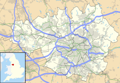
Trafford is a metropolitan borough of Greater Manchester, England, with an estimated population of 235,493 in 2017. It covers 41 square miles (106 km2) and includes the area of Old Trafford and the towns of Altrincham, Stretford, Urmston, Partington and Sale. The borough was formed in 1974 as a merger of the municipal boroughs of Timperley, Sale, and Stretford, the urban districts of Bowdon, Hale and Urmston and part of Bucklow Rural District. The River Mersey flows through the borough, separating North Trafford from South Trafford, and the historic counties of Lancashire and Cheshire.

Sale, Greater Manchester Town in Greater Manchester, England

Sale is a town in Trafford, Greater Manchester, England. Located in the historic county of Cheshire on the south bank of the River Mersey, 2 miles (3.2 km) south of Stretford, 3 miles (4.8 km) northeast of Altrincham, and 5 miles (8.0 km) southwest of Manchester. In 2011, it had a population of 134,022, making it the largest town by population in Trafford.

Stretford Town in Greater Manchester, England

Stretford is a market town in Trafford, Greater Manchester, England, on flat ground between the River Mersey and the Manchester Ship Canal, 3.8 miles (6.1 km) south of Manchester city centre, 3.0 miles (4.8 km) south of Salford and 4.2 miles (6.8 km) northeast of Altrincham. Stretford borders Chorlton-cum-Hardy to the east, Moss Side and Whalley Range to the southeast, Hulme to the northeast, Urmston to the west, Salford to the north, and Sale to the south. The Bridgewater Canal bisects the town.

Trafford Town Hall Municipal building in Trafford, Greater Manchester, England

Trafford Town Hall is a neo-classical building in the borough of Trafford, Greater Manchester. It houses Trafford Council and a number of other local government authorities. The building faces Emirates Old Trafford to the south and is within 500 metres of Manchester United's Football Ground to the north.

Bromley Town Hall Municipal building in London, England

Bromley Town Hall is a municipal building in Tweedy Road, Bromley, London. Built in 1906, it is a Grade II listed building.

Bermondsey Town Hall Municipal building in London, England

Bermondsey Town Hall is a municipal building in Spa Road, Bermondsey, London. It is a Grade II listed building.

Poplar Town Hall Municipal building in London, England

Poplar Town Hall is a municipal building at the corner of Bow Road and Fairfield Road in Poplar, London. It is a Grade II listed building.

Poole Civic Centre Municipal building in Poole, Dorset, England

Poole Civic Centre is an Art Deco municipal building in Poole, Dorset. Since 7 October 2019 the building has been a Grade II listed building. Also sometimes known as Poole Town Hall, the civic centre was the headquarters of Poole Borough Council until 2019.

Bridlington Town Hall Municipal building in Bridlington, East Riding of Yorkshire, England

Bridlington Town Hall is a municipal building in Quay Road, Bridlington, East Riding of Yorkshire, England. The town hall, which was the meeting place of Bridlington Borough Council, is a Grade II listed building.

Brighouse Town Hall Municipal building in West Yorkshire, England

Brighouse Town Hall is a former municipal building in Thornton Square, Brighouse, West Yorkshire, England. The town hall, which was the headquarters of Brighouse Borough Council, is a Grade II listed building.

Ossett Town Hall Municipal building in West Yorkshire, England

Ossett Town Hall is a municipal building in the Market Place, Ossett, West Yorkshire, England. The town hall, which was the headquarters of Ossett Borough Council is a grade II listed building.

Dukinfield Town Hall Municipal building in Dukinfield, Greater Manchester, England

Dukinfield Town Hall is a municipal building in King Street, Dukinfield, Greater Manchester, England. The town hall, which was the headquarters of Dukinfield Borough Council, is a grade II listed building.

Farnworth Town Hall Municipal building in Farnworth, Greater Manchester, England

Farnworth Town Hall is a municipal building in Market Street, Farnworth, Greater Manchester, England. The town hall, which was the headquarters of Farnworth Borough Council, is a grade II listed building.

Retford Town Hall Municipal building in Retford, Nottinghamshire, England

Retford Town Hall is a municipal building in The Square, Retford, Nottinghamshire, England. The town hall, which was the meeting place of Retford Borough Council, is a grade II listed building.

Ripley Town Hall Municipal building in Ripley, Derbyshire, England

Ripley Town Hall is a municipal building in the Market Place, Ripley, Derbyshire, England. The town hall is the headquarters of Amber Valley Borough Council.

Tunbridge Wells Town Hall Municipal building in Tunbridge Wells, Kent, England

Tunbridge Wells Town Hall is a municipal building in Mount Pleasant Road, Royal Tunbridge Wells, Kent, England. The town hall, which is the headquarters of Tunbridge Wells Borough Council, is a Grade II listed building.

Altrincham Town Hall Municipal building in Altrincham, Greater Manchester, England

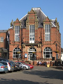
Altrincham Town Hall is a municipal building in Market Street, Altrincham, Greater Manchester, England. The town hall was the headquarters of Altrincham Borough Council.

Wednesbury Town Hall Municipal Building in England

Wednesbury Town Hall is a municipal building in Holyhead Road in Wednesbury, West Midlands, England. The structure, which was the meeting place of Wednesbury Borough Council, now operates as an events venue.

Morpeth Town Hall Municipal building in Morpeth, Northumberland, England

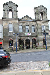
Morpeth Town Hall is a municipal building in the Market Place, Morpeth, Northumberland, England. The structure, which was the meeting place of Morpeth Borough Council, is a Grade II listed building.

References

  1. Nevell, Mike (1997). The Archaeology of Trafford. Trafford Metropolitan Borough Council. p. 87. ISBN   1-870695-25-9.
  2. "Sale UD/MB", Vision of Britain, University of Portsmouth , retrieved 17 August 2008
  3. "Ordnance Survey Map". 1898. Retrieved 4 January 2021.
  4. 1 2 "Plaques on the Eastern Wing of the Town Hall" . Retrieved 4 January 2021.
  5. "Sale and Ashton upon Mersey Memorial". Imperial War Museum. Retrieved 4 January 2021.
  6. Historic England. "War Memorial, Sale (1067896)". National Heritage List for England . Retrieved 4 January 2021.
  7. 1 2 "Plaques on the Western Wing of the Town Hall" . Retrieved 4 January 2021.
  8. "A look back in time". Messenger Newspapers. 6 January 2000. Retrieved 4 January 2021.
  9. 1 2 "About us". Waterside Arts. Retrieved 5 January 2020.
  10. 1 2 3 "Part One - Location, History, Famous Residents and Further Reading". The Sale and Altrincham Pages. Retrieved 5 January 2020.
  11. Swain, Norman (1987). A History of Sale from earliest times to the present day. Wilmslow: Sigma Press. p. 133. ISBN   1-85058-086-3.
  12. Richbell, Derek (1 March 1993). "'Finem Respice' and the Black Horse" (PDF). Journal of the Altrincham History Society. p. 9. Retrieved 5 January 2020.
  13. Local Government Act 1972. 1972 c.70. The Stationery Office Ltd. 1997. ISBN   0-10-547072-4.