Altrincham Town Hall | |
---|---|
Location | Market Street, Altrincham |
Coordinates | 53°23′16″N2°21′08″W / 53.3878°N 2.3522°W |
Built | 1901 |
Architect | Charles Albert Hindle |
Architectural style(s) | Jacobean style |
Altrincham Town Hall is a municipal building in Market Street, Altrincham, Greater Manchester, England. The town hall was the headquarters of Altrincham Borough Council.
The first town hall in Altrincham was a small neoclassical structure in the Old Market Place built in brick with white stucco and completed in 1849. [1] It was commissioned by the Earl of Stamford whose country seat was at Dunham Massey Hall. [2] The design involved a symmetrical main frontage with three bays facing onto the Old Market Place; the left hand bay contained a carriage entrance while the other two bays contained round headed windows. The central bay, which slightly projected forward, featured an oriel window on the first floor and a clock tower with a bellcote and a weather vane above. [3] [4] The original borough of Altrincham was administered by a court leet, which met in the council chamber on the first floor, [1] until it was abolished under the Municipal Corporations Act 1883. [5]
Following significant industrial growth, particularly in the Broadheath area after the businessman, Benjamin Tilghman, established the town as the British hub of the sandblasting industry, [6] Altrincham became an urban district in 1895. [7] In this context, the new council decided to procure a new town hall: the site selected on the corner of Market Street and Dunham Road was occupied by a private property equipped with coach house and stables. [8]
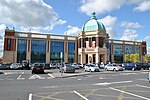
A design competition for the new building was assessed by John Ely, President of the Manchester Association of British Architects, and won by Charles Albert Hindle. [9] Construction started in 1899 although it was delayed while the builder removed an uncharted water cistern. [9] The new building was designed in the Jacobean style, built in red brick with stone dressings at a cost of £7,500 and officially opened in November 1901. [9] The original design (the central and right hand sections of the current building) involved an asymmetrical main frontage with five bays facing onto Market Street with the right hand bay featuring a Jacobean style gable containing a date stone; the central section of three bays, which slightly projected forward, featured a porch flanked by pilasters supporting an open pediment; there were mullioned windows on the first floor and an entablature carved with the name "Altrincham Town Hall" above. The building was extended to the south west by two extra bays in 1930 with the left hand end bay also featuring a Jacobean style gable containing a date stone so giving the building its current symmetry. [10]
Further population growth, in part driven by the construction and expansion of the facilities operated the Linotype and Machinery Company, [11] led to the area becoming a municipal borough with the town hall as its headquarters in 1937. [7] The town hall ceased to be the local seat of government when the enlarged Trafford Council was formed in 1974. [12] [13] An extensive programme of restoration works was completed in 2006, so enabling the building to serve as a venue for marriages and civil partnership ceremonies. [14] A statue depicting a market trader which had been sculpted by Colin Spofforth was unveiled outside the town hall by the Mayor of Trafford, Councillor Bernard Sharp, on 9 May 2008; [15] [16] a commemorative stone celebrating the Diamond Jubilee of Elizabeth II was erected there in spring 2012 [17] and, following a crowdfunding campaign, a six-foot aluminium silhouette of a First World War soldier was installed outside the town hall in November 2018. [18]
Works of art in the town hall include a painting by Tom Colley depicting troops loyal to the pretender to the throne, Charles Edward Stuart, seeking accommodation at The Red Lion Inn at Altrincham on 1 December 1745 during the Jacobite rising. [19]
Altrincham is a market town in Trafford, Greater Manchester, England, south of the River Mersey. It is 8 miles (13 km) southwest of Manchester, 3 miles (5 km) southwest of Sale and 10 miles (16 km) east of Warrington. At the 2011 census, it had a population of 52,419.
Trafford is a metropolitan borough of Greater Manchester, England, with an estimated population of 236,301 in 2022. It covers 106 square kilometres (41 sq mi) and includes the area of Old Trafford and the towns of Altrincham, Stretford, Urmston, Partington and Sale. The borough was formed in 1974 as a merger of six former districts and part of a seventh. The River Mersey flows through the borough, separating North Trafford from South Trafford, and the historic counties of Lancashire and Cheshire. Trafford is the seventh-most populous district in Greater Manchester.
Sale is a town in Trafford, Greater Manchester, England, in the historic county of Cheshire on the south bank of the River Mersey, 2 miles (3.2 km) south of Stretford, 3 miles (4.8 km) northeast of Altrincham, and 5 miles (8.0 km) southwest of Manchester. In 2021, it had a population of 54,515.
Timperley is a suburban village in the borough of Trafford, Greater Manchester, England. Within the boundaries of the historic county of Cheshire, it is approximately six miles southwest of central Manchester. The population at the 2011 census was 11,061.
Stretford is a market town in Trafford, Greater Manchester, England, sited on flat ground between the River Mersey and the Manchester Ship Canal; the Bridgewater Canal bisects the town. The town is located 4 miles (6.4 km) south of Manchester, 3 miles (4.8 km) south of Salford and 4 miles (6.4 km) north-east of Altrincham. Stretford borders Chorlton-cum-Hardy to the east, Moss Side and Whalley Range to the south-east, Hulme to the north-east, Urmston to the west, Salford to the north and Sale to the south.
Warburton is a village and civil parish in the Metropolitan Borough of Trafford, Greater Manchester, England. Historically in Cheshire, it lies on the south bank of the River Mersey. The village remains predominantly rural. Altrincham is the nearest town. At the 2001 census, the parish had a population of 286.
Dunham Massey is a civil parish in the Metropolitan Borough of Trafford, Greater Manchester, England. The parish includes the villages of Sinderland Green, Dunham Woodhouses and Dunham Town, along with Dunham Massey Hall and Park, formerly the home of the last Earl of Stamford and owned by the National Trust since 1976. Dunham Massey is in the historic county of Cheshire, but since 1974 has been part of Trafford Metropolitan Borough; the nearest town is Altrincham. At the 2001 census, the parish had a population of 475.
Bowdon is a suburb of Altrincham and electoral ward in the Metropolitan Borough of Trafford, Greater Manchester, England.
Dunham Town is a village in the civil parish of Dunham Massey in the Metropolitan Borough of Trafford, Greater Manchester, England. It was historically a part of Cheshire.
Broadheath is a town in Altrincham, Greater Manchester, England. Historically part of Cheshire, it had a population at the 2011 census of 12,538.
Altrincham Grammar School for Boys is a boys' grammar school in Altrincham, Greater Manchester, England.
Trafford Council, or Trafford Metropolitan Borough Council, is the local authority of the Metropolitan Borough of Trafford in Greater Manchester, England. It is a metropolitan borough council and provides the majority of local government services in the borough. The council has been a member of the Greater Manchester Combined Authority since 2011.
Dunham Massey Hall, usually known simply as Dunham Massey, is an English country house in the parish of Dunham Massey in the district of Trafford, near Altrincham, Greater Manchester. During World War I it was temporarily used as the Stamford Military Hospital.
Bowdon is an electoral ward of Trafford covering the Bowdon, Dunham Town and Dunham Massey areas of Altrincham, Greater Manchester, and the village of Warburton, Lymm.
Altrincham is a town in the Metropolitan Borough of Trafford, Greater Manchester, England. The town, together with the adjacent areas of Broadheath and Timperley, contains 52 listed buildings that are recorded in the National Heritage List for England. Of these, one is listed at Grade II*, the middle grade, and the others are at Grade II, the lowest grade.
Scarborough Town Hall, originally St Nicholas House, is a red brick Jacobean Revival mansion in Scarborough, North Yorkshire, England, currently used as a municipal building for the Borough of Scarborough and an events venue. It was built in the 19th century as a home for John Woodall, a prominent local businessman, and then converted and extended for municipal use in 1903. Situated overlooking the South Bay, it is a grade II listed building.
Sale Town Hall is a municipal building on School Road in Sale, Greater Manchester, England. The town hall was the headquarters of Sale Borough Council until the council was abolished in 1974.
Hyde Town Hall is a municipal building in the Market Street, Hyde, Greater Manchester, England. The town hall, which was the headquarters of Hyde Borough Council, is a grade II listed building.
Farnworth Town Hall is a municipal building in Market Street, Farnworth, Greater Manchester, England. The town hall, which was the headquarters of Farnworth Borough Council, is a grade II listed building.
The Old Town Hall is a municipal building in the High Street, Hemel Hempstead, Hertfordshire, England. The town hall, which was the meeting place of Hemel Hempstead Borough Council, is a Grade II listed building.