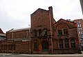
Salford Town Hall

Last updated

Salford Town Hall
Former Town Hall, Salford - geograph.org.uk - 1415163.jpg
Salford Town Hall
Location Salford
Coordinates 53°29′02″N2°15′32″W / 53.4838°N 2.259°W / 53.4838; -2.259
Built1827
Architect Richard Lane
Architectural style(s) Neo-classical style
Listed Building – Grade II
Designated31 January 1952
Reference no.1386076
Greater Manchester UK location map 2.svg
Red pog.svg
Shown in Greater Manchester

Salford Town Hall is the former town hall of Salford, Greater Manchester, England. It was the meeting place of the County Borough of Salford. Following the abolition of the county borough, it became Salford Magistrates' Court and continued to be used as such until 2011. The court was then merged with the court of Manchester to form the Manchester and Salford Magistrates' Court. The building is now in residential use and is a Grade II Listed Building being designated in January 1952. [1]

Contents

History

The foundation stone for the town hall was laid by Lord Bexley, Chancellor of the Duchy of Lancaster in April 1825. [2] The square in which the building now stands was named after him. [3] It was designed by Richard Lane in the Neo-classical style and completed in 1827. [1] The building, which was originally constructed as a market hall, [4] became the Salford's town hall in 1835 and, additionally, a courthouse in 1840. [4] The building was expanded three times in the nineteenth century. [4]

In January 1878 it was the place where local hero Mark Addy received several awards for his gallantry in saving people from drowning in the River Irwell. [5] On 1 October 1931 it was the scene of the 'Battle of Bexley Square' where 10,000 protesters of the Salford Branch of the National Unemployed Workers' Movement clashed with police, an event which is commemorated with a plaque on the building. [6] [7] The novelist Walter Greenwood was present at the demonstration and a similar event is portrayed in his novel "Love on the Dole". [8]

The building became the headquarters of the County Borough of Salford and continued to be called Salford Town Hall, notwithstanding that Salford was granted city status in 1926. [9] [10] It ceased to be the local seat of government when the county borough was abolished by the Local Government Act 1972 [11] and Swinton and Pendlebury Town Hall became the meeting place for the enlarged local authority area, known as the City of Salford, in 1974. [12]

Salford Town Hall was used as a court house until the last two court rooms closed in December 2011. [4] It was subsequently sold to private developers, who completed converting the building into apartments in November 2015. [13]

Architecture

The building was designed by Richard Lane, and was his first architectural project. Lane would go on to design several further prominent buildings in what is now Greater Manchester, including the Friends Meeting House in Chorlton-on-Medlock and Chorlton Town Hall, both of which have similar designs to Salford Town Hall. [6] The building is constructed in the style of the Neo-classical style, with a minimalist entablature of the Doric Order. Only the front of the building is faced with stone; the sides are red brick. [1]

See also

Related Research Articles

<span class="mw-page-title-main">Manchester</span> City and metropolitan borough in England

Manchester ( ) is a city and metropolitan borough in the county of Greater Manchester, England; it had a population of 552,000 at the 2021 census. It is bordered by the Cheshire Plain to the south, the Pennines to the north and east, and the neighbouring city of Salford to the west. The two cities and the surrounding towns form one of the United Kingdom's most populous conurbations, the Greater Manchester Built-up Area, which has a population of 2.87 million. The city borders the boroughs of Trafford, Stockport, Tameside, Oldham, Rochdale, Bury and Salford.

<span class="mw-page-title-main">Peterloo Massacre</span> 1819 killing by British troops in Manchester

The Peterloo Massacre took place at St Peter's Field, Manchester, Lancashire, England, on Monday 16 August 1819. Eighteen people died and 400–700 were injured when cavalry charged into a crowd of around 60,000 people who had gathered to demand the reform of parliamentary representation.

<span class="mw-page-title-main">Salford</span> City in Greater Manchester, England

Salford is a city in Greater Manchester, England. The city is situated in a meander on the western bank of the River Irwell which forms its boundary with Manchester and its city centre. Landmarks in the city include the 100 Greengate skyscraper, the old town hall, cathedral and St Philips Church. It is the main settlement of the wider City of Salford metropolitan borough.

<span class="mw-page-title-main">Chorlton-cum-Hardy</span> Human settlement in England

Chorlton-cum-Hardy is a suburban area of Manchester, England, three miles (4.8 km) southwest of the city centre. Chorlton ward had a population of 14,138 at the 2011 census, and Chorlton Park 15,147.

<span class="mw-page-title-main">Rochdale</span> Town in Greater Manchester, England

Rochdale is a town in Greater Manchester, England, and the administrative centre of the Metropolitan Borough of Rochdale. In the 2021 census the town had a population of 111,261, compared to 223,773 for the wider borough. Rochdale is in the foothills of the South Pennines and lies in the dale (valley) of the River Roch, 5 miles (8 km) northwest of Oldham and 10 miles (16 km) northeast of Manchester.

<span class="mw-page-title-main">Whitefield, Greater Manchester</span> Town in Greater Manchester, England

Whitefield is a town in the Metropolitan Borough of Bury, Greater Manchester, England. It lies on undulating ground above the Irwell Valley, along the south bank of the River Irwell, 3 miles (4.8 km) southeast of Bury, and 5 miles (8.0 km) northwest of Manchester. Prestwich and the M60 motorway lie just to the south.

<span class="mw-page-title-main">Salford Hundred</span>

The Salford Hundred was one of the subdivisions of the historic county of Lancashire in Northern England (see:Hundred. Its name alludes to its judicial centre being the township of Salford. It was also known as the Royal Manor of Salford and the Salford wapentake.

<span class="mw-page-title-main">Stretford</span> Town in Greater Manchester, England

Stretford is a market town in Trafford, Greater Manchester, England. It is situated on flat ground between the River Mersey and the Manchester Ship Canal, 3.8 miles (6.1 km) south of Manchester city centre, 3.0 miles (4.8 km) south of Salford and 4.2 miles (6.8 km) north-east of Altrincham. Stretford borders Chorlton-cum-Hardy to the east, Moss Side and Whalley Range to the south-east, Hulme to the north-east, Urmston to the west, Salford to the north, and Sale to the south. The Bridgewater Canal bisects the town.

<span class="mw-page-title-main">History of Manchester</span> Aspect of history

The history of Manchester encompasses its change from a minor Lancastrian township into the pre-eminent industrial metropolis of the United Kingdom and the world. Manchester began expanding "at an astonishing rate" around the turn of the 19th century as part of a process of unplanned urbanisation brought on by a boom in textile manufacture during the Industrial Revolution. The transformation took little more than a century.

<span class="mw-page-title-main">History of Lancashire</span> Aspect of history

Lancashire is a county of England, in the northwest of the country. The county did not exist in 1086, for the Domesday Book, and was apparently first created in 1182, making it one of the youngest of the traditional counties.

<span class="mw-page-title-main">Burnage</span> Human settlement in England

Burnage is an area of Manchester, England, 4 miles (6.4 km) south of the city centre and bisected by Kingsway. The population at the 2011 census was 15,227. It lies between Withington to the west, Levenshulme to the north, Heaton Chapel to the east and Didsbury and Heaton Mersey to the south.

<span class="mw-page-title-main">Pendlebury</span> Town in Greater Manchester, England

Pendlebury is a town in the City of Salford, Greater Manchester, England. The population at the 2011 Census was 13,069. It lies 4 miles (6.4 km) north-west of Manchester city centre, 3 miles (4.8 km) north-west of Salford and 6 miles (9.7 km) south-east of Bolton.

<span class="mw-page-title-main">Swinton, Greater Manchester</span> Town in Greater Manchester, England

Swinton is a town in the City of Salford in Greater Manchester, England. southwest of the River Irwell, 4 miles (6.4 km) northwest of Manchester, adjoining the town of Pendlebury and suburb of Clifton. In 2014, it had a population of 22,931.

<span class="mw-page-title-main">County Borough of Salford</span> Former district of England

Salford was, from 1844 to 1974, a local government district in the county of Lancashire in the northwest of England, covering the city of Salford. It was granted city status in 1926.

<span class="mw-page-title-main">Richard Lane (architect)</span> English architect

Richard Lane was an English architect of the early and mid-19th century. Born in London and based in Manchester, he was known mainly for his restrained and austere Greek-inspired classicism. He also designed a few buildings – mainly churches – in the Gothic style. He planned and designed many of the houses in the exclusive Victoria Park estate.

<span class="mw-page-title-main">Salford Civic Centre</span> Municipal building in Swinton, Greater Manchester, England

Salford Civic Centre, formerly Swinton and Pendlebury Town Hall, is a municipal building at Chorley Road, in Swinton, Greater Manchester, England. It is the administrative headquarters of Salford City Council.

<span class="mw-page-title-main">Bolton Town Hall</span> Municipal building in Bolton, Greater Manchester, England

Bolton Town Hall in Victoria Square, Bolton, Greater Manchester, England, was built between 1866 and 1873 for the County Borough of Bolton to designs by William Hill of Leeds and George Woodhouse of Bolton. The town hall was extended in the 1930s to the designs of Bradshaw, Gass and Hope and has been designated a Grade II* listed building by English Heritage.

<span class="mw-page-title-main">Ruth Frow</span> English peace activist and historian of the labour movement

Ruth Frow was a peace activist and historian of the labour movement. She co-founded the Working Class Movement Library in Salford, a collection of material associated with labour and working class history.

<span class="mw-page-title-main">Old Town Hall, Wolverhampton</span> Municipal building in Wolverhampton, West Midlands, England

The old Town Hall is a former municipal facility in North Street, Wolverhampton, West Midlands, United Kingdom. It is a Grade II listed building.

<span class="mw-page-title-main">Lancaster Town Hall</span> Municipal building in Lancaster, Lancashire, England

Lancaster Town Hall is a municipal building in Dalton Square, Lancaster, Lancashire, England. It was built in 1909 and is a Grade II* listed building.

References

  1. 1 2 3 Historic England. "Salford Town Hall (1386076)". National Heritage List for England . Retrieved 8 February 2019.
  2. Farrer, William; Brownbill, J. (1911). "'Townships: Salford', in A History of the County of Lancaster". London: British History Online. pp. 204–217. Retrieved 8 August 2020.
  3. Hindle, Paul (2019). Salford History Tour. Amberley Publishing. ISBN   978-1445693781.
  4. 1 2 3 4 Britton, Paul (9 December 2013). "Former town hall and court to be turned into apartments". Manchester Evening News. Retrieved 22 April 2020.
  5. Lancashire Life: A Salford Hero, April 1988
  6. 1 2 "Salford Town Hall". Manchester History. Retrieved 22 April 2020.
  7. "The Battle of Bexley Square: Salford Unemployed Workers' Demonstration". Lib.com. 1 October 1931. Retrieved 8 August 2020.
  8. Frow, Edmund; Frow, Ruth (13 December 2009). "The Battle of Bexley Square". libcom.org. Retrieved 1 October 2021.
  9. Beckett, J V (2005). City status in the British Isles, 1830–2002. Historical urban studies. Aldershot: Ashgate. ISBN   0-7546-5067-7.
  10. "No. 33154". The London Gazette . 23 April 1926. pp. 2776–2777.
  11. "Local Government Act 1972". Legislation.gov.uk. Retrieved 22 April 2020.
  12. "Civic Centre history". Salford City Council. Retrieved 22 April 2020.
  13. "Salford Town Hall". Bardsley. Retrieved 22 April 2020.