
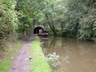
Disley is a village and civil parish in Cheshire, England, on the edge of the Peak District in the Goyt valley south of Stockport, close to the county boundary with Derbyshire at New Mills. The population at the 2011 Census was 4,294. To the north, the River Goyt and the Peak Forest Canal, which opened in 1800, pass along the edge of the village. Today it is a dormitory village retaining a semi-rural character.

Stockport is a large town in Greater Manchester, England, 7 miles (11 km) south-east of Manchester city centre, where the rivers Goyt and Tame merge to create the River Mersey. It is the largest town in the metropolitan borough of the same name.
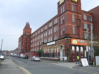
Reddish is an area in Metropolitan Borough of Stockport, Greater Manchester, England. 4.6 miles (7.4 km) south-east of Manchester city centre. At the 2011 Census, the population was 28,052. Historically part of Lancashire, Reddish grew rapidly in the Industrial Revolution and still retains landmarks from that period, such as Houldsworth Mill, a former textile mill.

Compstall is a village in the Metropolitan Borough of Stockport, Greater Manchester, England; it is situated between Marple Bridge and Romiley and is historically part of Cheshire. It was formerly a mill village, built by George Andrew in the 1820s to house his 800 workers. Most of the original mill cottages and other structures remain unchanged.
Woodley is a suburb in the Metropolitan Borough of Stockport, Greater Manchester, England, on the east side of the Peak Forest Canal, next to Bredbury and Romiley and the boundary with Gee Cross, Tameside.

Romiley is a village in the Metropolitan Borough of Stockport, Greater Manchester, England. Historically part of Cheshire, it borders Marple, Bredbury and Woodley. At the 2011 census, the Romiley ward, which includes Compstall, Bredbury Green and a large part of Bredbury, had a population of 14,139.

Hazel Grove is a constituency in Greater Manchester, England represented in the House of Commons of the UK Parliament since 2015 by William Wragg, a Conservative.

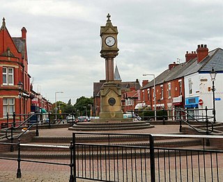
Bredbury is a town in the Metropolitan Borough of Stockport, Greater Manchester, England, 7.9 miles (12.7 km) south-east of Manchester, 1.8 miles (2.9 km) east of Stockport and 3.2 miles (5.1 km) south-west of Hyde. At the 2011 census, it had a population of 16,721.
The Metropolitan Borough of Stockport is a metropolitan borough of Greater Manchester in North West England, south-east of central Manchester. As well as the towns of Stockport, Bredbury and Marple, it includes the outlying areas of Hazel Grove, Bramhall, Cheadle, Cheadle Hulme Gatley, Reddish, Woodley and Romiley. In 2001, it had a population of 284,500.

Marple Bridge is a district of Marple in the Metropolitan Borough of Stockport, Greater Manchester, England, on the River Goyt, which runs through the centre of the village, close to Marple.

Rose Hill Marple railway station is in Marple in the Metropolitan Borough of Stockport, England. The station, which opened in 1869, is the last surviving stop on the former Macclesfield, Bollington and Marple Railway ("MB&MR"). It is connected via a short branch to the Hope Valley Line. The original line to Macclesfield closed in January 1970, leaving Rose Hill Marple as the terminus of the route. Daily services run to Manchester Piccadilly, except on Sundays.

Bredbury and Romiley was an urban district in the administrative county of Cheshire, England from 1894 to 1974, which covered the civil parishes of Bredbury, Compstall and Romiley.

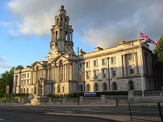
Stockport County Borough was created by the Municipal Corporations Act 1835 when the existing Borough of Stockport was reformed as a municipal borough. Until 1835 the town was governed by a charter dating from circa 1220 granted by Ranulph de Blondeville, 4th Earl of Chester. The municipal borough consisted of parts of Cheshire, namely the township of Stockport and the neighbouring areas of Edgeley and Portwood and part of Heaton Norris in Lancashire.
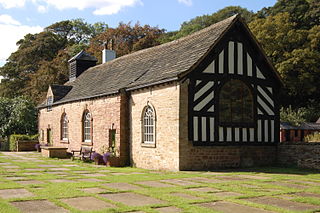
Chadkirk Chapel is a restored historic chapel near Romiley in the Metropolitan Borough of Stockport in Greater Manchester, England. It is recorded in the National Heritage List for England as a designated Grade II* listed building.
Vernon Mill, Stockport is a former cotton spinning mill in Portwood, Stockport, Greater Manchester, England. Built in 1881, it was taken over by the Lancashire Cotton Corporation in 1930 and later sold on. Although still in business use, it is now a grade II listed building.
Welkin Mill, Lower Bredbury is a cotton spinning mill in Lower Bredbury/Portwood, Stockport, Greater Manchester. It was built in the early years of the 20th century for ring spinning. It was taken over by the Lancashire Cotton Corporation in the 1930s and passed to Courtaulds in 1964. Production ended in 1967. The 162,000 sq ft (15,100 m2), four-storey mill occupies a 5.15 acres (2.08 ha) site on Welkin Road.

Elder Mill, Romiley was a cotton spinning mill in Romiley, Stockport, Greater Manchester. It was taken over by the Lancashire Cotton Corporation in the 1930s and passed to Courtaulds in 1964.
Vernon Park is the oldest country park in Stockport, Greater Manchester, England. The Victorian park contains the Vernon Park Museum.

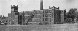
Pear New Mill is a former Edwardian cotton spinning mill on the northern bank of the River Goyt in Bredbury, Stockport, Greater Manchester, England. It is a Grade II* listed building.
Bredbury and Romiley are towns in the Metropolitan Borough of Stockport, Greater Manchester, England. The towns, together with the area of Woodley and the village of Compstall and the surrounding countryside, contain 43 listed buildings that are recorded in the National Heritage List for England. Of these, two are listed at Grade II*, the middle grade, and the others are at Grade II, the lowest grade.

