
The River Etherow is a river in northern England, and a tributary of the River Goyt. Although now passing through South Yorkshire, Derbyshire and Greater Manchester, it historically formed the ancient county boundary between Cheshire and Derbyshire. The upper valley is known as Longdendale. The river has a watershed of approximately 30 square miles (78 km2), and the area an annual rainfall of 52.5 inches (1,330 mm).

The River Roch is a river in Greater Manchester in North West England, a tributary of the River Irwell, that gives Rochdale its name.
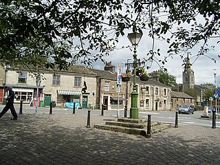
Littleborough is a town within the Metropolitan Borough of Rochdale, in Greater Manchester, England. It is located in the upper Roch Valley by the foothills of the South Pennines, 3 miles (4.8 km) northeast of Rochdale and 12.6 miles (20.3 km) north-northeast of Manchester; Milnrow and the M62 motorway are to the south, and the rural uplands of Blackstone Edge are to the east. In 2001, Littleborough and its suburbs of Calderbrook, Shore and Smithy Bridge, had a population of 13,807.

Hollingworth Lake is a 130-acre (53 ha) reservoir at Smithy Bridge in Littleborough, Greater Manchester, England. It was originally built as the main water source for the Rochdale Canal, but developed as a tourist resort from the 1860s. Hotels were built around it, helped by the arrival of the railway in 1839, which brought day-trippers and weekend visitors from Manchester, Bradford and Leeds.
The River Sett is a river that flows through the High Peak borough of Derbyshire, in north western England. It rises near Edale Cross on Kinder Scout and flows through the villages of Hayfield and Birch Vale to join the River Goyt at New Mills. The River Goyt is one of the principal tributaries of the River Mersey. In the past, the river was known as the River Kinder; the modern River Kinder is a right tributary of the Sett, joining the river at Bowden Bridge above Hayfield.

Blackstone Edge is a gritstone escarpment at 1,549 feet above sea level in the Pennine hills surrounded by moorland on the boundary between Greater Manchester and West Yorkshire in England.
Hollingworth may refer to:

Arnfield Reservoir is a man-made lake in Longdendale in north Derbyshire. It was constructed in 1854 as part of the Longdendale chain to supply water from the River Etherow to the urban areas of Greater Manchester. Unlike the other reservoirs in the chain, Arnfield and Hollingworth Reservoir are not in the Etherow valley but lie in the valley of tributary brooks to the north and above. From Arnfield the water is extracted to pass through the Mottram Tunnel to Godley.

The A628 is a major road connecting Greater Manchester and South Yorkshire in northern England. It crosses the Pennine hills by way of Longdendale and the Woodhead Pass in the Peak District National Park. The road's altitude and exposure to bad weather create problems in winter and the road is sometimes closed due to snow or high winds.

Butterworth was a township occupying the southeastern part of the parish of Rochdale, in the hundred of Salford, Lancashire, England. It encompassed 12.1 square miles (31 km2) of land in the South Pennines which spanned the settlements of Belfield, Bleaked-gate-cum-Roughbank, Butterworth Hall, Clegg, Haughs, Hollingworth, Kitcliffe, Lowhouse, Milnrow, Newhey, Ogden, Rakewood, Smithy Bridge, Tunshill and Wildhouse. It extended to the borders of Crompton to the south, and to the highest points of Bleakedgate Moor and Clegg Moor, up to the ridge of Blackstone Edge, to the east, where its boundary was the old county boundary between Lancashire and Yorkshire.

Piethorne Brook is a watercourse in Greater Manchester. It is a tributary of the River Beal.

Smithy Bridge is a suburb of Littleborough in the Metropolitan Borough of Rochdale, Greater Manchester, England. Hollingworth Lake Country Park is close by. It also has a link to the Rochdale Canal and has its own railway station. It was once a route on the packhorse trip through to Yorkshire.

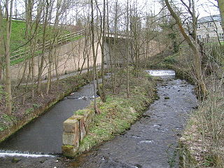
Hollingworth Brook is a water course in Greater Manchester which originates at Hollingworth Lake and flows through the Ealees Valley where it merges with Shore Lane Brook to form Ealees Brook.

Rochdale Interchange is a transport hub located in the town of Rochdale in Greater Manchester, England, run by Transport for Greater Manchester.
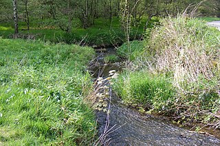
Shore Lane Brook is a water course in Greater Manchester and a tributary of Ealees Brook in Littleborough.
Hollingworth Academy is a coeducational secondary school with academy status located in Milnrow in the English county of Greater Manchester.
Littleborough is a town in the Metropolitan Borough of Rochdale, Greater Manchester, England, and it is unparished. The town, its suburbs of Calderbrook and Smithy Bridge, and the surrounding countryside contain 79 listed buildings that are recorded in the National Heritage List for England. Of these, five are listed at Grade II*, the middle grade, and the others are at Grade II, the lowest grade. The area is largely rural, and most of the listed buildings are houses and associated structures, farmhouses, and farm buildings. Following the Industrial Revolution textile mills were built, some of which remain and are listed. The Rochdale Canal passes through the area and bridges and locks associated with it are listed. Also passing through the area was the Manchester and Leeds Railway, and structures associated with it are listed. The other listed buildings include churches, public houses, a former toll house, a bandstand, a drinking fountain, and two war memorials.
Hollingworth Lake Rowing Club is a rowing club on Hollingworth Lake and based at The Clubhouse, Lake Bank, Littleborough, Greater Manchester. The club was founded in 1872 but the current clubhouse was built in 1972.
