St. Felix is a municipality that holds community status in Prince Edward Island, Canada. It is located in Prince County, 4 km (2.5 mi) south of Tignish.

The River Spodden is a watercourse in North West England, one of two major tributaries of the River Roch. It rises in the Lancashire South Pennine hills north of Whitworth and flows south through what is now known as the Whitworth Valley to Rochdale, Greater Manchester, where the river merges with the River Roch. Nestled within the picturesque wooded valley is Healey Dell Nature Reserve.

The Beal is a small river in Greater Manchester, England, and is a tributary of the River Roch. It rises in the Beal Valley in green space between Sholver and Royton, before continuing northwards through Shaw and Crompton, Newhey, Milnrow and Belfield.

Naden Brook is a watercourse in north west England. It rises in the hills above Norden, near the boundary of Lancashire and Greater Manchester. From here it flows south to Heywood, where it merges with the River Roch.
Wrigley Brook is a culverted watercourse in Greater Manchester which flows through Heywood and is a tributary of the River Roch. Originating in the Hareshill area to the South of Heywood, it flows northwards and joins the River Roch at Bottom O' th' Brow.

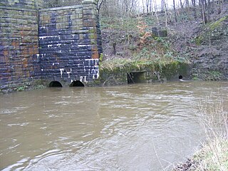
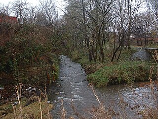
Ealees Brook is a water course in Greater Manchester named after the Ealees area of Littleborough. It flows northwards from the Ealees Valley to the River Roch in Littleborough.

Stanney Brook is a watercourse in Greater Manchester, England. It originates in the Burnedge area of Shaw and Crompton, and flows through Milnrow into Rochdale before joining the River Roch at Newbold Brow. Alone among the watercourses of Milnrow and Newhey, it does not pass through the centre of either village, and flows directly into the River Roch, rather than first into the River Beal. Its name derives from the Lancashire dialect word "stanner", a ridge of stones. It is also unusual in that the borough in which it rises, changes, depending on the wetness of surrounding moorland. The brook drops 100 metres in a little over 5.5 kilometres, or 330feet in 3.5 miles. It is culverted four times, generally is only 60 cm(3 ft) wide, and rarely exceeds 90 cm(3 ft) in width at any point.
Hey Brook is a watercourse in Rochdale, Greater Manchester and a tributary of the River Roch. It originates at the confluence of Buckley Brook and Syke Brook, and flows through Wardleworth to the River Roch.
Moss Brook is a watercourse in Rochdale, Greater Manchester and a tributary of the River Roch. It originates in Newbold, and flows Northwards to join the River Roch. The majority of the brook is now culverted.

Sudden Brook is a watercourse in Greater Manchester and a tributary of the River Roch. It originates in to the north of Royton, Oldham and flows Northwards through Kirkholt and Sandbrook Park to join the River Roch at Sudden.
Parr Brook is a watercourse in Greater Manchester and a tributary of the River Roch. It originates in Unsworth and flows through Bury Golf Club before joining the River Roch at Blackford Bridge.
Ash Brook is a watercourse in Greater Manchester and a tributary of the River Roch.
Featherstall Brook is a watercourse in Greater Manchester and a tributary of the River Roch.
Town House Brook is a watercourse in Greater Manchester and a tributary of the River Roch.
Greenvale Brook is a watercourse in Greater Manchester and a tributary of the River Roch.
Hollins Brook is a watercourse in Greater Manchester and a tributary of the River Roch.
Tack Lee Brook is a watercourse in Greater Manchester and a tributary of the River Roch.
The Little Saint Roch River is a river in Quebec and Maine. From its source, in L'Islet RCM, the river runs south and southeast across the Canada–United States border to the Shields Branch of the Big Black River in Maine Township 15, Range 15, WELS.
The Shields Branch is a tributary of the Big Black River), flowing in:
This page is based on this
Wikipedia article Text is available under the
CC BY-SA 4.0 license; additional terms may apply.
Images, videos and audio are available under their respective licenses.


