Rock climbing is a popular activity in the Peak District; particularly on edges such as Stanage or Froggatt. Generally the climbing style is free climbing and the rock is either gritstone or limestone. Climbing has been practised in the Peak District since the late 19th century; James W. Puttrell is generally credited with starting the sport. The first climbing guidebook to the area was Some Gritstone Climbs, by John Laycock, published in 1913. There are over 10,000 routes in the Peak District. One of the most famous Peak District climbers, and a pioneer of many new routes, is Ron Fawcett. The climb known as "Master's Edge", on Millstone Edge, near Hathersage, is a testament to his skill and strength. The climb is graded E7 6c and rises 19m up the near vertical edge.

The River Tame flows through Greater Manchester, England. It rises on Denshaw Moor and flows to Stockport where it joins the River Goyt to form the River Mersey.

Greenfield is a village in the Saddleworth parish of the Metropolitan Borough of Oldham, England. It is 4 miles (6.4 km) east of Oldham, and 13 miles (21 km) east-northeast of the city of Manchester. It lies in a broad rural area in the southern edge of the South Pennines. To the east of the village Dovestone Reservoir, Chew Reservoir and Greenfield Reservoir lie within the Peak District National Park, though no part of the village itself lies within the Peak Park boundary.
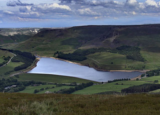
Dovestone Reservoir lies at the convergence of the valleys of the Greenfield and Chew Brooks above the village of Greenfield, on Saddleworth Moor in Greater Manchester, England. The reservoir is on the western edge of the Peak District National Park. It supplies drinking water to the surrounding area and is a tourist attraction, providing several walks amongst picturesque landscapes.

Colne Valley is a constituency represented in the House of Commons of the UK Parliament since 2019 by Jason McCartney of the Conservative Party.

Greenfield railway station in the village of Greenfield, Greater Manchester, England, is on the Huddersfield Line 12 miles (20 km) northeast of Manchester Victoria. It is the final station in Greater Manchester before the West Yorkshire boundary.

The A635 is a main road that runs between Manchester and Scawsby running east–west through Stalybridge, Saddleworth Moor, Holmfirth, Barnsley and Doncaster. The section forming the eastern part of the Mancunian Way is in fact a motorway and is officially designated as the A635(M) though there is no road sign with this designation; indeed the signs at the entrance of Mancunian Way westbound show A57(M).

Saddleworth Moor is a moorland in North West England. Reaching more than 1,312 feet (400 m) above sea level, it is in the Dark Peak area of the Peak District National Park. It is crossed by the A635 road and the Pennine Way passes to its eastern side.
Chew Reservoir is a reservoir at the head of the Chew Valley in the Peak District National Park in Greater Manchester, England.

Black Chew Head in Saddleworth in the Metropolitan Borough of Oldham is the highest point or county top of Greater Manchester in northern England. It stands on moorland on the edge of the Peak District at a height of 542 metres (1,778 ft) above sea level, close to the border with the High Peak district of Derbyshire.
The Holmfirth floods refers to a number of instances when severe flooding had occurred in the Holme Valley, West Yorkshire, England affecting Holmfirth and other settlements in the valley. The earliest record dates from 1738 and the latest from 1944. The most severe flood occurred early on the morning of 5 February 1852, when the embankment of the Bilberry reservoir collapsed causing the deaths of 81 people. It is recorded as the 23rd most serious, worldwide, in terms of loss of life from floods and landslides in human history.

The South Pennines is a region of moorland and hill country in northern England lying towards the southern end of the Pennines. In the west it includes the Rossendale Valley and the West Pennine Moors. It is bounded by the Greater Manchester conurbation in the west and the Bowland Fells and Yorkshire Dales to the north. To the east it is fringed by the towns of West Yorkshire whilst to the south it is bounded by the Peak District. The rural South Pennine Moors constitutes both a Site of Special Scientific Interest and Special Area of Conservation.
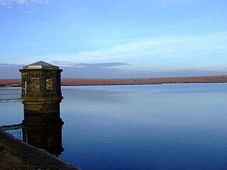
Yeoman Hey Reservoir is a reservoir in the English Peak District. On its margin is a commemorative stone laid by the King of Tonga in 1981. The reservoir is within the boundaries of Greater Manchester but was formerly in the West Riding of Yorkshire. It is one of three reservoirs in the same valley: above it is Greenfield Reservoir, and adjacent to and below it is Dovestone Reservoir. The reservoirs lie to the south of the A635 road across Saddleworth Moor. To the west, below the reservoirs, is the village of Greenfield.
Friezland Railway Station served the Hamlet of Friezland in Saddleworth until closure on 1 January 1917. It was built by the London and North Western Railway on its Micklehurst Line.

Denshaw is a village in Saddleworth—a civil parish of the Metropolitan Borough of Oldham, in Greater Manchester, England. It lies by the source of the River Tame, high amongst the Pennines above the village of Delph, 4.6 miles (7.4 km) northeast of Oldham,3.3 miles (5.3 km) north-northwest of Uppermill and Shaw and Crompton. It has a population of around 500.

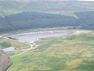
Greenfield Reservoir is a reservoir in the Saddleworth parish of the Metropolitan Borough of Oldham in Greater Manchester, in the English Peak District. Lying within the historic boundaries of the West Riding of Yorkshire, above the village of Greenfield, it is on the edge of the Peak District National Park, near the A635 road on Saddleworth Moor. The reservoir is fed by the Greenfield Brook and is above the Yeoman Hey Reservoir, which in turn feeds into Dovestone Reservoir.
David Lytton, formerly known as David Keith Lautenberg and after the discovery of his body by the placeholder name Neil Dovestone, was a previously unidentified British man found dead on Saddleworth Moor, in the South Pennines of Northern England on 12 December 2015. The placeholder name was reportedly devised by mortuary attendants at Royal Oldham Hospital, with reference to the location the body was found near Dovestone Reservoir, on an asphalt track in the Chew Valley.

The Peak District Boundary Walk is a circular 190-mile (310 km) walking trail, starting and finishing at Buxton and broadly following the boundary of the Peak District, Britain's first national park. The route was developed by the Friends of the Peak District and was launched on 17 June 2017.

Greenfield Valley is a river valley through Saddleworth Moor in England's Peak District National Park. Historically this area of the South Pennines was part of Yorkshire but since 1974 it has been within the eastern edge of the county of Greater Manchester.


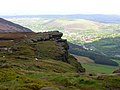 Wimberry Rocks in the Chew Valley
 Sign showing ownership of the valley by United Utilities and old maps of the tram that once ran through the valley
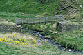 Oldham Way footpath, Chew Valley

