
Saddleworth is a civil parish of the Metropolitan Borough of Oldham in Greater Manchester, England. It comprises several villages and hamlets as well as suburbs of Oldham on the west side of the Pennine hills.

The Metropolitan Borough of Oldham is a metropolitan borough of Greater Manchester in England. It is named after its largest town, Oldham. The borough had a population of 242,072 in 2021, making it the sixth-largest district by population in Greater Manchester. The borough spans 142.3 square kilometres (54.9 sq mi).
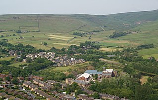
Greenfield is a village in the civil parish of Saddleworth in the Metropolitan Borough of Oldham, in Greater Manchester, England. It is 4 miles (6.4 km) east of Oldham and 13 miles (21 km) north-east of Manchester. It is located in a broad rural area at the southern edge of the South Pennines; Dovestone Reservoir, Chew Reservoir and Greenfield Reservoir lie to the east of the village in the Peak District National Park.
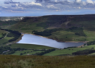
Dove Stone Reservoir lies at the convergence of the valleys of the Greenfield and Chew Brooks above the village of Greenfield, on Saddleworth Moor in Greater Manchester, England. The reservoir is on the western edge of the Peak District National Park. It supplies drinking water to the surrounding area and is a tourist attraction, providing several walks amongst picturesque landscapes.

Greenfield railway station in the village of Greenfield, Greater Manchester, England, is on the Huddersfield Line 12 miles (20 km) northeast of Manchester Victoria. It is the final station in Greater Manchester before the West Yorkshire boundary. It is operated by Northern Trains although only TransPennine Express trains call at this station.

The A635 is a main road that runs between Manchester and Doncaster running east–west through Stalybridge, Saddleworth Moor, Holmfirth, Barnsley and the Dearne Valley. The section forming the eastern part of the Mancunian Way is a motorway and is officially designated as the A635(M) though there is no road sign with this designation, and the signs at the entrance of Mancunian Way westbound show A57(M).

Saddleworth Moor is a moorland in North West England. Reaching more than 1,312 feet (400 m) above sea level, it is in the Dark Peak area of the Peak District National Park. It is crossed by the A635 road and the Pennine Way passes to its eastern side.
Diggle is a village in the civil parish of the Saddleworth in Metropolitan Borough of Oldham, in Greater Manchester, England. The village is situated on the moorlands of the Pennine hills.

Chew Valley in Saddleworth, Greater Manchester, England, follows the course of Chew Brook on the western slopes of Black Chew Head to where it joins the River Tame at Greenfield, east of Manchester. Part of the higher fringes of the valley towards the peak of Black Chew Head lie across the boundary in Derbyshire. The eastern part of the valley including the reservoirs of Dovestone and Chew are within the north western extremity of the Peak District National Park.
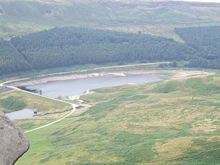
Chew Reservoir is a reservoir at the head of the Chew Valley in the Peak District National Park in Greater Manchester, England.

The Longdendale Chain is a sequence of six reservoirs on the River Etherow in the Longdendale Valley, in northern Derbyshire. They were constructed between 1848 and 1884 to a design by John Frederick Bateman to supply the growing population of Manchester and Salford with fresh water.

Lamaload Reservoir is a reservoir near Rainow, Cheshire, England. It lies in the South West Peak within the Peak District National Park, to the west of the Goyt Valley, and is fed by the River Dean. The reservoir is 0.93 km × 0.53 km, with a capacity of 1,909,000 m³, impounded by a multiple-arch, round-headed buttress dam in concrete, whose design was innovative at the time. It was built by Richard Costain Ltd in 1959–63 to serve Macclesfield, which lies to its west, and officially opened in 1965. The reservoir and associated water treatment works are owned by United Utilities. The area is a popular tourist spot, forming an access point for walkers to the surrounding moorland.

Black Chew Head in Saddleworth in the Metropolitan Borough of Oldham is the highest point or county top of Greater Manchester in northern England. It stands on moorland on the edge of the Peak District at a height of 542 m (1,778 ft) above sea level, close to the border with the High Peak district of Derbyshire.
Castleshaw is a hamlet in the Saddleworth parish of the Metropolitan Borough of Oldham in Greater Manchester, England. It lies amid the Pennines, 2.4 miles (3.9 km) north of Uppermill, 3 miles (4.8 km) west-southwest of Marsden, and 5.3 miles (8.5 km) east-northeast of Oldham.
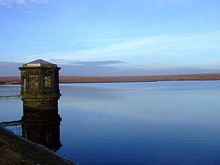
Yeoman Hey Reservoir is a reservoir in the English Peak District. On its margin is a commemorative stone laid by the King of Tonga in 1981. The reservoir is within the boundaries of Greater Manchester but was formerly in the West Riding of Yorkshire. It is one of three reservoirs in the same valley: above it is Greenfield Reservoir, and adjacent to and below it is Dovestone Reservoir. The reservoirs lie to the south of the A635 road across Saddleworth Moor. To the west, below the reservoirs, is the village of Greenfield.

Denshaw is a village in the civil parish of Saddleworth in the Metropolitan Borough of Oldham, in Greater Manchester, England. It lies by the source of the River Tame, high amongst the Pennines above the village of Delph, 4.6 miles (7.4 km) northeast of Oldham,3.3 miles (5.3 km) north-northwest of Uppermill and Shaw and Crompton. It has a population of around 500.
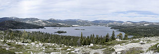
The Upper American River Project (UARP) is a hydroelectric system operated by the Sacramento Municipal Utility District (SMUD) of Sacramento, California in the United States.
For the reservoirs near Glossop, in Derbyshire, see Upper Swineshaw Reservoir and Swineshaw Reservoir (Derbyshire)

Greenfield Valley is a river valley through Saddleworth Moor in England's Peak District National Park. Historically this area of the South Pennines was part of Yorkshire but since 1974 it has been within the eastern edge of the county of Greater Manchester.

