
The Pennine Way is a National Trail in England, with a small section in Scotland. The trail stretches for 268 miles (431 km) from Edale, in the northern Derbyshire Peak District, north through the Yorkshire Dales and Northumberland National Park and ends at Kirk Yetholm, just inside the Scottish border. The path runs along the Pennine hills, sometimes described as the "backbone of England". Although not the United Kingdom's longest National Trail, it is, according to The Ramblers, "one of Britain's best known and toughest".

Kielder Forest is a large forestry plantation in Northumberland, England, surrounding Kielder village and the Kielder Water reservoir. It is the largest man-made woodland in England with three-quarters of its 250 square miles (650 km2) covered by forest. The majority of the forest lies within Kielder Water and Forest Park, with the southern tip known as Wark Forest lying within Northumberland National Park. The forest is next to the Anglo-Scottish border.

The Southern Uplands are the southernmost and least populous of mainland Scotland's three major geographic areas. The term is used both to describe the geographical region and to collectively denote the various ranges of hills and mountains within this region. An overwhelmingly rural and agricultural region, the Southern Uplands are partly forested and contain many areas of open moorland - the hill names in the area are congruent with these characteristics.

Butteryhaugh is a village in Northumberland, England. It lies 0.5 km to the south-east of Kielder.

Redesdale is a valley in western Northumberland, England. It is formed by the River Rede, which rises in the Cheviots and flows down to join the North Tyne at Redesmouth. Redesdale is traversed by the A68 trunk road, which enters Scotland via Carter Bar at the head of the valley.

Scar House Reservoir is the second of the three reservoirs in Upper Nidderdale, North Yorkshire, England, the others are Angram Reservoir and Gouthwaite Reservoir. Between them they attract around 150,000 visitors a year.
Carter Bar is a pass in the Cheviot Hills, on the Anglo-Scottish border. It lies north east of Carter Fell at the head of Redesdale, and is crossed by the A68 road as it runs north towards Jedburgh and Teviotdale.

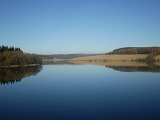
Kielder is a small, remote village in western Northumberland, England. Located at the head of Kielder Water and in the north west of Kielder Forest, the village is within three miles of the Scottish border.

The Rede is a river in Northumberland, England. The river rises on Carter Fell on the Anglo-Scottish border feeding Catcleugh Reservoir and joins the River North Tyne below the village of Redesmouth. The Rede is one of only two rivers in the North East of England that has the freshwater pearl mussel in its waters.

The Anglo-Scottish border is an internal border of the United Kingdom separating Scotland and England which runs for 96 miles (154 km) between Marshall Meadows Bay on the east coast and the Solway Firth in the west.

Peel Fell is the highest hill in the Kielder Forest region of England, making it the highest hill for several miles in each direction until the Cheviot Hills to the north-east are reached. Because of this, it has enough relative height to make it a Marilyn. It lies in both the county of Northumberland and the county of Roxburghshire, which is now governed by the Scottish Borders council, as the summit is on the border with Scotland.

Barrowburn is a hamlet in Upper Coquetdale in the county of Northumberland, England. It comprises a working farm with associated buildings and two holiday lets. One of the holiday lets is the Old School House, which closed as a school in the 1970s. The settlement is situated by the River Coquet, at its confluence with Barrow Burn (stream), after which the settlement is named. There is a road bridge over the Coquet and a ford over the burn here.

Rochester is a small village and civil parish in north Northumberland, England. It is 5 miles (8 km) north-west of Otterburn on the A68 road between Corbridge and Jedburgh. The village is the site of the Roman fort of Bremenium, built there to protect the important Roman road of Dere Street, which passes through the village.
Northumbrian Water Limited is a water company in the United Kingdom, providing mains water and sewerage services in the English counties of Northumberland, Tyne and Wear, Durham and parts of North Yorkshire, and also supplying water as Essex and Suffolk Water. It is a wholly owned subsidiary of Northumbrian Water Group.

The Cheviot Hills, or sometimes The Cheviots, are a range of uplands straddling the Anglo-Scottish border between Northumberland and the Scottish Borders. The English section is within the Northumberland National Park. The range includes The Cheviot, plus Hedgehope Hill to the east, Windy Gyle to the west, and Cushat Law and Bloodybush Edge to the south.
Easington is a civil parish within the Ribble Valley district of Lancashire, England, with a population in 2001 of 52. The Census 2011 population details have been grouped with the parish of Slaidburn. Before 1974, it formed part of Bowland Rural District in the West Riding of Yorkshire. It covers just over 9000 acres.
The geology of Northumberland in northeast England includes a mix of sedimentary, intrusive and extrusive igneous rocks from the Palaeozoic and Cenozoic eras. Devonian age volcanic rocks and a granite pluton form the Cheviot massif. The geology of the rest of the county is characterised largely by a thick sequence of sedimentary rocks of Carboniferous age. These are intruded by both Permian and Palaeogene dykes and sills and the whole is overlain by unconsolidated sediments from the last ice age and the post-glacial period. The Whin Sill makes a significant impact on Northumberland's character and the former working of the Northumberland Coalfield significantly influenced the development of the county's economy. The county's geology contributes to a series of significant landscape features around which the Northumberland National Park was designated.
The geology of Northumberland National Park in northeast England includes a mix of sedimentary, intrusive and extrusive igneous rocks from the Palaeozoic and Cenozoic eras. Devonian age volcanic rocks and a granite pluton form the Cheviot massif. The geology of the rest of the national park is characterised largely by a thick sequence of sedimentary rocks of Carboniferous age. These are intruded by Permian dykes and sills, of which the Whin Sill makes a significant impact in the south of the park. Further dykes were intruded during the Palaeogene period. The whole is overlain by unconsolidated sediments from the last ice age and the post-glacial period.
Border Moors and Forests NCA is an upland plateau region in Northern England between the North East and North West regions, and touching the Anglo-Scottish border. The region, like much of the northern English uplands, is sparsely populated, with scattered farming and hardy shepherding in river valleys. Because of this sparse population, 39% of the region is part of the Northumberland National Park in the southeast and several military assets are placed here, both modern and ancient. The NCA is of lower elevation to the Cheviot Hills to the east. The A68 is the only main road going through the region. Conifer plantations, moorland, bogs, wet heaths make up the landscape of the region, which only allows for rough grazing of sheep in most areas outside of the valleys. Afforestation is a major environmental factor within the 20th and 21st centuries, as the Kielder Forest is the largest planted forest in northern Europe and has destroyed many native mires and peat bogs of the region. As such in the 21st century preserving the moors has been a top priority in the region as its habitat is home to high biodiversity and the region also serves as an important storer of carbon in its moors.

