Middleton-by-Wirksworth

Last updated

Middleton
Middleton-by-Wirksworth 426707 a54ca84e.jpg
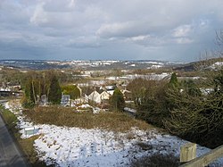
View of the eastern end of Middleton village, from the High Peak Trail
Derbyshire UK location map.svg
Red pog.svg
Middleton
Location within Derbyshire
Population775 (2011)
OS grid reference SK277559
Civil parish
  • Middleton
District
Shire county
Region
Country England
Sovereign state United Kingdom
Post town MATLOCK
Postcode district DE4 4
Dialling code 01629
Police Derbyshire
Fire Derbyshire
Ambulance East Midlands
UK Parliament
List of places
UK
England
Derbyshire
53°06′03″N1°35′19″W / 53.1009°N 1.5885°W / 53.1009; -1.5885

Middleton or Middleton-by-Wirksworth is an upland village and civil parish lying approximately one mile NNW of Wirksworth, Derbyshire, England. Middleton was, in 1086, a berewick (a supporting farm) of the town and manor of Wirksworth. Middleton was formerly known for its lead mines and high quality limestone quarries, including the underground quarry site at Middleton Mine. The Middleton Mine networks underground for approximately 25 miles (40 km) with tunnels on three different levels running under Middleton Moor to the Hopton Wood quarry works at the other side of the hill below Ryder Point Works’. Part of the tunnel collapsed in the 1970s leaving a noticeable depression in the ground above on the eastern side of Middleton Moor. The population of the parish as taken at the 2011 Census was 775. [1]

Contents

The attraction towards Middleton becoming a village had much to do with the fact that it is one of the few Derbyshire villages in the limestone area that has a ‘perched’ water table due to the impervious volcanic rock and shale formations within its topology. The availability of water was the incentive behind it becoming a choice of settlement. Middleton formed originally in the Saxon times as a small farming hamlet which settled around a very high spring.

The former Cromford and High Peak Railway passes close by the village. The local quarries were linked to this line by a short branch spur, Killer's Branch, part of which now forms the track bed of the Steeple Grange Light Railway. The branch line was operational until the late 1960s.

In the 1970s, the disused track bed of the Cromford and High Peak Railway and some surrounding land were purchased by the Derbyshire County Council and the Peak Park Planning Board, who then worked collaboratively to turn the former railway into the 17-mile (27 km) High Peak Trail for walkers and cyclists. Middleton Top lies near the southern end of the trail, which starts at High Peak Junction. There is a car park and visitor centre at Middleton Top, where cycles may be hired.

Middleton Top Engine House (grid reference SK275552 ) houses a preserved steam engine formerly used to haul trains up the 700-yard (640 m) long 1-in-8 (12.5%) gradient of Middleton Incline. The engine, built by the Butterley Company of Ripley in 1829, still runs for demonstration purposes and is occasionally open to the public.

The northern part of the village on the west side of the main road out towards New Road is called 'The Hall' due to the location of the now demolished Middleton Hall.

The cold winter of 1947 combined with the exposed nature of Middleton meant that snow was present even during the summer following the heavy snowfall.

Middleton is dependent on the market town of Wirksworth for many of its services, such as its health centre, leisure centre, high school (the Anthony Gell School) and nearby shops, petrol and so on. The closest railway station to Middleton is Wirksworth on the Ecclesbourne Valley Railway.

Literary connection

In 1918-19, D. H. Lawrence and his wife Frieda rented Mountain Cottage, which stands below the B5023 road on the NW side of village as the road descends towards the Via Gellia. Lawrence also reputedly spent time at Woodland Cottage (formerly known as The Woodlands) on the opposite side of New Road. While living in Middleton during the bitter winter of 1918-19, Lawrence wrote the short story A Wintry Peacock (published in 1921), which is set in the immediate locality.

See also

Related Research Articles

<span class="mw-page-title-main">Peak District</span> Upland area in England

The Peak District is an upland area in England, at the southern end of the Pennines. Mostly in Derbyshire, it extends into Cheshire, Greater Manchester, Staffordshire, West Yorkshire and South Yorkshire. It is subdivided into the Dark Peak, moorland dominated by gritstone, and the White Peak, a limestone area with valleys and gorges. The Dark Peak forms an arc on the north, east and west of the district, and the White Peak covers central and southern areas. The highest point is Kinder Scout. Most of the area is within the Peak District National Park, a protected landscape designated in 1951.

<span class="mw-page-title-main">Matlock, Derbyshire</span> County town of Derbyshire

Matlock is the county town of Derbyshire, England. It is in the south-eastern part of the Peak District, with the National Park directly to the west. The spa resort of Matlock Bath is immediately south of the town as well as Cromford lying further south still. The civil parish of Matlock Town had a population in the 2021 UK census of 10,000.

<span class="mw-page-title-main">Wirksworth</span> Market town in Derbyshire, England

Wirksworth is a market town in the Derbyshire Dales district of Derbyshire, England. Its population of 4,904 in the 2021 census was estimated at 5,220 in 2023. Wirksworth contains the source of the River Ecclesbourne. The town was granted a market charter by Edward I in 1306 and still holds a market on Tuesdays in the Memorial Gardens. The parish church of St Mary's is thought to date from 653. The town developed as a centre for lead mining and stone quarrying. Many lead mines were owned by the Gell family of nearby Hopton Hall.

<span class="mw-page-title-main">Cromford</span> Village in Derbyshire, England

Cromford is a village and civil parish in Derbyshire, England, in the valley of the River Derwent between Wirksworth and Matlock. It is 17 miles (27 km) north of Derby, 2 miles (3.2 km) south of Matlock and 1 mile (1.6 km) south of Matlock Bath. It is first mentioned in the 11th-century Domesday Book as Crumforde, a berewick of Wirksworth, and this remained the case throughout the Middle Ages. The population at the 2011 Census was 1,433. It is principally known for its historical connection with Richard Arkwright and the nearby Cromford Mill, which he built outside the village in 1771. Cromford is in the Derwent Valley Mills World Heritage Site.

<span class="mw-page-title-main">Derbyshire lead mining history</span> History of lead mining in Derbyshire

This article details some of the history of lead mining in Derbyshire, England.

<span class="mw-page-title-main">Cromford and High Peak Railway</span> Early British railway company (1833–1871)

The Cromford and High Peak Railway (C&HPR) was a standard-gauge line between the Cromford Canal wharf at High Peak Junction and the Peak Forest Canal at Whaley Bridge. The railway, which was completed in 1831, was built to carry minerals and goods through the hilly rural terrain of the Peak District within Derbyshire, England. The route was marked by a number of roped worked inclines. Due to falling traffic, the entire railway was closed by 1967.

<span class="mw-page-title-main">High Peak Trail</span> Bridleway in the English Peak District

The High Peak Trail is a 17-mile (27 km) trail for walkers, cyclists and horse riders in the Peak District of England. Running from Dowlow (53.2059°N 1.8349°W), near Buxton, to High Peak Junction, Cromford (53.1004°N 1.5354°W), it follows the trackbed of the former Cromford and High Peak Railway, which was completed in 1831 to carry minerals and goods between the Cromford Canal wharf at High Peak Junction and the Peak Forest Canal at Whaley Bridge.

<span class="mw-page-title-main">Cromford Canal</span>

The Cromford Canal ran 14.5 miles from Cromford to the Erewash Canal in Derbyshire, England with a branch to Pinxton. Built by William Jessop with the assistance of Benjamin Outram, its alignment included four tunnels and 14 locks.

<span class="mw-page-title-main">History of Derbyshire</span> History of the county of Derbyshire in England

The history of Derbyshire can be traced back to human settlement since the last Ice Age, over 10,000 years ago. The county of Derbyshire in England dates back to the 11th century.

<span class="mw-page-title-main">Steeple Grange Light Railway</span> Narrow gauage visitor attraction railway

The Steeple Grange Light Railway is a narrow-gauge heritage railway visitor attraction near Wirksworth in Derbyshire, England. Opened in 1985 on the trackbed of a disused branch line, it uses industrial locomotives and rolling stock from disused mines, quarries, and steelworks around the country.

<span class="mw-page-title-main">Hopton Incline</span>

Until it closed in 1967 the Hopton Incline was the steepest stretch of conventional, adhesion-worked standard gauge railway running line in the UK. The incline was situated in sparsely populated, exposed limestone uplands in the Peak District of Derbyshire, England.

<span class="mw-page-title-main">Ambergate</span> Human settlement in England

Ambergate is a village in Derbyshire, England, situated where the River Amber joins the River Derwent, and where the A610 road from Ripley and Nottingham joins the A6 that runs along the Derwent valley between Derby to the south and Matlock to the north. Sawmills and Ridgeway are neighbouring hamlets, and Alderwasley, Heage, Nether Heage and Crich are other significant neighbouring settlements. The village forms part of the Heage and Ambergate ward of Ripley Town Council with a population of 5,013 at the 2011 Census. Ambergate is within the Derwent Valley Mills UNESCO World Heritage site, and has historical connections with George Stephenson; Ambergate is notable for its railway heritage and telephone exchange. Ambergate has an active community life, particularly centred on the school, pubs, churches, sports clubs; and annual village carnival which is relatively large and consistent locally, with popular associated events in carnival week and throughout the year. The carnival is organised by a voluntary committee. Shining Cliff woods, Thacker's woods and Crich Chase border the village.

<span class="mw-page-title-main">Pennine Bridleway</span>

The Pennine Bridleway is a National Trail in Northern England.

<span class="mw-page-title-main">Great Longstone</span> Human settlement in England

Great Longstone with Little Longstone is one of two villages in the local government district of Derbyshire Dales in Derbyshire, England. The population as taken at the 2011 Census was 843.

<span class="mw-page-title-main">Bullbridge</span> Human settlement in England

Bullbridge is a small village in Derbyshire. The Bull bridge accident, in which a railway bridge failed as a goods train was just passing over it, happened here in 1860.

<span class="mw-page-title-main">Bolehill, Derbyshire</span> Human settlement in England

Bolehill is an area of Wirksworth, Derbyshire, England. It is located in the north of the town and has connections to the lead mining. Bolehill is adjacent to Black Rocks, a local landmark and a short walk from the High Peak Trail at Middleton incline.

<span class="mw-page-title-main">Ravenstor railway station</span>

Ravenstor railway station is a Heritage railway station at the northernmost limit of the Ecclesbourne Valley Railway, Wirksworth, Derbyshire.

<span class="mw-page-title-main">High Peak Junction</span>

High Peak Junction, near Cromford, Derbyshire, England, is the name now used to describe the site where the former Cromford and High Peak Railway (C&HPR), whose workshops were located here, meets the Cromford Canal. It lies within Derwent Valley Mills World Heritage Site, designated in 2001, and today marks the southern end of the High Peak Trail, a 17 miles (27 km) trail for walkers, cyclists and horse riders. The Derwent Valley Heritage Way also passes this point, and popular walks lead from here along the towpath in both directions.

<span class="mw-page-title-main">Steeple House railway station</span> Former railway station in Derbyshire, England

Steeple House railway station was a minor station on the Cromford and High Peak Railway on the outskirts of Wirksworth, Derbyshire. The station opened in 1855 to passengers but was closed in 1876. There were several sidings around the station serving limestone quarries. The line remained in use until 21 April 1967, when it closed to all mineral traffic. Today, the Steeplehouse Grange Light Railway is located east of the former site. The National Stone Centre is also located nearby to the site. Only the trackbed remains as the High Peak Trail.

<span class="mw-page-title-main">Ivonbrook Grange</span> Civil parish in Derbyshire, England

Ivonbrook Grange is a civil parish within the Derbyshire Dales district, in the county of Derbyshire, England. Largely rural, Ivonbrook Grange's population is reported with the population of neighbouring parishes for a total of 180 residents in 2011. It is 130 miles (210 km) north west of London, 15 miles (24 km) north west of the county city of Derby, and 3+12 miles (5.6 km) south west of the nearest market town of Matlock. Ivonbrook Grange is wholly within the Peak District national park on its southern edge, and shares a border with the parishes of Aldwark, Bonsall, Brassington, Ible as well as Winster. There is one listed structure in Ivonbrook Grange.

References

General references

D. H. Lawrence: Triumph to Exile, 1912-1922 by Mark Kinkead-Weekes (1996, CUP, Cambridge, England). ISBN   0-521-25420-5

Inline citations

  1. "Civil Parish population 2011". Neighbourhood Statistics. Office for National Statistics. Retrieved 28 March 2016.