The mountains of Whernside, Ingleborough and Pen-y-ghent are collectively known as the Three Peaks. The peaks, which form part of the Pennine range, encircle the head of the valley of the River Ribble in the Yorkshire Dales National Park in the North of England.
The River Eden is a river that flows through the Eden District of Cumbria, England, on its way to the Solway Firth.

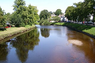
Kirkby Stephen is a market town and civil parish in Westmorland and Furness, Cumbria, England. Historically part of Westmorland, it lies on the A685, surrounded by sparsely populated hill country, about 25 miles (40 km) from the nearest larger towns: Kendal and Penrith. The River Eden rises 6 miles (9.7 km) away in the peat bogs below Hugh Seat and passes the eastern edge of the town. At the 2001 census the parish had a population of 1,832. In 2011, it had a population of 1,522.
Orton is a village and civil parish in Cumbria, England. It lies 15 miles (24 km) south of Penrith, 8 miles (13 km) from Appleby-in-Westmorland and 1.5 miles (2.4 km) from the M6 motorway. The village is in the upper Lune Valley, at the foot of Orton Scar in the Orton Fells. The Lake District is nearby. The parish includes a wide area outside the village, and had a population of 594 in 2001, decreasing to 588 at the 2011 Census.
The Vale of Eden is formed by the course of the River Eden, one of the major rivers of Northwest England. It is however of much greater extent than the actual valley of the river, lying between the Cumbrian Mountains, and the northern part of the Pennine Range. It lies entirely within the county of Cumbria. The river has its source in the peat bogs below Hugh Seat, in the dale of Mallerstang. At first it determinedly sets off South before turning back North for the rest of its course – except just before its outlet into the sea which it enters from the East.

Great Shunner Fell is the third highest mountain in the Yorkshire Dales, North Yorkshire, England, and the highest point in Wensleydale; at 716 metres above sea level. In clear weather the summit affords views of Wensleydale to the south, Ribblesdale to the south west and Swaledale to the north, as well as views into Cumbria and County Durham beyond the A66.

High Seat is a fell in the dale of Mallerstang, Cumbria. With a summit at 709 metres (2,326 ft), it is the fourth highest fell in the Yorkshire Dales after Whernside, Ingleborough and Great Shunner Fell. It is in the north-western part of the Dales, overlooking the deep trench of Mallerstang, and is usually climbed from this side.

Kirk Fell is a fell in the Western part of the English Lake District. It is situated between Great Gable and Pillar on the long ring of fells surrounding the valley of Ennerdale, and also stands over Wasdale to the south. However, it is separated from its two higher neighbours by the low passes of Black Sail and Beck Head, giving it a high relative height and making it a Marilyn, the thirteenth highest in the Lake District.

The Pennine Bridleway is a National Trail in Northern England.

Aisgill is the southernmost of the hamlets that form the parish of Mallerstang in the English county of Cumbria. It is on the B6259 road, at the head of Mallerstang dale, just before the boundary between Cumbria and North Yorkshire.

Mallerstang is a civil parish in the extreme east of Cumbria, and, geographically, a dale at the head of the upper Eden Valley. Originally part of Westmorland, it lies about 6 miles (9.7 km) south of the nearest town, Kirkby Stephen. Its eastern edge, at Aisgill, borders on North Yorkshire; and since August 2016 it has been within the Yorkshire Dales National Park.

Nine Standards Rigg is the summit of Hartley Fell in the Pennine Hills of England. It lies near the boundary between Cumbria and North Yorkshire, a few miles south-east of Kirkby Stephen and approximately 770 yards (700 m) outside the Yorkshire Dales National Park. Nine Standards Rigg lies within the North Pennines Area of Outstanding Natural Beauty (AONB). The name is derived from a group of cairns, the Nine Standards, located near the summit. The fell is listed as Nine Standards Rigg, rather than Hartley Fell, in Alan Dawson's book The Hewitts and Marilyns of England.

Great Knoutberry Hill, also commonly known as Widdale Fell, is a mountain located near Dent at the heads of Ribblesdale, Dentdale and Wensleydale, in the Yorkshire Dales National Park and within the boundaries of the historic county of Yorkshire. In fact, the borders between the West Riding and North Riding of Yorkshire meet at the summit, and the border between the modern administrative counties of Cumbria and North Yorkshire also runs over the fell. At a height of 2,205 feet (672 m) above sea level it is the 16th-highest fell in the Yorkshire Dales, with Rogan's Seat being exactly the same height.

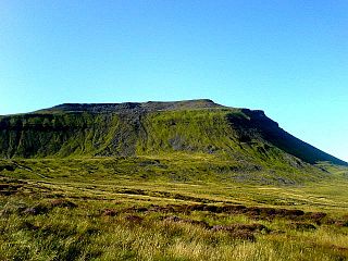
Wild Boar Fell is a mountain in the Yorkshire Dales National Park, on the eastern edge of Cumbria, England. At 2,323 feet (708 m), it is either the 4th-highest fell in the Yorkshire Dales or the 5th, depending on whether nearby High Seat (2,326 ft) is counted or not.

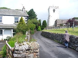
Outhgill is a hamlet in Mallerstang, Cumbria, England. It lies about 5 miles (8 km) south of Kirkby Stephen.

Pendragon Castle is a ruin located in Mallerstang Dale, Cumbria, south of Kirkby Stephen, and close to the hamlet of Outhgill. It stands above a bend in the River Eden, overlooked by Wild Boar Fell to the south-west and Mallerstang Edge to the east. It is a Grade I listed building.

Swarth Fell is an approximately 1 mile (1.5 km) stretch of high ground situated to the south of Wild Boar Fell, of which it is a continuation.
It is mostly within Mallerstang, Cumbria, but the boundary between Cumbria and North Yorkshire runs along its length, just to the west of the highest points.

Gregory Chapel is one of the high points of the fells on the border between Cumbria and North Yorkshire.
Little Fell may refer to:

Lady Anne's Way is a 100-mile (160 km) hiking route between Skipton and Penrith in Northern England. The trail is punctuated by houses and towers once owned by the Clifford family, but is named after Lady Anne Clifford who renovated and repaired the buildings in the 17th century. The route goes through Grassington, Buckden, Askrigg, Garsdale Head, Kirkby Stephen, Great Ormside, Appleby-in-Westmorland and Penrith.


