Cotterdale

Last updated

Cotterdale
Cotterdale - geograph.org.uk - 1543390.jpg
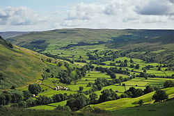
Cotterdale and the hamlet of the same name
North Yorkshire UK location map (2023).svg
Red pog.svg
Cotterdale
Location within North Yorkshire
Population12  [1]
OS grid reference SD833940
Civil parish
Unitary authority
Ceremonial county
Region
Country England
Sovereign state United Kingdom
Post town Hawes
Postcode district DL8
Police North Yorkshire
Fire North Yorkshire
Ambulance Yorkshire
UK Parliament
List of places
UK
England
Yorkshire
54°20′28″N2°15′36″W / 54.341°N 2.260°W / 54.341; -2.260

Cotterdale is a small side dale and hamlet on the north side of Wensleydale in North Yorkshire, England. The dale lies to the west of Great Shunner Fell. It is drained by East Gill and West Gill, which between them have nine waterfalls. They join to form Cotterdale Beck, which flows over three more waterfalls, including Cotter Force, below which the beck joins the River Ure. [2]

The place name is thought to be derived from the Old Norse kotar, meaning "huts". [3]

An Iron Age sword, with bronze scabbard, was found in Cotterdale, and is now in the British Museum. [4]

Related Research Articles

<span class="mw-page-title-main">River Wharfe</span> River in Yorkshire, England

The River Wharfe is a river in Yorkshire, England originating within the Yorkshire Dales National Park. For much of its middle course it is the county boundary between West Yorkshire and North Yorkshire. Its valley is known as Wharfedale.

<span class="mw-page-title-main">Malham Cove</span> Rock formation in North Yorkshire, England

Malham Cove is a large curved limestone formation 0.6 miles (1 km) north of the village of Malham, North Yorkshire, England. It was formed by a waterfall carrying meltwater from glaciers at the end of the last Ice Age more than 12,000 years ago. Today it is a well-known beauty spot and rock climbing crag within the Yorkshire Dales National Park. A large limestone pavement lies above the cove.

<span class="mw-page-title-main">Wensleydale</span> Upper valley of the River Ure in North Yorkshire, England

Wensleydale is a valley in North Yorkshire, England. It is one of the Yorkshire Dales, which are part of the Pennines. The dale is named after the village of Wensley, formerly the valley's market town. The principal river of the valley is the Ure, which is the source of the alternative name Yoredale. The majority of the dale is within the Yorkshire Dales National Park; the part below East Witton is within the national landscape of Nidderdale.

<span class="mw-page-title-main">Pen-y-ghent</span> Mountain in the Yorkshire Dales, England

Pen-y-ghent or Penyghent is a fell in the Yorkshire Dales, England. It is the lowest of Yorkshire's Three Peaks at 2,277 feet (694 m); the other two being Ingleborough and Whernside. It lies 1.9 miles (3 km) east of Horton in Ribblesdale. It has a number of interesting geological features, such as Hunt Pot, and further down, Hull Pot. The waters that flow in have created an extensive cave system which rises at Brants Gill head.

<span class="mw-page-title-main">River Eden, Cumbria</span> River in Cumbria, England

The River Eden is a river that flows through Cumbria, England. It rises on Black Fell Moss, near the village of Outhgill, and runs in a generally north-westerly direction through the Vale of Eden and Solway Plain before reaching the sea at the Solway Firth.

<span class="mw-page-title-main">River Ure</span> River in North Yorkshire, England

The River Ure in North Yorkshire, England, is about 74 miles (119 km) long from its source to the point where it becomes the River Ouse. It is the principal river of Wensleydale, which is the only major dale now named after a village rather than its river. The old name for the valley was Yoredale after the river that runs through it.

<span class="mw-page-title-main">Bishopdale, North Yorkshire</span> Valley in North Yorkshire, England

Bishopdale is a dale in the Yorkshire Dales National Park in North Yorkshire, England. The dale is a side dale on the south side of Wensleydale, and extends for some 6 miles (10 km) south west from Aysgarth. Bishopdale is also the name of a civil parish, which includes only the sparsely populated upper reaches of the dale, from the head of the dale as far downstream as Howesyke and Howgill Gill.

<span class="mw-page-title-main">Buckden, North Yorkshire</span> Village and civil parish in North Yorkshire, England

Buckden is a village and civil parish in the Craven district of North Yorkshire, England. Historically part of the West Riding of Yorkshire, Buckden is situated in the Yorkshire Dales National Park, and on the east bank of the River Wharfe in Wharfedale. The civil parish includes the hamlet of Cray and the whole of Langstrothdale. According to the 2011 Census the parish had a population of 187.

<span class="mw-page-title-main">Downholme</span> Village and civil parish in North Yorkshire, England

Downholme is a village and civil parish in North Yorkshire, England. It is situated approximately 4 miles (6 km) west from the market town of Richmond and 16 miles (26 km) west from the county town of Northallerton. The village lies close to the edge of the Yorkshire Dales. The population as taken in the ONS Census of 2011 was less than 100, so details are included in the parish of Hudswell. In 2015, North Yorkshire County Council estimated the population of the village to be 50.

<span class="mw-page-title-main">Appersett</span> Hamlet in Wensleydale, North Yorkshire, England

Appersett is a hamlet in the Yorkshire Dales in the Richmondshire district of North Yorkshire, England one mile (1.6 km) west of Hawes. It lies on the A684 road and an unclassified road runs alongside Widdale Beck to connect with the B6255 road between Hawes and Ingleton.

<span class="mw-page-title-main">West Stonesdale</span> Hamlet in North Yorkshire, England

West Stonesdale is a hamlet in the Yorkshire Dales, North Yorkshire, England. The secluded village is near Keld to the south, Tan Hill to the north and is both 10 miles (16 km) from Grinton and Askrigg. The small valley that cuts south from Tan Hill to West Stonesdale is also known as West Stonesdale and carries Stonesdale Beck 4 miles (7 km) south to the River Swale. A road heads north from the B6270 through West Stonesdale to Tan Hill. Where the road diverges from the B6270 is the site of Currack Force, a waterfall on Stonesdale Beck which drops 23 feet (7 m) before entering the Swale.

<span class="mw-page-title-main">West Burton, North Yorkshire</span> Village in North Yorkshire, England

West Burton is a village in Bishopdale, a side valley of Wensleydale, in the Yorkshire Dales, North Yorkshire, England. It lies 6.2 miles (10 km) south-west of Leyburn and 22.3 miles (35.9 km) west of the county town of Northallerton. It is the largest settlement in the civil parish of Burton-cum-Walden.

Foxup is a hamlet in the Yorkshire Dales in the Craven district of North Yorkshire, England. The hamlet is near Halton Gill and Litton and is 13 miles (21 km) north west of Grassington. Foxup is in the civil parish of Halton Gill.

<span class="mw-page-title-main">Cray, North Yorkshire</span> Hamlet in North Yorkshire, England

Cray is a hamlet on the B6160 road on a steep hill above Wharfedale in the Yorkshire Dales, North Yorkshire, England. It is near Buckden and the River Wharfe. It is a very popular walking area and is renowned for several waterfalls known collectively as Cray Waterfalls. The name of the settlement derives from the same name for the nearby beck ; Old Welsh Crei, meaning fresh. The settlement was not mentioned in the Domesday Book, first being recorded in 1202 when a meadow was granted as a fine to William de Arches at Creigate.

<span class="mw-page-title-main">River Skirfare</span> River in North Yorkshire, England

River Skirfare is a small river in North Yorkshire, England, that flows through Littondale and ends where it joins the larger River Wharfe. The source is the confluence of Foxup Beck and Cosh Beck at the hamlet of Foxup.

<span class="mw-page-title-main">Littondale</span> Dale in the former Craven District of North Yorkshire, England

Littondale is a dale in the former Craven District of the non-metropolitan county of North Yorkshire, England. It comprises the main settlements of Hawkswick, Arncliffe, Litton, Foxup and Halton Gill, and farmhouses that date from the 17th century. The main waterway in the dale is the River Skirfare which is fed by many small gills and becks.

<span class="mw-page-title-main">Cotter Force</span> Waterfall in North Yorkshire, England

Cotter Force is a small waterfall on Cotterdale Beck, a minor tributary of the River Ure, near the mouth of Cotterdale, a side dale in Wensleydale, North Yorkshire, England.

<span class="mw-page-title-main">Gunnerside Gill</span> Valley in North Yorkshire, England

Gunnerside Gill is a small valley in the Yorkshire Dales, England, which branches off Swaledale into moorland to the north of Gunnerside.

<span class="mw-page-title-main">Trollers Gill</span>

Trollers Gill is a limestone gill or gorge in North Yorkshire, England, close to the village of Skyreholme and 4.7 miles (7.5 km) south-east of Grassington in the Yorkshire Dales. The gorge, which is 0.5 miles (0.8 km) in length, is also known as Trollerdale.

<span class="mw-page-title-main">Cauldron Falls (North Yorkshire)</span> Waterfall in North Yorkshire, England

Cauldron Falls, is a series of waterfalls on Walden Beck in the village of West Burton, North Yorkshire, England. It is known as Cauldron Falls due to the swirls in the plunge pools beneath the cascades of the waterfall. The beck continues on underneath a packhorse bridge where there is another cascade.

References

  1. Aboutbritain.com website
  2. Bagshaw, Mike (2014). Slow Travel - Yorkshire Dales. Bradt Travel Guides. p. 116. ISBN   978 1 84162 549 2.
  3. Watts, Victor, ed. (2010), "Cotterdale", The Cambridge Dictionary of English Place-Names, Cambridge University Press, ISBN   978 0 521 16855 7
  4. "Kit guide:swords". Vicus. Archived from the original on 4 August 2007. Retrieved 17 August 2014.

Commons-logo.svg Media related to Cotterdale, North Yorkshire at Wikimedia Commons