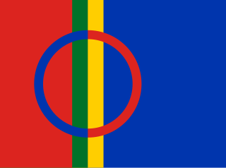
Sápmi is the cultural region traditionally inhabited by the Sámi people. Sápmi includes the northern parts of Fennoscandia, also known as the "Cap of the North".
Norrbotten County is the northernmost county or län of Sweden. It is also the largest county by land area, almost a quarter of Sweden's total area. It shares borders with Västerbotten County to the southwest, the Gulf of Bothnia to the southeast, the counties of Nordland and Troms in Norway to the northwest, and Lapland Province in Finland to the northeast.

The 25 provinces of Sweden are historical, geographical and cultural regions. They have no administrative function, but retain their own cultural identities, dialects and folklore.

The counties of Sweden are the first-level administrative subdivisions of Sweden. There are twenty-one counties; however, the number of counties has varied over time, due to territorial changes and to divisions and/or mergers of existing existing counties.

Norrland is the northernmost, largest and least populated of the three traditional lands of Sweden, consisting of nine provinces. Although Norrland does not serve any administrative purposes, it continues to exist as a historical, cultural, and geographic region; it is often referred to in everyday language, e.g., in weather forecasts. Several related Norrland dialects form a distinct subset of dialects of the Swedish language separate from those to its south.

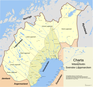
Västerbotten, sometimes called West Bothnia or Westrobothnia, is a province (landskap) in northern Sweden, located by the Gulf of Bothnia. It borders the provinces of Ångermanland, Lapland and Norrbotten. The region is famous for Västerbotten cheese.

Laponia was a historical Swedish province, or landscape, in the north of Sweden. It evolved from Lappmarken. In 1809, Sweden ceded the eastern part, along with Finland, to the Russian Empire, which in effect created a Swedish Lapland and Finnish Lapland.
Ostrobothnia is a historical province comprising a large western and northern part of modern Finland. It is bounded by Karelia, Savonia, Tavastia and Satakunta in the south, the Bothnian Sea, Bothnian Bay and Swedish Westrobothnia in the west, Laponia in the north and Russia in the east.

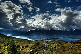
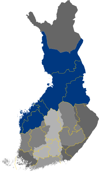
Lapland is the largest and northernmost region of Finland. The 21 municipalities in the region cooperate in a Regional Council. Lapland borders the Finnish region of North Ostrobothnia in the south. It also borders the Gulf of Bothnia, Norrbotten County in Sweden, Finnmark County and Troms County in Norway, and Murmansk Oblast and the Republic of Karelia in Russia. The topography of Lapland varies from vast mires and forests in the south to fells in the north. The Arctic Circle crosses Lapland, so polar phenomena such as the midnight sun and polar night can be viewed in this region.

Meänkieli, or Tornedalian is a Finnic language or a group of distinct Finnish dialects spoken in the northernmost part of Sweden along the valley of the Torne River. Meänkieli is recognized in Sweden as one of the country's five minority languages and is treated as a distinct language from Finnish, however its status as an independent Finnic language is sometimes disputed due to its mutual intelligibility with Finnish. According to the National Association of Swedish Tornedalians, 70,000 individuals are able to understand Meänkieli, at least to some level.
Kvenland, known as Cwenland, Qwenland, Kænland, and similar terms in medieval sources, is an ancient name for an area in Fennoscandia and Scandinavia. Kvenland, in that or nearly that spelling, is known from an Old English account written in the 9th century, which used information provided by Norwegian adventurer and traveler Ohthere, and from Nordic sources, primarily Icelandic. A possible additional source was written in the modern-day area of Norway. All known Nordic sources date from the 12th and 13th centuries. Other possible references to Kvenland by other names and spellings are also discussed here.

Muonio is a municipality of Finland. The town is located in fell-region of far northern Finland above the Arctic Circle on the country's western border with Sweden, the Muonio River. It lies within the area of the former Lappi (Lapland) province in the Fell Lapland subregion. The next closest Finnish municipalities are Enontekiö to the north, Kittilä on the east, and Kolari to the south. Southwest of the town, a road bridge crosses the Muonio River, across the river, in Sweden, lies the nearby hamlet of Muoniovaara in northern Pajala Municipality in Norrbotten County.

The Torne, also known as the Tornio, is a river in northern Sweden and Finland. For approximately half of its length, it defines the border between these two countries. In the upper parts, the river is situated in Sweden before it meets the Muonio River where it adjoins the international border. It rises at the lake Torneträsk near the border with Norway and flows generally southeast for a distance of 522 kilometres (324 mi) into the Gulf of Bothnia. It is the largest river in Norrbotten County both by length and by watershed area.
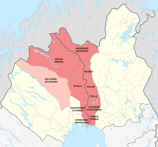
Meänmaa, or sometimes Torne Valley or Torne River Valley lies at the border of Sweden and Finland. It is named after the Torne River flowing through the valley and into the Gulf of Bothnia. Geographically the townships and municipalities that make up the area are Haparanda, Övertorneå, Pajala and Kiruna in Sweden, and Tornio, Ylitornio, Pello, Kolari, Muonio and Enontekiö in Finland. Culturally the highland Swedish municipality Gällivare is sometimes also considered part of Meänmaa due to the large share of Meänkieli-speaking population in it. Torne Valley should not be confused with Torne Valley Sub-region.

Tornedalians are an ethnic minority native to the Torne Valley (Meänmaa) region in northern Sweden and Finland. Tornedalians are since year 2000 a recognized national minority in Sweden. Tornedalians generally divide themselves into three distinct groups: Tornedalians, Kvens, and Lantalaiset.

The Skellefte River is a river in northern Sweden; one of the major Norrland rivers.

Lapland, also known by its Swedish name Lappland, is a province in northernmost Sweden. It borders the Swedish provinces of Jämtland, Ångermanland, Västerbotten, and Norrbotten, as well as Norway and Finland. Nearly a quarter of Sweden's land area is in Lappland.
Lappmarken was an earlier Swedish name for the northern part of the old Kingdom of Sweden inhabited by the Sami people. In addition to the present-day Swedish Lapland, it also covered Västerbotten, Jämtland and Härjedalen, as well as the Finnish Lapland. As a name, it is related to Finnmark, an old Norwegian name for the Sami area. "Finn" and "Lapp" are mutually exchangeable old names for the Sami people, although the latter is sometimes deemed offensive.

The Kalix River is one of the four major rivers of Norrland, northern Sweden, that are untouched by water power constructions. It is 461 kilometres long, flowing up to the Kebnekaise mountain range in Kiruna Municipality. In the southeast it flows through Lappland; and to the south through Norrbotten County, discharging in the Gulf of Bothnia south-east of Kalix.
Norrland dialects is one of the six major dialect groupings of the Swedish language. It comprises most dialects traditionally spoken in Norrland, except for those of Gästrikland and southern Hälsingland, which are usually classified as Svealand Swedish, as well as those of Härjedalen and northernmost Jämtland, which are usually classified as Norwegian.


