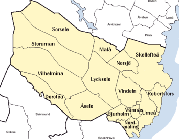
Västerbotten County

Last updated • 2 min readFrom Wikipedia, The Free Encyclopedia
Västerbotten County
Västerbottens län (Swedish)
Vasterbottens lan vapenflagga.svg
Vasterbotten lan vapen.svg
Vasterbottens lan in Sweden.svg
Västerbotten County in Sweden
Sweden Vasterbotten location map.svg
Location map of Västerbotten County in Sweden
Coordinates: 64°51′N17°54′E / 64.85°N 17.9°E / 64.85; 17.9
Country Sweden
Formed1638
Capital Umeå
Municipalities
Government
  Governor Helene Hellmark Knutsson (Social Democratic)
  Council Region Västerbotten
Area
  Total
55,186.2 km2 (21,307.5 sq mi)
Population
 (31 December 2023) [1]
  Total
278,729
  Density5.1/km2 (13/sq mi)
GDP
[2]
  TotalSEK 96 billion
€10.257 billion (2015)
Time zone UTC+1 (CET)
  Summer (DST) UTC+2 (CEST)
ISO 3166 code SE-AC
NUTS Region SE331
Website regionvasterbotten.se

Västerbotten County (Swedish : Västerbottens län), sometimes called Westrobothnia, is a county or län in the north of Sweden. It shares the borders with the counties of Västernorrland, Jämtland, and Norrbotten, as well as the Norwegian county of Nordland and the Gulf of Bothnia. Its capital is Umeå, and the largest town in the northern part is Skellefteå. These two municipalities make up the majority of the population. Västerbotten County has vast wilderness areas, and a land area larger than Denmark, the Netherlands and Switzerland.

Contents

Provinces

Map of the county circa 1796 Vasterbottens lan och svenska lappmarken 1796.svg
Map of the county circa 1796

For history, geography, and culture, see: Västerbotten, Lapland, and Ångermanland

Västerbotten County, also known as Västerbottens län in Swedish, is located in the northern part of Sweden. It shares borders with Västernorrland, Jämtland, and Norrbotten counties, as well as the Norwegian county of Nordland and the Gulf of Bothnia. The county's capital is Umeå, which is home to approximately half of the population when combined with the largest town in the northern part, Skellefteå. These two municipalities make up the majority of the population. The county boasts vast wilderness areas and has a land area larger than that of Denmark, the Netherlands or Switzerland.

Administration

The main aim of the County Administrative Board is to fulfil the goals set in national politics by the Riksdag and the Government, to co-ordinate the interests of the county, to promote the development of the county, to establish regional goals, and to safeguard the due process of law in the handling of each case. The County Administrative Board is a Government Agency headed by a Governor. See List of Västerbotten Governors.

Politics

The Regional Council of Västerbotten or Region Västerbotten.

Riksdag elections

The table details all Riksdag election results of Västerbotten County since the unicameral era began in 1970. The blocs denote which party would support the Prime Minister or the lead opposition party towards the end of the elected parliament.

YearTurnoutVotes V S MP C L KD M SD NyD LeftRight
1970 [3] 87.9145,7412.946.121.617.43.77.849.046.8
1973 [4] 90.1150,0363.945.026.211.83.98.548.946.5
1976 [5] 90.9159,4354.145.326.311.73.38.849.346.8
1979 [6] 90.4161,9415.446.521.012.53.310.751.944.2
1982 [7] 90.9165,3505.549.31.219.27.83.912.754.839.7
1985 [8] 89.4164,7485.748.51.218.114.511.354.243.9
1988 [9] 86.6159,3045.948.44.614.312.05.28.958.935.2
1991 [10] 86.4161,4485.445.33.312.69.98.610.83.950.741.9
1994 [11] 87.0166,3487.352.05.89.48.15.011.10.565.233.6
1998 [12] 82.1157,83915.743.24.96.65.410.711.763.834.5
2002 [13] 80.7155,36911.546.54.511.210.18.56.50.362.436.3
2006 [14] 82.9162,4908.443.95.911.86.46.513.71.158.138.3
2010 [15] 85.4170,59810.042.27.27.46.05.417.72.759.436.5
2014 [16] 86.9175,27911.042.05.96.74.44.313.87.458.929.0
2018 [17] 87.9178,83712.738.13.910.13.95.213.510.964.833.6
2022 [18] 85.8179,7128.540.75.47.83.14.714.214.562.436.5

Governors

Municipalities

Vasterbotten County.png

In Lapland Province:

In Västerbotten Province:

In Ångermanland Province:

Demographics

Foreign background

SCB have collected statistics on backgrounds of residents since 2002. These tables consist of all who have two foreign-born parents or are born abroad themselves. [19] The chart lists election years and the last year on record alone.

Location200220062010201420182019
Bjurholm 2.94.57.710.713.212.8
Dorotea 5.15.37.58.39.08.7
Lycksele 5.96.47.89.712.612.9
Malå 3.64.05.87.511.611.9
Nordmaling 3.84.36.08.510.811.0
Norsjö 3.03.87.09.611.411.2
Robertsfors 4.75.26.78.610.311.1
Skellefteå 4.45.66.68.210.010.3
Sorsele 3.15.410.212.313.413.3
Storuman 3.44.04.86.910.110.3
Umeå 9.410.311.712.714.915.5
Vilhelmina 3.23.56.28.59.59.4
Vindeln 3.74.56.49.112.212.8
Vännäs 4.04.15.78.39.49.6
Åsele 3.34.87.810.713.813.7
Total6.47.38.610.412.613.0
Source: SCB [19]

Heraldry

The arms for Västerbotten County is a combination of the arms of Västerbotten, Swedish Lapland, and Ångermanland. When it is shown with a royal crown, it represents the County Administrative Board. Blazon: "Parted per fess, base parted per pale, the arms of Västerbotten, the arms of Lapland, and the arms of Ångermanland."

See also

References and notes

  1. "Folkmängd i riket, län och kommuner 31 december 2023 och befolkningsförändringar 2023". Statistics Sweden. 31 December 2023. Retrieved 2 June 2024.
  2. Regions and Cities > Regional Statistics > Regional Economy > Regional GDP per Capita, OECD.Stats. Accessed on 16 November 2018.
  3. "Riksdagsvalet 1970" (PDF). SCB. Retrieved 21 September 2021.
  4. "Riksdagsvalet 1973" (PDF) (in Swedish). SCB. Retrieved 14 September 2021.
  5. "Riksdagsvalet 1976" (PDF) (in Swedish). SCB. Retrieved 14 September 2021.
  6. "Riksdagsvalet 1979" (PDF) (in Swedish). SCB. Retrieved 14 September 2021.
  7. "Riksdagsvalet 1982" (PDF) (in Swedish). SCB. Retrieved 14 September 2021.
  8. "Riksdagsvalet 1985" (PDF) (in Swedish). SCB. Retrieved 14 September 2021.
  9. "Riksdagsvalet 1988" (PDF) (in Swedish). SCB. Retrieved 14 September 2021.
  10. "Riksdagsvalet 1991" (PDF) (in Swedish). SCB. Retrieved 14 September 2021.
  11. "Riksdagsvalet 1994" (PDF) (in Swedish). SCB. Retrieved 14 September 2021.
  12. "Riksdagsvalet 1998" (PDF) (in Swedish). SCB. Retrieved 14 September 2021.
  13. "Valresultat Riksdag 2002" (in Swedish). Valmyndigheten. Archived from the original on 7 September 2021. Retrieved 14 September 2021.
  14. "Allmänna val 17 september 2006" (in Swedish). Valmyndigheten. Archived from the original on 28 September 2021. Retrieved 14 September 2021.
  15. "Röster - Val 2010" (in Swedish). Valmyndigheten. Archived from the original on 28 August 2018. Retrieved 14 September 2021.
  16. "Röster - Val 2014" (in Swedish). Valmyndigheten. Archived from the original on 11 November 2020. Retrieved 14 September 2021.
  17. "Röster - Val 2018" (in Swedish). Valmyndigheten. Archived from the original on 28 August 2018. Retrieved 14 September 2021.
  18. "Valpresentation". resultat.val.se (in Swedish). Retrieved 2023-01-26.
  19. 1 2 "PxWeb - välj variabler och värden" (in Swedish). SCB . Retrieved 11 August 2020.

64°20′41″N18°18′51″E / 64.344665°N 18.314209°E / 64.344665; 18.314209