[[Jönköping County]]
[[Halland County]]
[[Örebro County]]"},"unit_pref":{"wt":"Metric"},"area_footnotes":{"wt":""},"area_total_km2":{"wt":"16,694"},"area_land_km2":{"wt":""},"area_water_km2":{"wt":""},"area_water_percent":{"wt":""},"area_note":{"wt":""},"population_footnotes":{"wt":"{{cite web |url=https://www.statistikdatabasen.scb.se/pxweb/sv/ssd/START__BE__BE0101__BE0101A/FolkmangdDistrikt/table/tableViewLayout1/ |title=Folkmängd 31 december; ålder |website=Statistikdatabasen |access-date=1 June 2024 }}"},"population_total":{"wt":"1,410,554"},"population_as_of":{"wt":"31 December 2023"},"population_density_km2":{"wt":"auto"},"population_demonym":{"wt":""},"population_note":{"wt":""},"timezone1":{"wt":"[[Central European Time|CET]]"},"utc_offset1":{"wt":"+1"},"timezone1_DST":{"wt":"[[Central European Summer Time|CEST]]"},"utc_offset1_DST":{"wt":"+2"},"postal_code_type":{"wt":"[[List of postal codes in Sweden|Postal codes]]"},"postal_code":{"wt":""},"area_code_type":{"wt":"[[Telephone numbers in Sweden|Area codes]]"},"area_code":{"wt":""},"demographics_type1":{"wt":"Ethnicity"},"demographics1_title1":{"wt":"Language"},"demographics1_info1":{"wt":"[[Swedish language|Swedish]]"},"demographics1_title2":{"wt":"Dialect"},"demographics1_info2":{"wt":"[[Västgötska]], [[Gothenburg dialect]]"},"demographics_type2":{"wt":"Culture"},"demographics2_title2":{"wt":"Flower"},"demographics2_info2":{"wt":"[[Calluna|Heather]]"},"demographics2_title3":{"wt":"Animal"},"demographics2_info3":{"wt":"[[Crane (bird)|Crane]]"},"demographics2_title4":{"wt":"Bird"},"demographics2_info4":{"wt":"—"},"demographics2_title5":{"wt":"Fish"},"demographics2_info5":{"wt":"[[Burbot]]"},"website":{"wt":""},"footnotes":{"wt":""}},"i":0}}]}" id="mwBw">Historical province in Götaland, Sweden
Västergötland | |
---|---|
![]() | |
Country | ![]() |
Land | Götaland |
Counties | Västra Götaland County Jönköping County Halland County Örebro County |
Area | |
• Total | 16,694 km2 (6,446 sq mi) |
Population (31 December 2023) [1] | |
• Total | 1,410,554 |
• Density | 84/km2 (220/sq mi) |
Ethnicity | |
• Language | Swedish |
• Dialect | Västgötska, Gothenburg dialect |
Culture | |
• Flower | Heather |
• Animal | Crane |
• Bird | — |
• Fish | Burbot |
Time zone | UTC+1 (CET) |
• Summer (DST) | UTC+2 (CEST) |
Västergötland (Swedish: [ˈvɛ̂sːtɛrˌjøːtland] ), also known as West Gothland or the Latinized version Westrogothia in older literature, [2] is one of the 25 traditional non-administrative provinces of Sweden (landskap in Swedish), situated in the southwest of Sweden.
Västergötland is home to Gothenburg, the second largest city in Sweden, which is situated along a short stretch of the Kattegat strait. The province is bordered by Bohuslän, Dalsland, Värmland, Närke, Östergötland, Småland and Halland, as well as the two largest Swedish lakes Vänern and Vättern. Victoria, Crown Princess of Sweden is Duchess of Västergötland.
The provinces of Sweden serve no administrative function. Instead, that function is served by counties of Sweden. From the 17th century up until 31 December 1997, Västergötland was divided into Skaraborg County, Älvsborg County and a minor part of Gothenburg and Bohus County. From 1 January 1998 nearly all of the province is in the newly created Västra Götaland County, with the exception of Habo Municipality and Mullsjö Municipality, which were transferred to Jönköping County, and smaller parts of the province which are in Halland County and Örebro County.
Västergötland was granted its arms at the time of the funeral of King Gustav Vasa in 1560. The province is also a duchy and the arms can be represented with the ducal coronet. Blazon: "Per bend sinister Sable and Or, a Lion rampant counterchanged langued and armed Gules between two Mullets Argent in the Sable field."
The southern and eastern part of the province is dominated by hills, belonging to the southern Swedish highlands. In geological terms southern Västergötland is made up of northward tilted surfaces of the Sub-Cambrian peneplain making up the flank of the Southern Swedish Dome. [3]
The northern and western portions of the province belong to the Central Swedish lowland, which in this part is referred to as the Västgöta-plains or Västgötaslätten. Characteristic for these lowlands in Västergötland is that they contain hills made up Silurian-aged sedimentary rock. These are; Kinnekulle, Halleberg, Hunneberg and Billingen. [4]
Along the Kattegat lies the archipelago usually known as the Gothenburg archipelago. The southern part of it, belonging to Gothenburg Municipality, is part of Västergötland.
The northwestern border is demarcated by Sweden's largest lake Vänern, and the north-eastern border is demarcated by Sweden's second largest lake Vättern. Within the province the shoreline of Lake Vänern is 330 kilometres (210 mi) long, and along Vättern it is 130 km (81 mi). The largest river is Göta älv which drains Vänern to the east shore and the Kattegat strait; along the river several important cities and towns have been situated for centuries.
The average rainfall is 900 mm (35 in) near the coast and 600 mm (24 in) in the plains. The average temperature is −1 °C (30 °F) in January and 15 °C (59 °F) in July.
As of 31 December 2016, Västergötland had a population of 1,328,128 distributed over four counties: [1]
County | Population |
---|---|
part of Västra Götaland County | 1,305,659 |
part of Jönköping County | 18,812 |
part of Halland County | 2,126 |
part of Örebro County | 1,531 |
There are many ancient remains in Västergötland. Among the most notable of these remains are the dolmens from the Funnelbeaker culture, in the Falköping area south of lake Vänern. Finnestorp, near Larv, was a weapons sacrificial site from the Iron Age. [5]
The population of Västergötland, the Geats appear in the writings of the Greek Ptolemaios (as Goutai), and they appear as Gautigoths in Jordanes' work in the 6th century. The province of Västergötland represents the heartland of Götaland, once an independent petty kingdom with a long line of Geatish kings. These are mainly described in foreign sources (Frankish) and through legends. It is possible that Västergötland had the same king as the rest of Sweden at the time of the monk Ansgar's mission to Sweden in the 9th century, but both the date and nature of its inclusion into the Swedish kingdom is a matter of much debate. Some date it as early as the 6th century, based on the Swedish-Geatish wars in Beowulf epos; others date it as late as the 12th century.
Västergötland received much early influence from the British Isles and is generally considered to be the bridgehead of Christianity's advance into Sweden. Recent excavations at Varnhem suggest that at least its central parts were Christian in the 9th century. [6] Around 1000, King Olof Skötkonung is held to have received baptism in Husaby, near lake Vänern. However, the Christianization was met with heavy opposition in the rest of his kingdom, and so Olof had to restrict the Christian activities to Västergötland. The Christian faith spread, and by the time the provincial law Västgötalagen was written in the 13th century, Västergötland had 517 churches. The seat of the area's diocese seems to originally have been Husaby, but since 1150 the city of Skara (just some 20 kilometers; 10 miles south) held that distinction.
From the election of King Stenkil in the 11th century, Swedish and Geatish dynasties vied for the control of Sweden during long civil wars. For instance, the Swedish king Ragnvald Knaphövde was elected king by the Swedes, but when he entered Västergötland, he chose not to demand hostage from the powerful Geatish clans and was slain by the Geats near Falköping. Several times, Västergötland was independent from Sweden with kings such as Inge I of Sweden and Magnus the Strong. In later years the area was progressively tied more closely to the Swedish kingdom.
Being in peace with the rest of Sweden did not mean being in peace. Located along the borders of Denmark (with the so-called Scanian lands) and Norway (with Bohuslän), the area was often involved in armed disputes and invaded by hostile armies.
Some places and dates of early battles were the Battle of Älgarås (1205), the Battle of Lena (1208), the Battle of Hova (1275), the Battle of Gälakvist (1279) and the Battle of Falköping (1389). Thereafter, Sweden was involved in the Sweden-Danish wars; some notable years 1452, 1511, 1520, 1566, 1612, 1676.
In 1658, the current borders of Sweden were established when Sweden annexed both the Scanian lands and Bohuslän. Västergötland became less exposed as it was further from the country borders. Seaside battles at the end of Scanian War in the 1670s was the last combat on Västergötland soil.
Sources:
In 1634, the province was modernized with the establishment of two counties: Skaraborg County (with Skara as capital) and Älvsborg County (Capital first in Gothenburg but after 1679 in Vänersborg).
In Västergötland, the Götamål dialect of Swedish is spoken. The dialect has several varieties like the ones spoken in Gothenburg and Sjuhärad, but the main dialectal variety is the Western Götaland dialect, Västgötska.
The dialect was first dealt with as early as 1772, by S. Hofs in his Dialectus vestrogothica, which was a vocabulary with a grammar introduction.
Läckö Castle is situated on the island Kållandsö in the Vänern lake. It is generally regarded as one of Sweden's finest Baroque castles. The island was actually the location of a fortress as early as 1298, but the current building was begun in 1615, supervised first by Jacob De la Gardie and then finished by his son Magnus Gabriel de la Gardie.
Karlsborg Fortress, the largest fortress in Europe, is situated in the town of Karlsborg. [7] It is a testament to the "Central Defence Principle" of the 19th century, a reaction to the loss of Finland as a buffer state in 1809.
Bjurum manor, one of the largest Swedish manors in the country, is located in Västergötland.
Skara Cathedral is the oldest cathedral in the original parts of Sweden, i.e. if Scania is not included.
Hundreds of Sweden were sub-divisions of the Swedish provinces until the early 20th century. Several of Västergötland's hundreds were already described in the first written law for the province ( Västgötalagen ) in the 13th century. Västergötland's hundreds were:
The cities of Sweden were formerly chartered entities with certain privileges. Today they are municipalities.
The largest city, Gothenburg, is located by the western shore with a significant harbour commerce.
Football in the province is administered by Västergötlands Fotbollförbund.
The Göta älv is a river that drains lake Vänern into the Kattegat, at the city of Gothenburg, on the western coast of Sweden. It was formed at the end of the last glaciation, as an outflow channel from the Baltic Ice Lake to the Atlantic Ocean and nowadays it has the largest drainage basin in Scandinavia.
Vänern is the largest lake in Sweden, the largest lake in the European Union and the third-largest lake in Europe after Ladoga and Onega in Russia. It is located in the provinces of Västergötland, Dalsland, and Värmland in the southwest of the country. With its surface located at 44 metres (144 ft) with a maximum depth of 106 metres (348 ft), the lowest point of the Vänern basin is at 62 metres (203 ft) below sea level. The average depth is at a more modest 28 metres (92 ft), which means that the average point of the lake floor remains above sea level.
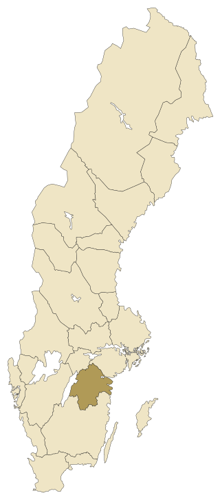
Västra Götaland County is a county or län on the western coast of Sweden.
Halland is one of the traditional provinces of Sweden (landskap), on the western coast of Götaland, southern Sweden. It borders Västergötland, Småland, Scania and the sea of Kattegat. Until 1645 and the Second Treaty of Brömsebro, it was part of the Kingdom of Denmark. Its name means Land of Rocky Slabs referring to the coastal cliffs of especially the northern part of the region.
The provinces of Sweden are historical, geographical and cultural regions. Sweden has 25 provinces; they have no administrative function but remain historical legacies and a means of cultural identification pertaining to dialects and folklore.
The Geats, sometimes called Goths, were a large North Germanic tribe who inhabited Götaland in modern southern Sweden from antiquity until the Late Middle Ages. They are one of the progenitor groups of modern Swedes, along with Swedes and Gutes. The name of the Geats also lives on in the Swedish provinces of Västergötland and Östergötland, the western and eastern lands of the Geats, and in many other toponyms.
Bohuslän (Swedish pronunciation:[ˈbûːhʉːsˌlɛːn] is a Swedish province in Götaland, on the northernmost part of the country's west coast. It is bordered by Dalsland to the northeast, Västergötland to the southeast, the Skagerrak arm of the North Sea to the west, and the county of Østfold, in Norway, to the north. In English it literally means Bohus County, although it shared counties with the city of Gothenburg prior to the 1998 county merger and thus was not an administrative unit in its own right.
Dalsland is a Swedish traditional province, or landskap, situated in Götaland in southern Sweden. Lying to the west of Lake Vänern, it is bordered by Värmland to the north, Västergötland to the southeast, Bohuslän to the west, and Norway to the northwest.
Götaland is one of three lands of Sweden and comprises ten provinces. Geographically it is located in the south of Sweden, bounded to the north by Svealand, with the deep woods of Tiveden, Tylöskog and Kolmården marking the border.
Älvsborg County was a county of Sweden until 1997, when it was merged with the counties of Gothenburg & Bohus and Skaraborg to form Västra Götaland County.
The Götaland theory is a view which challenges established history and archaeology, and claims that the foundation of Sweden occurred not in Eastern Sweden, but in the province of Westrogothia (Västergötland). The adherents of this idea use wide-ranging methods, from controversial ones, such as dowsing and asking mediums to contact the dead, to more conventional methods such as etymology, but also claim that the established academic material consists of lies and forgeries. Although well known in Sweden and fervently preached by its adherents, it has never been accepted by scholars.
Vänersborg is a locality and the seat of Vänersborg Municipality, Västra Götaland County, Sweden with 23,882 inhabitants Until 1997 it was the capital of Älvsborg County, which was dissolved in 1998. Since 1999 Vänersborg has been the seat of the regional parliament of Västra Götaland County. The city is located on the southern shores of lake Vänern, close to where the river Göta älv leaves the lake.
Skara is a locality and the seat of Skara Municipality, Västra Götaland County, Sweden with 18,580 inhabitants in 2013. Despite its small size, it is one of the oldest cities in Sweden, and has a long educational and ecclesiastical history. One of Sweden's oldest high schools, Katedralskolan, is situated in Skara. The former county of Skaraborg was named after a fortress near the town.
Karlsborg is a locality and the seat of Karlsborg Municipality, Västra Götaland County, Sweden. It had 3,551 inhabitants in 2010. This garrison town lies at the shore of lake Vättern in Västergötland.
Ätran is a Swedish river. The river is about 240 kilometres (150 mi) long, and has its source in Gullered, Västergötland, at a height of 332 metres (1,089 ft) above sea level. The river has its mouth in Falkenberg, Halland, where the river enters Kattegat.
Eskil Magnusson was a nobleman and lawspeaker (Lagman) of Västergötland. He is the first attested legal official in what is now Sweden about whom extensive information is available.
Vättern is the second largest lake by surface area in Sweden, after Vänern, and the sixth largest lake in Europe. It is a long, finger-shaped body of fresh water in south central Sweden, to the southeast of Vänern, pointing at the tip of Scandinavia. Being a deep lake at 128 metres (420 ft) below sea level at its deepest point, Vättern is about 1/3 the surface area of Vänern but in spite of this contains roughly 1/2 of its water.
Östergötland is one of the traditional provinces of Sweden in the south of Sweden. It borders Småland, Västergötland, Närke, Södermanland and the Baltic Sea. In older English literature, the Latinized version Ostrogothia is also used. The corresponding administrative county, Östergötland County, covers the entire province and parts of neighbouring provinces.
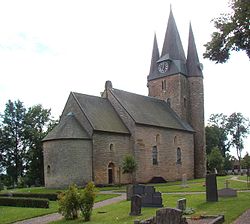
The Church ruins of Agnestad are church ruins in Falköping parish in Västra Götaland, Sweden.
Sweden held a general election on the 16 September 1973. Results are published by the Statistical Central Bureau.