
Catonsville is a census-designated place (CDP) in Baltimore County, Maryland. The population was 44,701 at the 2020 US Census. The community is a streetcar suburb of Baltimore along the city's western border. The town is known for its proximity to the Patapsco River and Patapsco Valley State Park, making it a regional mountain biking hub. The town is also notable as a local hotbed of music, earning it the official nickname of "Music City, Maryland." Catonsville contains the majority of the University of Maryland, Baltimore County (UMBC), a major public research university with close to 14,000 students.

The Maryland Transit Administration (MTA) is a state-operated mass transit administration in Maryland, and is part of the Maryland Department of Transportation. The MTA operates a comprehensive transit system throughout the Washington-Baltimore metropolitan area. There are 80 bus lines serving the Baltimore Metropolitan Area, along with rail services that include the Light Rail, Metro Subway, and MARC Train. In 2023, the system had a ridership of 52,922,000, or about 219,600 per weekday as of the second quarter of 2024.

West Baltimore station is a commuter rail station located in the western part Baltimore, Maryland, along the Northeast Corridor. It is served by MARC Penn Line trains. The station is positioned on an elevated grade at 400 Smallwood Street near parallel West Mulberry and West Franklin Streets extending off U.S. Route 40. Three large surface lots are available for commuters. The station only has staircases from street level and two low-level side platforms next to the outer tracks and is thus not accessible to people with some mobility disabilities, but MTA Maryland plans to renovate the station with accessible platforms and entrances.
QuickLink 40 is a limited stop bus route operated by the Maryland Transit Administration in Baltimore and its suburbs. Formerly the Quickbus 40, the line was discontinued in June 2017 as part of the BaltimoreLink system rebranding along with the other "Quickbus" limited-stop routes. On August 27, 2023, QuickBus 40, was re-launched after it was discontinued in 2017.

LocalLink 70 is a bus route operated by the Maryland Transit Administration between Baltimore and Annapolis, Maryland. At most times, the line operates from the Patapsco light rail station in southern Baltimore County with short turns at Jumper's Hole in Pasadena. The bus route, one of the longest local routes operated by MTA, is the successor to the Baltimore and Annapolis Railroad interurban, and mainly operates along the parallel Ritchie Highway, serving Brooklyn Park, Glen Burnie, Pasadena, and Severna Park. When the Light Rail is not running, the 70 runs all the way to downtown Baltimore, mostly along Hanover Street.
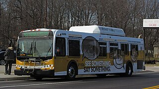
CityLink Orange is a bus route operated by the Maryland Transit Administration in Baltimore and its suburbs. The line currently runs from the Wal-Mart parking lot in Catonsville, Maryland east through downtown Baltimore to the Fox Ridge community in Essex, serving the corridors of Edmondson Avenue on the west side and Eastern Avenue on the east, and the communities of Edmondson Village, Allendale, Rosemont, Patterson Park, and Eastpoint, and is one of the most heavily used bus routes operated by the MTA.

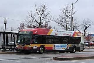
CityLink Purple is a bus route operated by the Maryland Transit Administration in Baltimore and its suburbs. The line currently runs from the Wal-Mart parking lot in Catonsville to Bullneck Road/Turner's Station Dundalk mostly along the corridors of Frederick Road on the west side and Eastern Avenue on the east side, serving the communities of Yale Heights, Pigtown, downtown Baltimore, Fells Point, and Highlandtown.
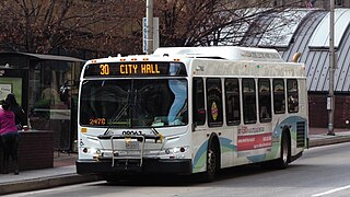
Route 30 was a bus route operated by the Maryland Transit Administration in Baltimore. The line ran from Edmondson Village in west Baltimore to Bayview Medical Center in southeast Baltimore during rush hour and City Hall during the midday until 20 February 2015.
Yale Heights is a neighborhood in the Southwest District of Baltimore, located between Beechfield (west) and Irvington (east). Most of its homes were built in 1955 as a development of two-bedroom, brick townhouses. These townhouses had an average value of $110,469 in 2022. The neighborhood's population in 2022 was estimated at 2,592.
Beechfield is a neighborhood in the Southwest District of Baltimore, located between Yale Heights (east) and the Baltimore County line (west). Its population in 2022 was estimated at 4,157.
Edgecomb, also known as Parklane, is a neighborhood in the North District of Baltimore, located between the neighborhoods of Cylburn (north) and Greenspring (south). Its boundaries are marked by Dupont Avenue (north), Coldspring Lane (south), Pimlico Road (west) and Greenspring Avenue (east). Central Park Heights, is located on the opposite side of Pimlico Road in the Northwest District. The neighborhood of Coldspring is located to Edgecomb's east, across Greenspring Avenue.

Beverly Hills is a neighborhood in the Northeast District of Baltimore, located between the neighborhoods of Moravia-Walther, Arcadia and Lauraville. Its boundaries are drawn by Harford Road (west), Weaver Avenue (south), Harcourt Road (east), Moravia Road (northeast) and Grindon Avenue (north).
Callaway-Garrison is a neighborhood in the Northwest district of Baltimore, located between the neighborhoods of Dorchester (west) and Ashburton (east). Its boundaries are marked by West Cold Spring Lane (north), Liberty Heights Avenue (south), Callaway Avenue (east) and Garrison Boulevard (west).

Bellona–Gittings is a neighborhood in the North District of Baltimore, located between the neighborhoods of Cedarcroft (east) and The Orchards (west). Its boundaries are marked by the Baltimore County line (north), East Melrose Avenue (south), Bellona Avenue (east) and North Charles Street (west). Many of the houses in this neighborhood were built from 1853 to 1956, with a wide variety of styles. Aside from one historic commercial building, the neighborhood is residential.
Hanlon Longwood is a neighborhood in the Northwest District of Baltimore, located between the neighborhoods of Garwyn Oaks (west) and Burleigh–Leighton (east). It is bounded by North Dukeland Street (east), Garrison Boulevard (west) and the Gwynns Falls Parkway (south). The neighborhood's north boundary is marked by North Longwood Street, North Hilton Street and Liberty Heights Avenue.
Langston Hughes is a neighborhood in the Northwest District of Baltimore, located between the neighborhoods of Central Park Heights (east) and Woodmere. Its roughly pentagonal boundaries are marked by West Belvedere Avenue (northwest), Litchfield Avenue (northeast), Reisterstown Road (south) and Oakmont Avenue (east).
West Hills is a neighborhood in the Southwest District of Baltimore, located between the neighborhoods of Westgate (south), Franklintown (north) and Hunting Ridge (east). Its boundaries are drawn by the Baltimore County line (west), Baltimore National Pike (south) and North Franklintown Road (north). Its eastern boundary follows Cooks Lane from Baltimore National Pike, then Briarclift Road and finally Wynans Way to the intersection with N. Franklintown Road.
Mount Holly is a neighborhood in the Southwest District of Baltimore, located between the neighborhoods of Fairmont (south), Walbrook (east) and Garwyn Oaks (north). Its boundaries are drawn by Denison Street (east), Clifton Avenue (southwest), Gwynns Falls Parkway (north), Windsor Mill Road (northwest), and West North Avenue (south). Gwynns Falls Leakin Park is located to the west of Mount Holly.
LocalLink 38 is a bus route operated by the Maryland Transit Administration in Baltimore between Westgate and Medfield. Primarily serving high school students traveling to the Baltimore Polytechnic Institute and Western High School campuses, the route was suspended on April 6, 2020, as schools closed during the 2020 coronavirus pandemic. The Maryland Transit Administration announced that the route would remain suspended on September 30, 2020, along with the LocalLink 92, while all other LocalLink routes would continue service. In Fall 2021, as Baltimore City Schools re-opened for in-person instruction, the MTA restored the LocalLink 38 route as a limited service for school trips on weekdays only. The bus departs from North Bend Loop, near the corner of North Bend Road and Edmondson Avenue just outside the western edge of the city border, and terminates at Poly Western High, near the intersection of Cold Spring Lane and Falls Road in north Baltimore, for two morning trips scheduled 5 minutes apart. Two reverse trips also scheduled 5 minutes apart run after school.
Rognel Heights is a neighborhood in the Southwest District of Baltimore, sandwiched between Hunting Ridge (west) and Edmondson Village (east) along Edmondson Avenue (south). Gwynns Falls/Leakin Park begins at the neighborhood's northern edge. Its boundaries are marked by Swann Avenue on the western edge, North Woodington Road on the east and Edmondson Avenue on the southern edge. The neighborhood of Uplands is located to the south of Rognel Heights, on the opposite side of Edmondson Avenue.


