
Fell's Point is a historic waterfront neighborhood in southeastern Baltimore, Maryland, established around 1763 along the north shore of the Baltimore Harbor and the Northwest Branch of the Patapsco River. Located 1.5 miles east of Baltimore's downtown central business district, Fells Point is known for its maritime history and character.

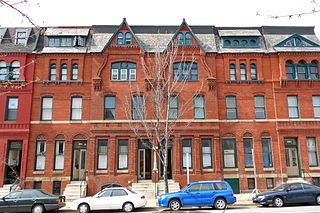
Mount Vernon is a neighborhood of Baltimore, Maryland, located immediately north of the city's downtown. It is named for George Washington's Mount Vernon estate in Virginia, as the site of the city's Washington Monument.

Canton is a historic waterfront neighborhood in Baltimore, Maryland, United States. The neighborhood is along Baltimore's outer harbor in the southeastern section of the city, roughly 2 miles (3 km) east of Baltimore's downtown district and next to or near the neighborhoods of Patterson Park, Fell's Point, Highlandtown, and Brewers Hill.
The Station North Arts and Entertainment District is an area and official arts and entertainment district in the U.S. city of Baltimore, Maryland. The neighborhood is marked by a combination of artistically-leaning commercial ventures, such as theaters and museums, as well as formerly abandoned warehouses that have since been converted into loft-style living. It is roughly triangular, bounded on the north by 20th Street, on the east by Greenmount Avenue, and on the south and west by the tracks of Amtrak's Northeast Corridor, though the neighborhood's boundaries include a one-block wide extension over the tracks.

Washington Hill is a neighborhood in Baltimore, Maryland, United States. It is north of Fells Point, south of Johns Hopkins Hospital, east of Old Town and Jonestown and west of Butchers Hill. It is bounded by Fayette Street, Washington Street, Lombard Street, and Central Avenue. The neighborhood surrounds Broadway running north from Fells Point to terminate at East North Avenue and is named for the now-defunct Washington Medical College later known as the Church Home and Hospital on Broadway where famed writer/poet Edgar Allan Poe was taken to die in 1849 after being found comatose in a downtown Baltimore street. In the median strip of Broadway is a statue of seven-term mayor of Baltimore, Ferdinand Claiborne Latrobe.

Keith Eugene Booth is an American basketball coach and former National Basketball Association (NBA) player. Booth played college basketball at the University of Maryland from 1993 to 1997. He was an assistant coach at his alma mater under Gary Williams from 2004 to 2011. He was also an assistant coach for G. G. Smith with the Loyola University Maryland men's basketball team.

Hamilton Hills is a mixed-use suburban neighborhood located in the northeastern corner of Baltimore, Maryland. Hamilton Hills represents a section of Hamilton, a larger historic area that includes other neighborhoods in Northeast Baltimore. The neighborhood's borders are Old Harford Road and Harford Road to the east, Echodale Avenue to the south, Perring Parkway to the west and the Baltimore County line to the north. The main thoroughfare in Hamilton Hills is Harford Road, which has been an integral part of the area's history.

Paul Laurence Dunbar High School is a public high school in Baltimore, Maryland, United States.

Middle East is a neighborhood in the heart of East Baltimore, Maryland.

Arlington is a neighborhood in Northwest Baltimore, Maryland. Major streets running through the area include Wabash Avenue, Rogers Avenue, Dolfield Avenue, and West Belvedere Avenue. Two Baltimore Metro Subway stations, Rogers Avenue and West Coldspring are located in the area.
Ashburton is a middle class, predominantly African-American neighborhood in the Forest Park region of northwestern Baltimore City, Maryland. It is located near Liberty Heights Avenue and Hilton Street, and is characterized by mixture of single family housing and blocks of row houses.

Broadway East is a neighborhood in the East District of Baltimore. Its boundaries are the south side of North Avenue, the west side of Milton Street, the east side of Broadway, and the north side of Biddle Street. The neighborhood lies east of Oliver, north of Middle East, south of Lake Clifton, and west of Berea.
Upper Fells Point, also known as "Fells Prospect," is a neighborhood of Baltimore, Maryland, United States. Located north of Fells Point, originally the neighborhood was home to Baltimore's dock workers. By the 1880s canneries and factories provided employment to new immigrants, including Irish, Italians and Poles. In the early 1900s these new Americans were joined by Jews, Lithuanians and Greeks. Today its tidy brick rowhouses and tree-lined streets are home to both old-timers and young urban professionals. It is also the heart of Baltimore's growing Latino community and is sometimes called "Spanish Town". Although most Hispanics in the neighborhood are Mexicans, there are significant populations of Salvadorans, Puerto Ricans, Hondurans, Dominicans, Guatemalans, Colombians, and Cubans, as well as many others.
Baltimore is the most populous city in the U.S. state of Maryland. With a population of 585,708 at the 2020 census, it is the 30th-most populous US city. Baltimore was designated as an independent city by the Constitution of Maryland in 1851, and is the most populous independent city in the nation. As of 2020, the population of the Baltimore metropolitan area was 2,838,327, the 20th-largest metropolitan area in the country. The city is also part of the Washington–Baltimore combined statistical area (CSA), which had a 2020 population of 9,973,383, the third-largest in the country. Though Baltimore is not located within or under the administrative jurisdiction of any county in the state, it is part of the Central Maryland region, together with the surrounding county that shares its name.
Frankford is a neighborhood in northeast Baltimore. Frankford is the most populous of the city's designated neighborhoods, with over 17,000 residents.

Hawkins Point is a neighborhood in the South District of Baltimore, located at the southern tip of the city between Curtis Bay (north) and the Anne Arundel County line (south) and Thoms Cove (east). Its land area covers 2.6 square miles (6.7 km2), and it had a population of 24 people according to the 2020 U.S. Census. The neighborhood is predominantly industrial.
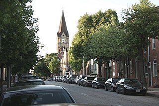
East Monument Historic District or Little Bohemia, is a national historic district in Baltimore, Maryland. It is a large residential area with a commercial strip along East Monument Street. It comprises approximately 88 whole and partial blocks. The residential area is composed primarily of rowhouses that were developed, beginning in the 1870s, as housing for Baltimore's growing Bohemian (Czech) immigrant community. During the late 19th and early 20th centuries the neighborhood was the heart of the Bohemian community in Baltimore. The Bohemian National Parish of the Roman Catholic Church, St. Wenceslaus, is located in the neighborhood. The historic district includes all of McElderry Park and Milton-Montford, most of Middle East and Madison-Eastend, and parts of Ellwood Park.

Poppleton is a neighborhood in west Baltimore, Maryland. The neighborhood is bounded on the north by West Mulberry Street, on the south by West Baltimore Street, on the west by North Carey Street, and on the east by the Martin Luther King Jr. Boulevard. Previously, Poppleton was construed in a broader sense extending further south to West Pratt Street or Lombard Street, but today this area is commonly described as the separate neighborhood of Hollins Market.
Levindale is a neighborhood in northwest Baltimore which includes Sinai Hospital, the Levindale Hebrew Geriatric Center and Hospital, and a small number of detached homes and apartment buildings towards its south.


