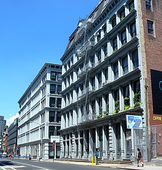
Greenmount West, Baltimore

Last updated
Greenmount West
Greenmount West.jpg
Street art on the side of a rowhouse in Greenmount West
Country United States
State Maryland
City Baltimore
Time zone UTC-5 (Eastern)
  Summer (DST)EDT
ZIP code
21201 [1]
Area code 410, 443, and 667

Greenmount West is a neighborhood in the state-designated Station North Arts District of Baltimore. Its borders consist of Hargrove Alley to the west, Hoffman Street and the Amtrak railroad tracks to the south, the south side of North Avenue to the north, and Greenmount Avenue to the east. [2] Residents in the area include a mix of low, middle and high income families, artists, commuters to Washington DC and working-class Baltimoreans with the majority of residents of African American descent.

Contents

The neighborhood was one of many affected by the Baltimore riot of 1968. For years, the area suffered from urban decay, housing abandonment and crime, but in recent times the area has experienced a resurgence. Artists have created live/work space in the sprawling former Crown Cork and Seal factory buildings (commonly known as the Copycat Building) along the railroad tracks. Small developers are rehabbing the two and three story rowhouses for market rate homeownership. Pocket parks like McAllister Park, Hunters Lot and Brentwood Commons were created in the area, and the neighborhood's 2002 designation as an Arts and Entertainment District further catalyzed development. The real estate bubble of the 2000s caused Baltimore's housing prices to skyrocket, and drove home buyers seeking out cheaper areas on the upswing to the neighborhood. Housing sales in 2009 ranged between $169,000 - $320,000.[ citation needed ]

Local attractions

Greenmount West is within walking distance to the Maryland Institute College of Art; Penn Station is directly south, providing walking-distance access to Amtrak, Light Rail and MARC commuter rail service (the latter being of particular interest to those commuting to Washington, D.C.). Mt. Vernon, Baltimore borders the neighborhood to the south.

Historic Green Mount Cemetery, located at 1501 Greenmount Avenue, is the final resting place of many famous and infamous Maryland and Baltimore figures (Enoch Pratt, John Wilkes Booth). The neighborhood was the early high school Baltimore home of the now deceased rapper Tupac Shakur.

As part of the Station North Arts and Entertainment District, Greenmount West is also within walking distance of the commercial district on Charles Street. This area includes attractions such as the Charles Theatre, a popular art house multiplex and many other businesses, arts spaces, and galleries. One block away is the Charm City Art Space which serves as a music venue and art gallery.

The Baltimore-based HBO drama The Wire was filmed here. Baltimore Montessori Public Charter School Archived 2016-03-07 at the Wayback Machine opened in the former Mildred Monroe Elementary School (The Wire's Primary School 32) in September 2008 and a graphic designer's letterpress now inhabits The Wire's "Bubbles Garage". City Arts, affordable housing for artists at 440 E. Oliver Street which includes a gallery space, opened in November 2010.

Maryland Arts and Entertainment District designation

The neighborhood's 2002 designation of the area as an arts district has furthered the neighborhood's transformation. The earliest and most visible signs of change were the official conversion of several industrial and warehouse buildings to mixed-use housing. These buildings had been in use for decades as artist's studios and (illegal) housing, and contributed toward the area winning arts district status under then-mayor Martin O'Malley. Such designation paved the way for these buildings to be rezoned for residential use. [3]

In Maryland, the State Department of Business and Economic Development designates certain neighborhoods “arts and entertainment districts”, which confers three specific tax breaks. Artists who live and work in the district are offered property-tax credits on qualifying renovations, can apply for an income-tax credit when they make money on their art, and are given a waiver of the admissions and amusement tax charged by the city. [4] Artists who live or work in Station North may qualify for certain tax breaks by submitting Form 502AE (Subtraction For Income Derived Within An Arts and Entertainment District) with their Maryland Tax Returns. Major tax benefits concerning building usage are also in place, with assessment freezes and building rehab credits to encourage growth.[ citation needed ]

Future development

As a part of the Station North Arts and Entertainment District, current plans for Greenmount West call for a major transformation of the neighborhood.

A 2006 Action Plan Report, prepared by Randall Gross / Development Economics, the Baltimore Neighborhood Collaborative, and Station North Arts & Entertainment, Inc., focuses on four key strategies for Station North: To strengthen positive image and identity, to establish commercial corridors, to provide housing options to attract new residents while preventing displacement of existing residents, and to encourage economic development. [5]

In early 2010, construction began on City Arts, a $15 million housing development for artists. Located at 440 East Oliver Street in Greenmount West and consisting of 69 apartments for rent and eight town houses for sale, City Arts will be the first all-new housing project in the 100-acre (0.40 km2) arts district since a $1 billion "vision plan" was unveiled for the area in 2008. [6] The building will consist of four stories of apartments, a multipurpose first-floor space provided for artistic use by the residents, and thirty-five off-street parking spaces. Key to the project’s plans are financing regulations that will ensure the space remains affordable to artists even as the neighborhood changes. [7] The project was featured on CNN as an example of how federal Recovery Act money has restarted development that stalled during the economic downturn. [8]

Related Research Articles

<span class="mw-page-title-main">SoHo, Manhattan</span> Neighborhood in Manhattan, New York

SoHo, sometimes written Soho, is a neighborhood in Lower Manhattan, New York City. Since the 1970s, the neighborhood has been the location of many artists' lofts and art galleries, and has also been known for its variety of shops ranging from trendy upscale boutiques to national and international chain store outlets. The area's history is an archetypal example of inner-city regeneration and gentrification, encompassing socioeconomic, cultural, political, and architectural developments.

<span class="mw-page-title-main">Hampden, Baltimore</span> Neighborhood of Baltimore in Maryland, United States

Hampden is a neighborhood located in northern Baltimore, Maryland, United States. Roughly triangular in shape, it is bounded to the east by the neighborhood Wyman Park, to the north by Roland Park at 40th and 41st Street, to the west by the Jones Falls Expressway, and to the south by the neighborhood Remington. The Homewood campus of the Johns Hopkins University is a short distance to the east.

<span class="mw-page-title-main">Red Emma's</span> Radical infoshop located in Baltimore, Maryland, USA and run by a worker-owner collective

Red Emma's Bookstore Coffeehouse is a radical infoshop located in Baltimore, Maryland, United States and run by a worker-owner collective. Named for anarchist Emma Goldman, Red Emma's opened in November 2004 and sells fair trade coffee, vegetarian and vegan foods and books. The space also provides free computer access to the Baltimore community, wireless internet and film screenings, political teach-ins, and community events.

<span class="mw-page-title-main">Mount Vernon, Baltimore</span> Neighborhood in Baltimore, Maryland, United States

Mount Vernon is a neighborhood of Baltimore, Maryland, located immediately north of the city's downtown. It is named for George Washington's Mount Vernon estate in Virginia, as the site of the city's Washington Monument.

<span class="mw-page-title-main">Charles Village, Baltimore</span> Neighborhood of Baltimore in Maryland, United States

Charles Village is a neighborhood located in the north-central area of Baltimore, Maryland, USA. It is a diverse, eclectic, international, largely middle-class area with many single-family homes that is in proximity to many of Baltimore's cultural amenities. Nearby are the Baltimore Museum of Art, The Homewood campus of The Johns Hopkins University, Olmstead's Wyman Park, and the weekly Waverly Farmers Market, and the arts district, Station North. Homes are exemplary Baltimore brick and stone row houses, many dating from the 1890s. Running from downtown north is the historic boulevard, Charles Street, where Baltimore's Easter Promenade once took place.

<span class="mw-page-title-main">Bolton Hill, Baltimore</span> Neighborhood of Baltimore in Maryland, United States

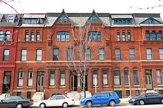
Bolton Hill is a neighborhood in Baltimore, Maryland, with 20 blocks of mostly preserved buildings from the late 19th century. It is listed on the National Register of Historic Places, preserved as a Baltimore City Historic District, and included within the boundaries of Baltimore National Heritage Area. The neighborhood is bounded by North Avenue, Mount Royal Avenue, Cathedral Street, Dolphin Street, and Eutaw Place. Bolton Hill is a largely residential neighborhood with three-story row houses with red brick, white marble steps, and high ceilings. There are also larger more ornate originally single-family houses, many houses of worship, parks, monuments, and a few large apartment buildings. Many significant residents have lived in the neighborhood, including F. Scott Fitzgerald, Woodrow Wilson, the Cone sisters, and Florence Rena Sabin.

<span class="mw-page-title-main">Downtown Kansas City</span> Place in Missouri, United States

Downtown Kansas City is the central business district (CBD) of Kansas City, Missouri and the Kansas City metropolitan area which contains 3.8% of the area's employment. It is between the Missouri River in the north, to 31st Street in the south; and from the Kansas–Missouri state line eastward to Bruce R. Watkins Drive as defined by the Downtown Council of Kansas City; the 2010 Greater Downtown Area Plan formulated by the City of Kansas City defines the Greater Downtown Area to be the city limits of North Kansas City and Missouri to the north, the Kansas–Missouri state line to the west, 31st Street to the south and Woodland Avenue to the east. However, the definition used by the Downtown Council is the most commonly accepted.

<span class="mw-page-title-main">Pigtown, Baltimore</span> Neighborhood in southwest Baltimore

Pigtown is a neighborhood in the southwest area of Baltimore, bordered by Martin Luther King Jr. Boulevard to the east, Monroe Street to the west, Russell Street to the south, and West Pratt Street to the north. The neighborhood acquired its name during the second half of the 19th century, when the area was the site of butcher shops and meat packing plants to process pigs transported from the Midwest on the B&O Railroad; they were herded across Ostend and Cross Streets to be slaughtered and processed.

<span class="mw-page-title-main">Station North Arts and Entertainment District</span> Neighborhood of Baltimore in Maryland, United States

The Station North Arts and Entertainment District is an area and official arts and entertainment district in the U.S. city of Baltimore, Maryland. The neighborhood is marked by a combination of artistically-leaning commercial ventures, such as theaters and museums, as well as formerly abandoned warehouses that have since been converted into loft-style living. It is roughly triangular, bounded on the north by 20th Street, on the east by Greenmount Avenue, and on the south and west by the tracks of Amtrak's Northeast Corridor, though the neighborhood's boundaries include a one-block wide extension over the tracks.

The Near East Side is a neighborhood located near downtown Columbus, Ohio, made up of several neighborhoods: Mount Vernon, King-Lincoln Bronzeville, Eastgate, Franklin Park, Nelson Park, Olde Towne East, and Woodland Park.

<span class="mw-page-title-main">Downtown Baltimore</span> Place in Maryland, United States

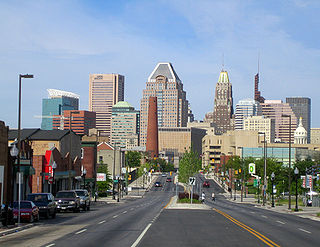
Downtown Baltimore is the central business district of the city of Baltimore traditionally bounded by Martin Luther King, Jr. Boulevard to the west, Franklin Street to the north, President Street to the east and the Inner Harbor area to the south.

<span class="mw-page-title-main">Waverly, Baltimore</span> Neighborhood statistical area in Baltimore, Maryland, United States

Waverly is a neighborhood in the north central area of Baltimore, Maryland, located to the north of the adjacent same neighborhood called Better Waverly and west of Ednor Gardens-Lakeside, north and east of Charles Village west of the area of Coldstream-Homestead-Montebello neighborhoods, along with the campus of the former red brick H-shaped building for Eastern High School (1938–1984), facing north towards 33rd Street, now renovated since the 1990s into offices for The Johns Hopkins University, a mile to the west. Adjacent to the east of the Eastern High/Johns Hopkins campus is the landmark tree-shaded campus of The Baltimore City College, at 33rd Street and The Alameda. The College is a massive stone structure with a 150-foot bell tower visible for miles, nicknamed "The Castle on the Hill", constructed 1926–1928 of Collegiate Gothic architecture on one of the highest hills in the city, "Collegian Hill", with the downtown skyline visible to the south. City College is the third oldest public high school in America, founded 1839 in downtown has been through eight different sites in its 179 years of history and five major buildings, each were architectural landmarks in their times. From its beginnings, until 1979, it was a single sex secondary school for boys in the Baltimore City Public Schools, when it co-educated admitting young women. These three major institutions and their sports events dominated the east side of Waverly/Better Waverly for nine decades.

<span class="mw-page-title-main">Oliver, Baltimore</span> Neighborhood of Baltimore in Maryland, United States

Oliver is a neighborhood in the Eastern district of Baltimore, Maryland. Its boundaries are the south side of North Avenue, the east side of Ensor Street, the west side of Broadway, and the north side of Biddle Street. This neighborhood, adjacent to Johns Hopkins Medical Campus and minutes from the Inner Harbor, lies east of the historic Greenmount Cemetery. The neighborhood is accessible by several bus lines, the Johns Hopkins metro station, Charm City Circulator, Pennsylvania Station (Baltimore), and freeway.

<span class="mw-page-title-main">Barclay, Baltimore</span> Neighborhood of Baltimore in Maryland, United States

Barclay is a neighborhood in the center of Baltimore City. Its boundaries, as defined by the City Planning Office, are marked by North Avenue, Greenmount Avenue, Saint Paul and 25th Streets. The neighborhood lies north of Greenmount West, south of Charles Village, west of East Baltimore Midway, and east of Charles North and Old Goucher. The boundary between the Northern and Eastern police districts runs through the community, cutting it roughly in half.

<span class="mw-page-title-main">East Baltimore Midway, Baltimore</span> Neighborhood in Baltimore

East Baltimore Midway is a neighborhood in the Eastern district of Baltimore, Maryland. Its boundaries are the south side of 25th Street, the east side of Greenmount Avenue, the west side of Harford Road, and the north side of North Avenue.
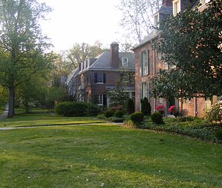
<span class="mw-page-title-main">Harwood, Baltimore</span> Neighborhood of Baltimore in Maryland, United States

Harwood is a small neighborhood located in the north-central area of Baltimore, Maryland, USA. It sits east of Charles Village, south of Abell, west of Waverly and north of Barclay. Its boundaries are Guilford and Greenmount Avenues to the east and west, and 25th and 29th streets to the north and south. These streets together encompass about 14 city blocks.

<span class="mw-page-title-main">Poppleton, Baltimore</span> Neighborhood in Baltimore

Poppleton is a neighborhood in west Baltimore, Maryland. The neighborhood is bounded on the north by West Mulberry Street, on the south by West Baltimore Street, on the west by North Carey Street, and on the east by the Martin Luther King Jr. Boulevard. Previously, Poppleton was construed in a broader sense extending further south to West Pratt Street or Lombard Street, but today this area is commonly described as the separate neighborhood of Hollins Market.

Better Waverly is a neighborhood in the North District of Baltimore, located between the neighborhoods of Charles Village (west) and Coldstream-Homestead-Montebello (east). Its boundaries are marked by East 33rd Street (north), Exeter Hall Avenue (south), Greenmount Avenue (west) and Loch Raven Road (east).

<span class="mw-page-title-main">Midtown-Edmondson, Baltimore</span> Neighborhood of Baltimore in Maryland, United States

Midtown-Edmondson is a mixed-use neighborhood in western Baltimore City developed mostly between the 1880s and the 1910s. The neighborhood is mainly composed of residential rowhouses, with a mixed-used business district along Edmondson Avenue, and industrial warehouses and buildings dotted along the CSX railroads that bound its western edge.

Baltimore Design School is a public charter middle/high school located in Baltimore, Maryland, United States. The school occupies the former Lebow Brothers Clothing Factory in the Greenmount West neighborhood, part of the Station North Arts and Entertainment District. The school was modeled on, and intended to complement, the Baltimore School for the Arts, which focuses on the performing arts. By contrast, Baltimore Design School's stated aim is to provide its students with "a solid foundation of design and studio skills followed by intensive academics and design study", by completion of four years of study in one of three tracks in architecture-construction design and management, graphic design-interactive media production, or fashion design, followed by three years of CTE training.

References

  1. "Medfield neighborhood in Baltimore, Maryland (MD), 21211 subdivision profile - real estate, apartments, condos, homes, community, population, jobs, income, streets". www.city-data.com.
  2. Jensen, Brennen. "Greenmount West". Live Baltimore. Retrieved January 15, 2010.
  3. Jensen, Brennen (May 8, 2002). "For Industry to Easels - Arts District Designation Easing Conversion of Factories to Studios". Baltimore City Paper. Archived from the original on July 8, 2011. Retrieved January 14, 2010.
  4. Dickinson, Elizabeth Evitts (July 2007). "The SoHo Effect: In a creative-class economy, cities are increasingly banking on artists to save neighborhoods. Can Station North cash in without selling out?". Urbanite Magazine. Archived from the original on November 18, 2007. Retrieved January 14, 2010.
  5. "Action Plan Report: Station North Strategic Plan" (PDF). August 2006. Retrieved January 15, 2010.[ permanent dead link ]
  6. Gunts, Edward (January 8, 2010). "InConstruction begins on City Arts housing for artists". Baltimore Sun. Archived from the original on July 19, 2012. Retrieved January 15, 2010.
  7. Gunts, Edward (June 25, 2009). "Development Spotlight: City Arts". Urban Discoveries Baltimore. Retrieved January 15, 2010.[ permanent dead link ]
  8. Endo, Sandra (September 22, 2009). "Neighborhood Gets A Makeover". CNN. Retrieved January 15, 2010.

39°18′33″N76°36′41″W / 39.30917°N 76.61139°W / 39.30917; -76.61139