
Reisterstown is an unincorporated community and census-designated place in Baltimore County, Maryland, United States. As of the 2010 census, it had a population of 25,968.

Druid Hill Park is a 745-acre (3.01 km2) urban park in northwest Baltimore, Maryland. Its boundaries are marked by Druid Park Drive (north), Swann Drive and Reisterstown Road, and the Jones Falls Expressway / Interstate 83 (east).
Oella is a mill town on the Patapsco River in western Baltimore County, Maryland, United States, located between Catonsville and Ellicott City. It is a 19th-century village of millworkers' homes.

Mount Washington is an area of northwest Baltimore, Maryland. It is a designated city historic district and divided into two sections: South Road/Sulgrave to the southeast and Dixon's Hill to the north. The Mount Washington Historic District was listed on the National Register of Historic Places in 1990 with a boundary increase in 2001, with five contributing buildings and four contributing structures.
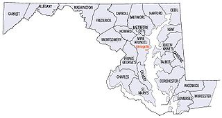
There are more than 1,500 properties and districts listed on the National Register of Historic Places in the U.S. State of Maryland. Each of the state's 23 counties and its one county-equivalent has at least 20 listings on the National Register.

Reservoir Hill, is a historic neighborhood in the city of Baltimore, Maryland, United States. It is located south of Druid Hill Park, north of Bolton Hill, east of Penn-North, and west of Jones Falls. It is bounded by Druid Park Lake Drive, the Jones Falls Expressway, North Avenue, and McCulloh Street. It is contained in the 21217 ZIP code.

Butchers Hill is a neighborhood in Southeast Baltimore, Maryland, United States. It is north of Fells Point, east of Washington Hill, and northwest of Patterson Park. It is south of Fayette Street, west of Patterson Park Avenue, north of Pratt Street, and east of Washington Street. It is in the 21231 zip code.

Woodland Terrace is a street name and a small neighborhood of twin mansions in the West Philadelphia section of Philadelphia, Pennsylvania, United States. It was listed as a historic district on the National Register of Historic Places on March 16, 1972. The street runs from Baltimore Avenue to Woodland Avenue between 40th and 41st streets.
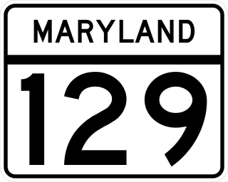
Maryland Route 129 is a state highway in the U.S. state of Maryland, running north-northwesterly from U.S. Route 40 and MD 295 in the city of Baltimore into Baltimore County, ending at Garrison Forest Road east of Reisterstown. The route leaves downtown on the one-way pair of McCulloh Street and Druid Hill Avenue, and then uses the entire length of Park Heights Avenue to the end. MD 129 connects Downtown Baltimore with Druid Hill Park using McCulloh Street and Druid Hill Avenue. As Park Heights Avenue, the state highway is one of two primary radial routes in the northwestern part of the city, providing access to The Maryland Zoo and Pimlico Race Course. In Baltimore County, MD 129 passes through Pikesville, where it has a junction with Interstate 695 (I-695) and serves an affluent rural area north of Pikesville and east of Reisterstown.

Sudbrook Park is a historic neighborhood near Pikesville, Maryland located just northwest of the Baltimore City limits in Baltimore County.

Homeland is a neighborhood in the northern part of Baltimore, Maryland, United States. It is bounded roughly by Melrose Avenue on the north, Bellona Avenue on the east, Homeland Avenue on the south, and Charles Street on the west.

Mayfield is a quaint and historic community in northeast Baltimore, Maryland. It is bounded by Erdman Avenue on the south, Chesterfield Avenue on the north, Crossland Avenue on the east and Lake Montebello on the north and west. Homeowners belong to the Mayfield Improvement Association.

The First Unitarian Church is a historic church and congregation at 12 West Franklin Street in Mount Vernon, Baltimore, Maryland. Dedicated in 1818, it was the first building erected for Unitarians in the United States. The church is a domed cube with a stucco exterior. The church, originally called the "First Independent Church of Baltimore", is the oldest building continuously used by a Unitarian congregation. The name was changed in 1935 to "The First Unitarian Church of Baltimore " following the merger with the former Second Universalist Church at East Lanvale Street and Guilford Avenue in midtown Baltimore. The American Unitarian Association and the Universalist Church of America (established 1866) representing the two strains of Unitarian Universalism beliefs and philosophies merged as a national denomination named the Unitarian Universalist Association in May 1961.

Seton Hill Historic District is a historic district in Baltimore, Maryland. It was listed on the National Register of Historic Places in 1975.
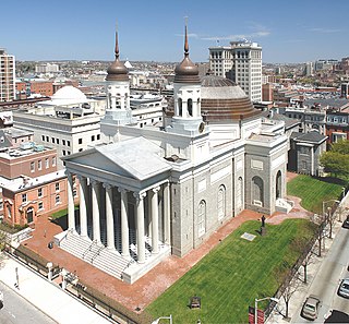
The Cathedral Hill Historic District is an area in Baltimore, Maryland. It lies in the northern part of Downtown just south of Mount Vernon. Roughly bounded by Saratoga Street, Park Avenue, Hamilton Street, and St. Paul Street, these 10 or so blocks contain some of the most significant buildings in Baltimore. The area takes its name from the Basilica of the Assumption which sits in the heart of the district. Despite the number of large religious structures in the area, the district's buildings are primarily commercial in character, with a broad collection of significant commercial structures ranging in date from 1790 to 1940.

The National Register of Historic Places listings in the city of Baltimore, Maryland covers the more than 300 properties and historic districts listed on the National Register of Historic Places in the independent city of Baltimore, Maryland. NRHP listings in Baltimore County, which surrounds but does not include the city, are in the National Register of Historic Places listings in Baltimore County, Maryland.

Eastern Female High School, also known as Public School No. 116, is a historic female high school located on the southeast corner of the 200 block of North Aisquith Street and Orleans Street, in the old Jonestown / Old Town neighborhoods, east of Downtown Baltimore and now adjacent to the recently redeveloped Pleasant View Gardens housing project / neighborhood of Baltimore, Maryland, United States. It was built in 1869-1870 and is typical of the Italian Villa mode of late 19th-century architecture. It was dedicated in a large ceremony with speeches later published in a printed phamplet and attending crowds in early 1870. Old Eastern High is a two-story brick structure that features a square plan, three corner towers, and elaborate bracketing cornices, with a similar wood decorated porch/portico over front entrance on its west side facing Aisquith Street.

Baltimore East/South Clifton Park Historic District is a national historic district in Baltimore, Maryland, United States. It is primarily an urban residential area organized in a gridiron pattern. It comprises approximately 110 whole and partial blocks that formed the historic northeast corner of the City of Baltimore prior to 1888. While rowhouses dominate the urban area, the historic district also contains other property types which contribute to its character including brewing, meat packing, cigar manufacturing, printing, and a tobacco warehouse. The Baltimore Cemetery completes the historic district.

East Monument Historic District or Little Bohemia, is a national historic district in Baltimore, Maryland. It is a large residential area with a commercial strip along East Monument Street. It comprises approximately 88 whole and partial blocks. The residential area is composed primarily of rowhouses that were developed, beginning in the 1870s, as housing for Baltimore's growing Bohemian (Czech) immigrant community. During the late 19th and early 20th centuries the neighborhood was the heart of the Bohemian community in Baltimore. The Bohemian National Parish of the Roman Catholic Church, St. Wenceslaus, is located in the neighborhood. The historic district includes all of McElderry Park and Milton-Montford, most of Middle East and Madison-Eastend, and parts of Ellwood Park.
Baldwin & Pennington was the architectural partnership with Ephraim Francis Baldwin (1837–1916) and Josias Pennington (1854–1929) based in Baltimore, Maryland. The firm designed an incredibly large number of prominent structures throughout the Middle Atlantic region, especially as the "house architects" of the Baltimore and Ohio Railroad, including many of its stations and other late 19th century structures for the railroad. Several of their works are listed on the United States' National Register of Historic Places, maintained by the National Park Service of the U.S. Department of the Interior.


