Columbia is a census-designated place in Howard County, Maryland, United States. It is a planned community consisting of 10 self-contained villages. The census-designated place had a population of 104,681 at the 2020 census, making it the second most populous community in Maryland after Baltimore. Columbia, located between Baltimore and Washington, D.C., is officially part of the Baltimore metropolitan area.
Hecht's, also known as Hecht Brothers, Hecht Bros. and The Hecht Company, was a large chain of department stores that operated mainly in the mid-Atlantic and southern region of the United States. The firm originated in Baltimore, Maryland.

Power Plant Live! is a collection of bars, restaurants and other businesses in the Inner Harbor section of downtown Baltimore, Maryland. It was developed by The Cordish Companies and opened in phases during 2001, 2002, and 2003. The entertainment complex gets its name from the nearby "Power Plant" building, three blocks south on municipal Pier 4 on East Pratt Street facing the Inner Harbor, which was also later re-developed by Cordish.

Rhode Island Avenue is a diagonal avenue in the Northwest and Northeast quadrants of Washington, D.C., and the capital's inner suburbs in Prince George's County, Maryland. Paralleling New York Avenue, Rhode Island Avenue was one of the original streets in Pierre L'Enfant's plan for the capital. It became a major commuter route, carrying U.S. Route 1 traffic into the city from Prince George's County.

Penn Quarter is a historic neighborhood of Downtown Washington, D.C., located north of Pennsylvania Avenue, in Northwest D.C. Penn Quarter is roughly equivalent to the city's early downtown core near Pennsylvania Avenue and 7th Street NW, Penn Quarter is an entertainment and commercial hub, home to many museums, theaters, cinemas, restaurants, bars, art galleries and retail shops. Landmarks include the Capital One Arena, the National Portrait Gallery, and the Harman Center for the Arts, among others. The area is also home to a popular farmers market and several food, wine, art, and culture focused festivals.

The Baltimore Light RailLink is a light rail system serving Baltimore, Maryland, United States, and its northern and southern suburbs. It is operated by the Maryland Transit Administration. In downtown Baltimore, it uses city streets. Outside the central portions of the city, the line is built on private rights-of-way, mostly from the defunct Northern Central Railway, Baltimore and Annapolis Railroad and Washington, Baltimore and Annapolis Electric Railway. The system had a ridership of 3,546,300, or about 14,400 per weekday, as of the first quarter of 2024.

Charles Street, known for most of its route as Maryland Route 139, runs through Baltimore and the Towson area of Baltimore County. On the north end, it terminates at an intersection with Bellona Avenue near Interstate 695 (I-695). At the south end, it terminates in Federal Hill in Baltimore. Charles Street is one of the major routes through Baltimore, and is a major public transportation corridor. For the one-way portions of Charles Street, the street is functionally complemented by the parallel St. Paul Street, including St. Paul Place and Preston Gardens, Maryland Avenue, Cathedral Street, and Liberty Street.
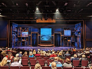
Everyman Theatre is a regional theatre with a professional repertory company of artists in downtown Baltimore, Maryland. Everyman's mission is to bring accessible and affordable theatre to the city of Baltimore. Everyman Theatre is located in downtown Baltimore in the Bromo Arts and Entertainment District.
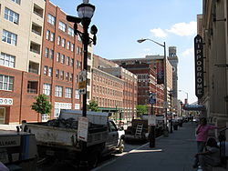
Downtown Baltimore is the central business district of the city of Baltimore traditionally bounded by Martin Luther King, Jr. Boulevard to the west, Franklin Street to the north, President Street to the east and the Inner Harbor area to the south.
Howard Street is a major north–south street through the central part of the city of Baltimore, Maryland. About 2+1⁄2 miles (4 km) long, the street begins at the north end of I-395 near Oriole Park at Camden Yards and ends near Johns Hopkins University, where it splits. To the right, it becomes Art Museum Drive, the one-block home of the Baltimore Museum of Art. To the left, it becomes San Martin Drive, which winds road along the western perimeter of the Johns Hopkins University campus and ends at University Parkway. Howard Street is named in honor of former Maryland governor John Eager Howard. Two other streets in Baltimore, John and Eager Streets, are also named after him.

Capitol View is a historic intown southwest Atlanta, Georgia neighborhood. The neighborhood is 2.5 miles from downtown and was named for its views of the Georgia State Capitol building. Its boundaries include Metropolitan Parkway to the east, Lee Street to the west, and the Beltline to the north. On the south, the border follows Arden Street, Deckner Avenue, and Perkerson Park.

Eutaw Street is a major street in Baltimore, Maryland, mostly within the downtown area. Outside of downtown, it is mostly known as Eutaw Place.

Mayfield is a quaint and historic community in northeast Baltimore, Maryland. It is bounded by Erdman Avenue on the south, Chesterfield Avenue on the north, Crossland Avenue on the east and Lake Montebello on the north and west. Homeowners belong to the Mayfield Improvement Association.
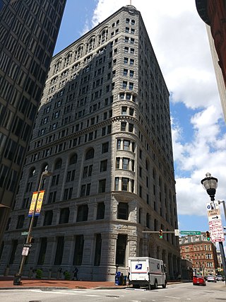
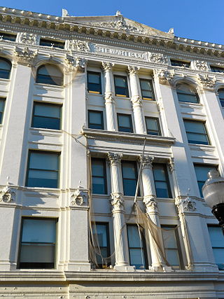
The Fidelity Building is a 15-story, 67 m (220 ft) high rise building in the central business district of Baltimore, Maryland. Completed in 1894, it was later the headquarters of the Fidelity and Deposit Company of Baltimore which was founded in 1892. As of 2024, the building is currently being converted into 220-unit mixed use apartments with ground level retail.

Charles Center is a large-scale urban redevelopment project in central Baltimore's downtown business district of the late 1950s and early 1960s. Beginning in 1954, a group called the "Committee for Downtown" promoted a master plan for arresting the commercial decline of central Baltimore. In 1955, the "Greater Baltimore Committee", headed by banker and developer James W. Rouse, joined the effort. A plan was developed by noted American urban planner and architect David A. Wallace, (1917−2004), strongly supported by Mayors Thomas L. J. D'Alesandro, Jr. (1947−1959) and Theodore R. McKeldin, and many in their administrations, which formed the basis of a $25 million bond issue voted on by the citizens of Baltimore City during the municipal elections in November 1958. The architects' view of the overall Charles Center Redevelopment Plan with the conceptions of possible buildings, lay-out and plan that was publicized to the voters that spring and summer before, only slightly resembles the actual buildings and designs that later were really constructed by the mid-1970s.

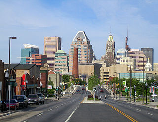
Baltimore is the most populous city in the U.S. state of Maryland. With a population of 585,708 at the 2020 census, it is the 30th-most populous city in the United States. Baltimore was designated an independent city by the Constitution of Maryland in 1851, and is currently the most populous independent city in the nation. As of the 2020 census, the population of the Baltimore metropolitan area was 2,838,327, the 20th-largest metropolitan area in the country. When combined with the larger Washington metropolitan area, the Washington–Baltimore combined statistical area (CSA) has a 2020 U.S. census population of 9,973,383, the third-largest in the country. Though the city is not located within or under the administrative jurisdiction of any county in the state, it is considered to be part of the Central Maryland region, together with the surrounding county that shares its name.

Harwood is a small neighborhood located in the central area of Baltimore, Maryland, USA. It sits east of Charles Village, south of Abell, west of Waverly and north of Barclay. Its boundaries are Guilford and Greenmount Avenues to the east and west, and 25th and 29th streets to the north and south. These streets together encompass about 14 city blocks.
UMBC Transit is the official bus system of the University of Maryland, Baltimore County. Along with the Maryland Transit Administration (MTA), the UMBC community has public transit access to nearby areas such as Catonsville, Arbutus, Maryland, and Baltimore City.
Bromo Arts District is one of four designated arts district in Baltimore, MD and is centered around the Emerson Bromo-Seltzer Tower, which houses artist studios. The district is roughly bounded by Park Avenue on the east, Lombard Street on the south, Paca Street on the west and Martin Luther King Jr. Boulevard and Read Street on the north and is adjacent to the neighborhoods of Mount Vernon and downtown Baltimore. It is home to the University of Maryland Medical Center, Lexington Market, Westminster Hall and Edgar Allan Poe's gravesite, the former Martick's Restaurant Francais and many cultural institutions including the Hippodrome Theatre, the Everyman Theatre, the Eubie Blake National Jazz and Cultural Center. It is also home to A.T. Jones and Sons, the oldest costume company in the United States.

The West Baltimore Innovation Village District is a neighborhood district of Baltimore City that will specialize in attracting startup companies and other employers to West Baltimore. Following the Death of Freddie Gray and the subsequent 2015 Baltimore protests, government leaders decided to launch the innovation district as a way to attract redevelopment and revitalization to the areas hardest hit by the protests. The district includes the neighborhoods of Mondawmin, Coppin Heights, Penn-North, Reservoir Hill and Bolton Hill.