History
Sandtown is located in a historically black area of West Baltimore neighboring the once affluent Upton. In the second half of the 20th century, Sandtown experienced economic depression, housing abandonment, crime, and the effects of the Baltimore riot of 1968. [2] [4] [5] Whereas in the 1950s and 1960s famous African American performers such as Billie Holiday and Diana Ross performed there and it was sometimes referred to as Baltimore's Harlem, by the time of the 2015 protests and rioting over the death of Freddie Gray, 3% of its population was incarcerated, a third of its housing abandoned, 20% of working age people were unemployed, and a third of residents were living in poverty. [6]
In 2015 Wall Street Journal op-ed columnist William Galston drew lessons from the history of Port Clinton, Ohio, to Baltimore and reported 52% unemployment among 16 to 64 year-olds in the Sandtown-Winchester neighborhood, twice the unemployment rate of Baltimore as a whole. [7] [8]

Towson is an unincorporated community and a census-designated place in Baltimore County, Maryland, United States. The population was 55,197 as of the 2010 census. It is the county seat of Baltimore County and the second-most populous unincorporated county seat in the United States.

Algiers is a historic neighborhood of New Orleans and is the only Orleans Parish community located on the West Bank of the Mississippi River. Algiers is known as the 15th Ward, one of the 17 Wards of New Orleans. It was once home to many jazz musicians and is also the second oldest neighborhood in the city.
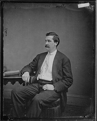
Harry Ward Gilmor served as the Baltimore City Police Commissioner, head of the Baltimore City Police Department in the 1870s, but he was most noted as a daring and dashing Confederate cavalry officer during the American Civil War. Gilmor's daring raids, such as The Magnolia Station Raid through north-central Maryland in July 1864 during the third major Confederate invasion of the North gained his partisans fame as "Gilmor's Raiders".

"Pigtown", also known as "Washington Village" is a neighborhood in the southwest area of Baltimore, bordered by Martin Luther King Jr. Boulevard to the east, Monroe Street to the west, Russell Street to the south, and West Pratt Street to the north. The neighborhood acquired its name during the second half of the 19th century, when the area was the site of butcher shops and meat packing plants to process pigs transported from the Midwest on the B&O Railroad; they were herded across Ostend and Cross Streets to be slaughtered and processed.

Mondawmin is a neighborhood located in the city of Baltimore, Maryland, United States. The neighborhood is surrounded by Druid Hill Park, the Whitelock Community, and Lower Park Heights. Included within its boundaries are Frederick Douglass High School, and Mondawmin Mall. The Baltimore Metro Subway serves the neighborhood, with a station at Mondawmin Mall that is also a hub for many bus routes.

Upton is a neighborhood in Baltimore City, Maryland, United States. The neighborhood is in the western section of the city, roughly between Fremont Avenue and McCulloh Street, extending from Dolphin Street to Bloom Street. Its principal thoroughfare is Pennsylvania Avenue.

Union Square is a neighborhood located in the Sowebo area of Baltimore. It dates to the 1830s and includes a historic district of houses and commerce buildings.

John Kirby, was an American jazz double-bassist and bandleader. In addition to sideman work, Kirby is remembered for leading a successful chamber jazz sextet in the late 1930s and early 1940s, which scored several hit songs including "Loch Lomond" and the debut recording of "Undecided", a jazz standard. He is perhaps the first musician in the chamber jazz genre. Earlier in his career he also played trombone and tuba.
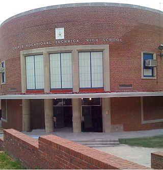
Carver Vocational-Technical High School – fully George Washington Carver Vocational-Technical High School – also known as Carver Vo-Tech, is a public vocational-technical high school located in the western part of Baltimore, Maryland, United States and part of the Baltimore City Public Schools system.

Barclay is a neighborhood in the center of Baltimore City. Its boundaries, as defined by the City Planning Office, are marked by North Avenue, Greenmount Avenue, Saint Paul and 25th Streets. The neighborhood lies north of Greenmount West, south of Charles Village, west of East Baltimore Midway, and east of Charles North and Old Goucher. The boundary between the Northern and Eastern police districts runs through the community, cutting it roughly in half.

Medfield is a neighborhood located in north Baltimore, Maryland, United States of America. It is located to the north of the trendy Hampden neighborhood and south of affluent Roland Park neighborhood. Its unofficial boundaries are Coldspring Lane to the north; Jones Falls Expressway to the west; Falls Road/Hickory Avenue to the east; and West 41st Street to the south.

Maryland State Department of Education (MSDE) is a division of the state government of Maryland in the United States. The agency oversees public school districts, which are 24 local school systems—one for each of Maryland's 23 counties plus one for Baltimore City. Maryland has more than 1,400 public schools in 24 public school systems, with a 2019 enrollment of approximately 900,000. Of the student body, 42% are on FARMS and 22% are Title 1.

Baltimore City Public Schools (BCPS), also referred to as Baltimore City Public School System (BCPSS) or City Schools, is a public school district in the city of Baltimore, state of Maryland, United States. It serves the youth of Baltimore City. Traditionally however, the Baltimore City Public Schools system has usually never referred to itself as a "district," as the operation of the schools was synonymous with the city of Baltimore. Its headquarters are located on 200 East North Avenue at North Calvert Street in the Dr. Alice G. Pinderhughes Administration Building.

Remington is a neighborhood in northern Baltimore bordered to the north by Hampden, Wyman Park, and Johns Hopkins University and to the east by Charles Village. The southernmost boundary is North Avenue and the long southwestern boundary is formed by Falls Road in the I-83 corridor. The neighborhood is split between two Baltimore City Council Districts.

Harwood is a small neighborhood located in the north-central area of Baltimore, Maryland, USA. It sits east of Charles Village, south of Abell, west of Waverly and north of Barclay. Its boundaries are Guilford and Greenmount Avenues to the east and west, and 25th and 29th streets to the north and south. These streets together encompass about 14 city blocks.
The American city of Baltimore, Maryland, is notorious for its crime rate, which ranks well above the national average. Violent crime spiked in 2015 after the death of Freddie Gray on April 19, 2015, which touched off riots and an increase in murders. The city recorded 348 homicides in 2019, a number second only to the number recorded in 1993 when the population was nearly 125,000 higher.
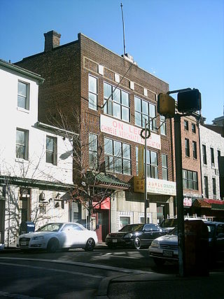
The U.S. city of Baltimore, Maryland is home to a small Chinatown. Historically, Baltimore had at least two districts that were called "Chinatown" where the first one existed on the 200 block of Marion Street during the 1880s. A second and current location is at the 300 block of Park Ave., which was dominated by laundries and restaurants. The initial Chinese population came because of the transcontinental railroad, however, the Chinese population never exceeded 400 as of 1941. During segregation, Chinese children were classified as "white" and went to the white schools. Chinatown was largely gone by the First World War due to urban renewal. Although Chinatown was largely spared from the riots of the 1960s, most of the Chinese residents moved to the suburbs. As of 2009, the area still shows signs of blight and does not have a Chinese arch. As of 2017, the area has become an “immigration hub” for Ethiopian people. In 2018, a mural of a Chinese dragon and an African lion was painted to signify the past as a Chinatown and the present as an African neighborhood. A night market in September 2018 marked the first Asian celebration of the area to an area that was “long forgotten and neglected”.
Youth Opportunity Academy is a public, alternative high school located in the Sandtown-Winchester neighborhood of Baltimore, Maryland. The school allows students who have dropped out to obtain either high school diplomas or GEDs. The school is located in the Lafayette Square Community Center, in a building that was originally built in 1972 and originally served as a branch of the Enoch Pratt Free Library.