
Locust Point is a peninsular neighborhood in Baltimore, Maryland. Located in South Baltimore, the neighborhood is entirely surrounded by the Locust Point Industrial Area; the traditional boundaries are Lawrence street to the west and the Patapsco River to the north, south, and east. It once served as a center of Baltimore's Polish-American, Irish-American and Italian-American communities; in more recent years Locust Point has seen gradual gentrification with the rehabilitation of Tide Point and Silo Point. The neighborhood is also noted as being the home of Fort McHenry.

Federal Hill is a neighborhood in Baltimore, Maryland, United States that lies just to the south of the city's central business district. Many of the structures are included in the Federal Hill Historic District, listed on the National Register of Historic Places in 1970. Other structures are included in the Federal Hill South Historic District, listed in 2003.
Interstate 395 (I-395) is an Interstate Highway in the U.S. state of Maryland. Known as Cal Ripken Way, the highway runs 1.33 miles (2.14 km) from I-95 north to Howard Street and Camden Street in Baltimore. I-395 is a spur that heads north from I-95 over the Middle Branch of the Patapsco River toward Downtown Baltimore, where it provides access to the Inner Harbor and the Baltimore Convention Center. The Interstate also serves the Camden Yards Sports Complex, which contains M&T Bank Stadium and Oriole Park at Camden Yards, homes of the Baltimore Ravens and Baltimore Orioles, respectively. I-395 also serves as the southern terminus of Martin Luther King Jr. Boulevard, an urban arterial that provides a western bypass of downtown Baltimore and connects I-95 with U.S. Route 40, US 1, and I-83. The Interstate is maintained by the Maryland Transportation Authority (MDTA) and, like all Interstates, is a part of the National Highway System.

Canton is a historic waterfront neighborhood in Baltimore, Maryland, United States. The neighborhood is along Baltimore's outer harbor in the southeastern section of the city, roughly two miles east of Baltimore's downtown district and next to or near the neighborhoods of Patterson Park, Fell's Point, Highlandtown, and Brewers Hill.
Sowebo is a community-chosen name for a historic area in the South West of Baltimore City.

"Pigtown", also known as "Washington Village", is a neighborhood in the southern area of Baltimore, bordered by Martin Luther King Jr. Boulevard to the east, Monroe Street to the west, Russell Street to the south, and West Pratt Street to the north. The neighborhood acquired its name during the second half of the 19th century, when the area was the site of butcher shops and meat packing plants to process pigs transported from the Midwest on the B&O Railroad; they were herded across Ostend and Cross Streets to be slaughtered and processed.

Union Square is a neighborhood located in the Sowebo area of Baltimore. It dates to the 1830s and includes a historic district of houses and commerce buildings.

Westport is a neighborhood in south Baltimore, Maryland. Westport is a majority African-American neighborhood that has struggled with crime, housing abandonment, and unemployment in the past decade. The neighborhood is bordered by the Middle Branch of the Patapsco River on the east, the city neighborhoods of Cherry Hill, Brooklyn and the southwestern Baltimore County community of Lansdowne to the southwest, Hollins Ferry Road and the Mount Winans and Lakeland neighborhoods to the west, and Interstate 95 to the north, along with the South Baltimore communities of Federal Hill and Otterbein. The Baltimore–Washington Parkway runs through the middle of Westport and intersects with Interstate 95, the main East Coast super-highway, north to south, Maine to Florida.
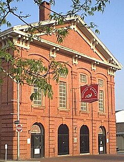
Hollins Market is the name of the oldest existing public market building in the city of Baltimore, Maryland. It is a contributing property to the Union Square-Hollins Market Historic District.
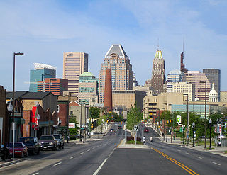
Downtown Baltimore is the central business district of Baltimore traditionally bounded by Martin Luther King, Jr. Boulevard to the west, Franklin Street to the north, President Street to the east and the Inner Harbor area to the south.

Downtown Omaha is the central business, government and social core of the Omaha-Council Bluffs metropolitan area, U.S. state of Nebraska. The boundaries are Omaha's 20th Street on the west to the Missouri River on the east and the centerline of Leavenworth Street on the south to the centerline of Chicago Street on the north, also including the CHI Health Center Omaha. Downtown sits on the Missouri River, with commanding views from the tallest skyscrapers.

Medfield is a neighborhood located in north Baltimore, Maryland, United States of America. It is located to the north of the trendy Hampden neighborhood and south of affluent Roland Park neighborhood. Its unofficial boundaries are Coldspring Lane to the north; Jones Falls Expressway to the west; Falls Road/Hickory Avenue to the east; and West 41st Street to the south.

Mount Clare, also known as Mount Clare Mansion and generally known today as the Mount Clare Museum House, is the oldest Colonial-era structure in the City of Baltimore, Maryland, U.S.A. The Georgian style of architecture plantation house exhibits a somewhat altered five-part plan. It was built on a Carroll family plantation beginning in 1763 by barrister Charles Carroll the Barrister, (1723–1783), a descendant of the last Gaelic Lords of Éile in Ireland and a distant relative of the much better-known Charles Carroll of Carrollton, (1737–1832), longest living signer of the Declaration of Independence and the richest man in America in his later years, also the layer of the First Stone of the new Baltimore and Ohio Railroad, just a short distance away in 1828.

Lion Brothers Company Building is a historic factory located at 875 Hollins St, Baltimore, Maryland 21201. It is a multi-level building that once housed the operations of the Lion Brothers embroidery company. The original building was constructed in 1885 and expanded several times over the subsequent 75 years. In 1958 the Lion Brothers moved their production facility to another location allowing Marcus & Farber and Globe Screen Printing to move in. The building has been vacant since 2002 and Cross Street Partners has plans to restore the building as a local innovation center.

"Mount Winans" is a mixed-use residential, commercial and industrial neighborhood in the southwestern area of the City of Baltimore in Maryland. Its north, south and east boundaries are marked by the various lines of track of the CSX Railroad. In addition, Hollins Ferry Road running to the south towards suburban Baltimore County in the southwest and further connecting with adjacent Anne Arundel County to the southeast, draws its western boundary.
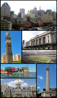
Baltimore is the most populous city in the U.S. state of Maryland, as well as the 30th most populous city in the United States, with a population of 602,495 in 2018 and also the largest such independent city in the country. Baltimore was established by the Constitution of Maryland as an independent city in 1851. As of 2017, the population of the Baltimore metropolitan area was estimated to be just under 2.802 million, making it the 21st largest metropolitan area in the country. Baltimore is located about 40 miles (64 km) northeast of Washington, D.C., making it a principal city in the Washington-Baltimore combined statistical area (CSA), the fourth-largest CSA in the nation, with a calculated 2018 population of 9,797,063.

Hollins–Roundhouse Historic District is a national historic district in Baltimore, Maryland, United States. It is a primarily residential area characterized by 19th century rowhouses. The neighborhood is historically significant due to its association with the development of rail transportation in Maryland. Additional historical significance comes from the neighborhood's association with ethnic immigration to Baltimore. During the 1840s and 1850s the area was a center of settlement for Baltimore's German and Irish communities, many of whom immigrated to the United States to work in the rail industry. Later, from the 1880s to the 1920s, the neighborhood became established as the center of Baltimore's Lithuanian immigrant community. Because of the large Lithuanian population in the area north of Hollins Street, the area became known as Little Lithuania. A few remnants of the neighborhood's Lithuanian heritage still remain, such as Lithuanian Hall located on Hollins Street.

Bromo Arts District is one of three designated arts district in Baltimore, MD and is centered around the Emerson Bromo-Seltzer Tower, which houses artist studios. The district is roughly bounded by Park Avenue on the east, Lombard Street on the south, Paca Street on the west and Martin Luther King Jr. Boulevard and Read Street on the north and is adjacent to the neighborhoods of Mount Vernon and downtown Baltimore. It is home to the University of Maryland Medical Center, Lexington Market, Westminster Hall and Edgar Allan Poe's gravesite, the former Martick's Restaurant Francais and many cultural institutions including the Hippodrome Theatre, the Everyman Theatre, and the Eubie Blake National Jazz and Cultural Center. It is also home to A.T. Jones and Sons, the oldest costume company in the United States.

Carroll Park is a nearly 117-acre (47 ha) public park located in the historic Washington Village-Pigtown neighborhood in southwestern Baltimore, Maryland. The park is bordered by Washington Boulevard to the south, Monroe Street to the west, Bayard Street to the east, and the Mount Clare Branch of the Baltimore Terminal Subdivision railroad to the north. The park also extends westward beyond the Montgomery Ward Warehouse and Retail Store to include the Carroll Park Golf Course.

