
Catonsville is a census-designated place (CDP) in Baltimore County, Maryland. The population was 44,701 at the 2020 US Census. The community is a streetcar suburb of Baltimore along the city's western border. The town is known for its proximity to the Patapsco River and Patapsco Valley State Park, making it a regional mountain biking hub. The town is also notable as a local hotbed of music, earning it the official nickname of "Music City, Maryland." Catonsville contains the majority of the University of Maryland, Baltimore County (UMBC), a major public research university with close to 14,000 students.

Charles Village is a neighborhood located in the north-central area of Baltimore, Maryland, USA. It is a diverse, eclectic, international, largely middle-class area with many single-family homes that is in proximity to many of Baltimore's cultural amenities. Nearby are the Baltimore Museum of Art, the Homewood campus of The Johns Hopkins University, Olmstead's Wyman Park, the weekly Waverly Farmers Market, and the arts district, Station North. Homes are Baltimore brick and stone row houses, many dating from the 1890s. Running from downtown north is the historic boulevard, Charles Street, where Baltimore's Easter Promenade once took place.

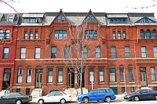
Bolton Hill is a neighborhood in Baltimore, Maryland, with 20 blocks of mostly preserved buildings from the late 19th century. It is listed on the National Register of Historic Places, preserved as a Baltimore City Historic District, and included within the boundaries of Baltimore National Heritage Area. The neighborhood is bounded by North Avenue, Mount Royal Avenue, Cathedral Street, Dolphin Street, and Eutaw Place. Bolton Hill is a largely residential neighborhood with three-story row houses with red brick, white marble steps, and high ceilings. There are also larger more ornate originally single-family houses, many houses of worship, parks, monuments, and a few large apartment buildings. Many significant residents have lived in the neighborhood, including F. Scott Fitzgerald, Woodrow Wilson, the Cone sisters, and Florence Rena Sabin.
The Station North Arts and Entertainment District is an area and official arts and entertainment district in the U.S. city of Baltimore, Maryland. The neighborhood is marked by a combination of artistically-leaning commercial ventures, such as theaters and museums, as well as formerly abandoned warehouses that have since been converted into loft-style living. It is roughly triangular, bounded on the north by 20th Street, on the east by Greenmount Avenue, and on the south and west by the tracks of Amtrak's Northeast Corridor, though the neighborhood's boundaries include a one-block wide extension over the tracks.

Mount Washington is an area of northwest Baltimore, Maryland. It is a designated city historic district and divided into two sections: South Road/Sulgrave to the southeast and Dixon's Hill to the north. The Mount Washington Historic District was listed on the National Register of Historic Places in 1990 with a boundary increase in 2001, with five contributing buildings and four contributing structures.
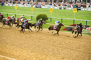
Pimlico is a neighborhood in Baltimore, Maryland. It is the site of Pimlico Race Course, which holds the Preakness Stakes, one of the three legs of the Triple Crown of Thoroughbred Racing. From 1896 through 1915, Pimlico was also the home of Baltimore's Electric Park, a popular amusement park located near the intersection of Reisterstown Road and Belvedere Avenue.

Reservoir Hill is a historic neighborhood in the city of Baltimore, Maryland, United States. It is located south of Druid Hill Park, north of Bolton Hill, east of Penn-North, and west of Jones Falls. It is bounded by Druid Park Lake Drive, the Jones Falls Expressway, North Avenue, and McCulloh Street. It is contained in the 21217 ZIP code.

Butchers Hill is a neighborhood in Southeast Baltimore, Maryland, United States. It is north of Fells Point, east of Washington Hill, and northwest of Patterson Park. It is south of Fayette Street, west of Patterson Park Avenue, north of Pratt Street, and east of Washington Street. It is in the 21231 zip code.

Park Heights is an area of Baltimore City, Maryland, that lies approximately 5 miles northwest of downtown Baltimore and within two miles of the Baltimore County line. A 1,500-acre community, Park Heights comprises 12 smaller neighborhoods that together contain approximately 30,000 residents. It is bounded on the south by Druid Park Drive, on the west by Wabash Avenue, on the east by Greenspring Avenue, and on the north by Northern Parkway. Interstate-83 is less than a half mile to the east. Two major roadways—Park Heights Avenue and Reisterstown Road—run north-south through Park Heights, serving as the neighborhood's "Main Streets" as well as commuter corridors. Limited commercial uses—primarily retail—are scattered along these roads; there is also some industrial activity on the neighborhood's western edge.

Greenmount West is a neighborhood in the state-designated Station North Arts District of Baltimore. Its borders consist of Hargrove Alley to the west, Hoffman Street and the Amtrak railroad tracks to the south, the south side of North Avenue to the north, and Greenmount Avenue to the east. Residents in the area include a mix of low, middle and high income families, artists, commuters to Washington DC and working-class Baltimoreans with the majority of residents of African American descent.
Forest Park is a region of Northwest Baltimore, Maryland located west of Reisterstown Road, south of Northern Parkway, and east of the Baltimore City/County line. In Baltimore, the region is referred to by locals simply as "Forest Park" and includes the neighborhoods of Ashburton, Callaway-Garrison, Central Forest Park, Dolfield, Dorchester, East Arlington, Forest Park, Grove Park, Hanlon Longwood, Howard Park, Garwyn Oaks, Purnell, West Arlington, West Forest Park, and Windsor Hills.
Ashburton is a middle class, predominantly African-American neighborhood in the Forest Park region of northwestern Baltimore City, Maryland. It is located near Liberty Heights Avenue and Hilton Street, and is characterized by mixture of single family housing and blocks of row houses.
Sidney William Bijou was an American developmental psychologist who developed an approach of treating childhood disorders using behavioral therapy, in which positive actions were rewarded and negative behaviors were largely ignored, rather than punished.
Edgecomb, also known as Parklane, is a neighborhood in the North District of Baltimore, located between the neighborhoods of Cylburn (north) and Greenspring (south). Its boundaries are marked by Dupont Avenue (north), Coldspring Lane (south), Pimlico Road (west) and Greenspring Avenue (east). Central Park Heights, is located on the opposite side of Pimlico Road in the Northwest District. The neighborhood of Coldspring is located to Edgecomb's east, across Greenspring Avenue.

Cylburn is a neighborhood in the North District of Baltimore, located between the neighborhoods of Levindale (north) and Edgecomb (south). Its boundaries are marked by Cylburn Avenue (north), Dupont Avenue (south), Pimlico Road (west) and Greenspring Avenue (east). Central Park Heights, is located on the opposite side of Pimlico Road in the Northwest area of Baltimore City. Cylburn Arboretum and the neighborhood of Cold Spring are located to Cylburn's east, across Greenspring Avenue. The heavily wooded property with its historic mansion and grounds, walking trails, famous collections and gardens overlook the Jones Falls Valley with the Jones Falls Expressway further to the east.
Garwyn Oaks is a neighborhood in the Northwest District of Baltimore, located between the neighborhoods of Windsor Hills and Hanlon Longwood. The boundaries of its somewhat rectangular shape are marked by Woodhaven Avenue (north), Gwynns Falls Parkway (south), Garrison Boulevard (east) and Chelsea Terrace (west).
Langston Hughes is a neighborhood in the Northwest District of Baltimore, located between the neighborhoods of Central Park Heights (east) and Woodmere. Its roughly pentagonal boundaries are marked by West Belvedere Avenue (northwest), Litchfield Avenue (northeast), Reisterstown Road (south) and Oakmont Avenue (east).
The history of Russians in Baltimore dates back to the mid-19th century. The Russian community is a growing population and constitutes a major source of new immigrants to the city. Historically the Russian community was centered in East Baltimore, but most Russians now live in Northwest Baltimore's Arlington neighborhood and in Baltimore's suburb of Pikesville.

The history of Hispanics and Latinos in Baltimore dates back to the mid-20th century. The Hispanic and Latino community of Baltimore is the fastest growing ethnic group in the city. There is a significant Hispanic/Latino presence in many Southeast Baltimore neighborhoods, particularly Highlandtown, Upper Fell's Point, and Greektown. Overall Baltimore has a small but growing Hispanic population, primarily in the Southeast portion of the area from Fells Point to Dundalk.
Levindale is a neighborhood in northwest Baltimore which includes Sinai Hospital, the Levindale Hebrew Geriatric Center and Hospital, and a small number of detached homes and apartment buildings towards its south.


